Maps of Landkreis Breisgau-Hochschwarzwald
Geographica Provinciarum Sveviae Descriptio =
Mollova mapová sbírka Hurter, Johann Christoph Bodenehr, Gabriel
Geographica Provinciarum Sveviae Descriptio =
Mollova mapová sbírka Hurter, Johann Christoph Bodenehr, Johann Georg
Le Theatre de la Guerre Sur le Haut Rhein
1 : 142000 Mollova mapová sbírka Sanson, Guillaume
185. Freiburg i. Brg., uit: Topographische Uebersichtskarte des Deutschen Reiches / herausgegeben v. d. Kartogr. Abt. d. Königl. Preuß. Landesaufnahme
1 : 200000 titelvariant: Topogr. Übersichtskarte des Deutschen Reiches; Annotatie: Titel boven bladen ook: Topogr. Übersichtskarte des Deutschen Reiches; Annotatie geografische gegevens: Op elk blad twee maatstokken: 10 Kilometer = 5,5 cm; 1 geogr. Meile = 3,6 cm; Legenda onder op elk blad Königlich Preußische Landesaufnahme. Kartographische Abtheilung [S.l : Königlich Preußische Landesaufnahme, Kartographische Abtheilung]
Nova descriptio ditionis Tigurinae regionumque finitimarum
1 : 95000 1 Karte auf 6 Bl. Joh. Conradus Gygerus, P. delineavit ; Joh. Georgius Gygerus, F. in aes incidi ; curavit per Johannem Meyerum Ao. 1685
Le Flambeau de la Guerre Allumee au Rhin
Mollova mapová sbírka Delisle, Guillaume Schenk, Peter II
Wandkarte von Basel und Umgebung
1 : 50000 1 Karte in 4 Teilen bearbeitet von J. Randegger Carl Detloff, Basel
Hans Konrad Gyger's Züricher-Cantons-Carte 1667
1 : 32000 1 Karte in 56 Teilen Hans Konrad Gyger
Schaffhauser Gebiet samt den Grentzen und umligenden Orten
1 : 50000 1 Karte auf 4 Bl. von Heinrich Peyer verfertigt 1685 [Verlag nicht ermittelbar], [Erscheinungsort nicht ermittelbar]
Hans Konrad Gyger's Züricher-Cantons-Carte 1667
1 : 32000 1 Karte in 56 Teilen Hans Konrad Gyger
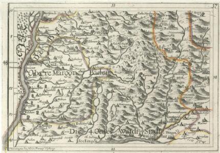
Delineatio Der vom Rothen Haus uber den Schwarzwald bis Feldburg 14 Stund lang alt und um gezogener Linien , Verhackh, und aufgeworffenen Schanzen, und Redouten
Mollova mapová sbírka
Kanton Zürich: Staats-, Gemeinde- und Genossenschaftswaldungen: Blatt 1: a) Titelblatt; b) Hüntwangen, Wil; Situationsplan
1 : 25000 a) Mit Erklärung der für die Kennzeichnung von Staats-, Gemeinde- und Genossenschaftswaldungen verwendeten Farben. b) Ausgangskarten: Blätter 15 (Neunkirch) und 24 (Hüntwangen) des Topographischen Atlasses der Schweiz (Siegfried-Karte). Ohne Erstellungsdatumsangabe. Hartmann, Karl, Forstadjunkt im Zürcher Oberforstamt, von Aarau, in Unterstrass
[Geologische Karte der Umgebungen von Waldshut]
1 : 50000 Schill, Julius Chr. Fr. Müller'sche Hofbuchhandlung
Nova descriptio ditionis Tigurinae regionumque finitimarum
1 : 95000 1 Karte auf 6 Bl. Joh. Conradus Gygerus, P. delineavit ; Joh. Georgius Gygerus, F. in aes incidi ; curavit per Johannem Meyerum Ao. 1685
Mappa, in quâ Tractus Regionis Inter Doneschingā et Veros Danubii Fontes interjacentis Geographicè repraesentatur Ut hoc etiam modo facilè cuivis appareat, quàm minus rectè in Doneschingâ arce fontes Danubii quaerantur; quam naturali è contrà iure illa scaturigo aquae est prope Brukelrein in altissimo totius sylvae Herzyniae monte pro Veris Danubii fontibus habenda sit
1 : 200000 Mollova mapová sbírka Marsili, Luigi Ferdinando
Hans Konrad Gyger's Züricher-Cantons-Carte 1667
1 : 32000 1 Karte in 56 Teilen Hans Konrad Gyger
Hans Konrad Gyger's Züricher-Cantons-Carte 1667
1 : 32000 1 Karte in 56 Teilen Hans Konrad Gyger
Hans Konrad Gyger's Züricher-Cantons-Carte
1 : 32000 Blatt 42 Gyger, Hans Conrad ; Zeller-Werdmüller, Heinrich Hofer & Burger
Meßtischblatt [8216] : Stühlingen, 1882
1 : 250000 Stühlingen. - 1:25000. - Leipzig: Giesecke & Devrient, 1882. - 1 Kt.
Meßtischblatt [8215] : Grafenhausen, 1922
1 : 250000 Grafenhausen. - Revid. 1878 und 1895, Steindruckausgabe 1922. - 1:25000. - Karlsruhe: Kunstdr. Künstlerbund, 1922. - 1 Kt.
Meßtischblatt [8213] : Schönau (Zell i. W.), 1927
1 : 250000 Schönau (Zell i. W.). - Hrsg. 1895, bericht. 1927. - 1:25000. - Karlsruhe: Kunstdr. Künstlerbund, 1927. - 1 Kt.
Meßtischblatt [8214] : St. Blasien, 1926
1 : 250000 St. Blasien. - Hrsg. 1920, Steindruckausgabe 1926. - 1:25000. - Karlsruhe: Kunstdr. Künstlerbund, 1926. - 1 Kt.
Meßtischblatt [8212] : Wies (Blauen), 1928
1 : 250000 Wies (Blauen). - Hrsg. 1915, bericht. 1928. - 1:25000. - Karlsruhe: Kunstdr. Künstlerbund, 1928. - 1 Kt.
Meßtischblatt [8116] : Bonndorf, 1878
1 : 250000 Bonndorf. - 1:25000. - Leipzig: Giesecke & Devrient, 1878. - 1 Kt.
Meßtischblatt [8115] : Lenzkirch, 1926
1 : 250000 Lenzkirch. - Hrsg. 1895, revid. 1926, Steindruckausg. 1926. - 1:25000. - Karlsruhe: Kunstdr. Künstlerbund, 1926. - 1 Kt.
Meßtischblatt [8113] : Todtnau, 1885
1 : 250000 Todtnau. - [Ausg.] 1876 u. 1885. - 1:25000. - Leipzig: Giesecke & Devrient, 1885. - 1 Kt.
Meßtischblatt [8114] : Feldberg (Altglashütten), 1926
1 : 250000 Feldberg (Altglashütten). - Steindruckausg. - 1:25000. - Karlsruhe: Kunstdr. Künstlerbund, 1926. - 1 Kt.
Meßtischblatt [8112] : Staufen (Belchen), 1928
1 : 250000 Staufen (Belchen). - 1:25000. - Karlsruhe: Kunstdr. Künstlerbund, 1928. - 1 Kt.
Meßtischblatt [8016] : Donaueschingen, 1921
1 : 250000 Donaueschingen. - Steindruckausg., rev. 1920. - 1:25000. - Leipzig: Giesecke & Devrient, 1921. - 1 Kt.