Maps of Schleswig-Holstein
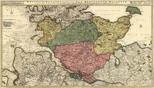
Holsatiae Ducatus, Vernaculè Das Hertzogtum Holstein
1 : 310000 Mollova mapová sbírka Visscher, Nicolaes Schenk, Peter II
Holsatiae Tabula Generalis
1 : 310000 Mollova mapová sbírka Wit, Frederik de Mortier, Pierre
Ducatus Holsatiae Descriptio Novissima
1 : 490000 Mollova mapová sbírka Visscher, Nicolaes Visscher, Nicolaus
Ducatus Holsatiae Descriptio Novissima
1 : 490000 Mollova mapová sbírka Visscher, Nicolaes Jansz. Visscher, Nicolaus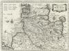
Dvcatvs Holsatiae Nova Tabvla
1 : 850000 Mollova mapová sbírka Merian, Matthaeus Merian, Matthäus - dědici
Ducatus Holsatiae Nova Tabula [Karte] Alluvies propè Detzbul [...] [Nebenkarte] Tabula Barmerensis [...] [Nebenkarte] , in: Novus atlas absolutissimus, Bd. 1, S. 143.
1 Karte aus Atlas Janssonius Offizin
NOVA & ACCVRATISSIMA | DVCATVS | HOLSATIÆ | TABVLA
Auctore Joh. Meyer Husumensi. Matthias Und Clauß Petersen Goldtschmide gebr. Hus. sculps. [Amsterdam : Joan Blaeu]
Ducatus Holsatiae Nova Tabula [Karte] [Umgebung von Dagebul] [und] Tabula Barmorensis Meggerensis [...] [2 Nebenkarten], in: Theatrum orbis terrarum, sive, Atlas novus, Bd. 1, S. 177.
1 Karte aus Atlas Blaeu, Joan Blaeu, Willem Janszoon
Ducatus Holsatiae Nova Tabula [Karte] Alluvies propè Detzbul [...] [Nebenkarte] Tabula Barmerensis [...] [Nebenkarte], in: Le théâtre du monde, ou, Nouvel atlas contenant les chartes et descriptions de tous les païs de la terre, Bd. 1, S. 143.
1 Karte aus Atlas Blaeu, Willem Janszoon und Blaeu, Joan Blaeu, Willem Janszoon
Ducatus Holsatiae Nova Tabula [Karte] Alluvies propè Detzbul [...] [Nebenkarte] Tabula Barmerensis [...] [Nebenkarte], in: Novus Atlas, das ist, Weltbeschreibung, Bd. 1, S. 114.
1 Karte aus Atlas Blaeu, Joan Blaeu, Willem Janszoon
Ducatus Holsatiae Nova Tabula [Karte] Alluvies propè Detzbul [...] [Nebenkarte] Tabula Barmerensis [...] [Nebenkarte] , in: Gerardi Mercatoris et I. Hondii Newer Atlas, oder, Grosses Weltbuch, Bd. 1, S. 109.
1 Karte aus Atlas Mercator, Gerhard und Hondius, Jodocus Jansson, Jan
Ducatus Holsatiæ descriptio novissima / excudebant Janssonio-Waesbergii et Moses Pitt
1 : 365000 Annotatie: Origineel is Blad 82 in atlas factice; Annotatie geografische gegevens: Schaalstok: Die Maße der Teutsche Meilln, 3=5,9 cm; Rechtsboven: XLI Johannes Janssonius van Waesberge -1681?; Moses Pitt ca. 1654-1696 [Amstelodami : apud Ioannem Ianssonium]
Holsatia ducatus [Karte], in: Gerardi Mercatoris Atlas, sive, Cosmographicae meditationes de fabrica mundi et fabricati figura, S. 146.
1 Karte aus Atlas Mercator, Gerhard Montanus, Petrus
Holsatia ducatus [Karte], in: Atlas, sive, Cosmographicae meditationes de fabrica mundi et fabricati figura, S. 141.
1 Karte aus Atlas Mercator, Gerhard
Geographische Vorstellung der jämerlichen Wasser-Flutt in Nieder-Teutschland
1 : 590000 Mollova mapová sbírka Homann, Johann Baptist Homann, Johann Baptista
Holsatiae Descriptio. [Karte], in: Theatrum orbis terrarum, S. 120.
1 Karte aus Atlas Ortelius, Abraham
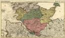
General-Karte von den Herzogthümern Schleswig, Holstein und Lauenburg, den Füstenthümern Lübeck und Ratzeburg, und den freien und Hansestädten Hamburg und Lübek
1 : 450000 Dánsko Geerz, F. F. Geerz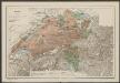
Nieuwe Caerte waerinne vertoont wordt de gantsche Vaert van Amsterdam over de Watten tot de stadt Hamborch toe. [Karte, Teil 2], in: Gerardi Mercatoris et I. Hondii Newer Atlas, oder, Grosses Weltbuch, Bd. 1, S. 152.
1 Karte aus Atlas Mercator, Gerhard und Hondius, Jodocus Jansson, Jan
Die Gebiethe der vier freien Staedte Hamburg, Lübeck, Bremen und Frankfurt, nebst dem Freistaate Krakau
in vier Special Charten dargestellt von F. W. Streit L. Beyer sc. Nürnberg : Friedrich Campe
Nieuwe Caerte waerinne vertoont wordt de gantsche Vaert van Amsterdam over de Watten tot de stadt Hamborch toe. [Karte, Teil 2], in: Novus atlas absolutissimus, Bd. 2, S. 95.
1 Karte aus Atlas Janssonius Offizin
Ducatus Holsatiae summâ diligentiâ accuratâq. censura noviter editus
1 : 569000 Holštýnsko Visscher, Claes Jansz. a Nicolao Iohanide Piscatore
Ducatus Holsatiae, summa diligentia accurataq. censura noviter editus
1 : 569000 Bad Segeberg (Německo) Visscher, Claes Jansz. a Nicolao Iohanide Piscatore
Schleswig, Holstein, Lauenburg.
1 : 445000 Weiland, C. F. (Carl Ferdinand), d. 1847
General Karte der Herzogthümer Schleswig Holstein und Lauenburg
1 : 500000 Lübeck (Německo : oblast) Stolzenberg, Alfred Pauliny, J. J. J.J. Pauliny
Geologische-Uebersichtskarte der Provinz Schleswig-Holstein
1 : 300000 Meyn, Ludwig Verlag der Simon Schropp'schen Hof-Landkartenhandlung (J.H. Neumann)
General Karte der Herzogthümer Sleswig Holstein und Lauenburg der Fürstenthümer Lübek und Ratzeburg
Dvcatvs Holsatiae
Holštýnsko Bouttats, Gaspar
Holsatia ducatus
1 Karte : Kupferdruck ; 33 x 46 cm Mercator; Hondius Henricus Hondius