Maps of Arques
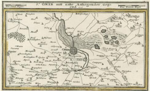
St. Omer mitt nahe Anliegender Gegend
1 : 150000 Mollova mapová sbírka Bodenehr, Gabriel Bodenehr, Gabriel
Carte du gouuerneme[nt] de St. Omer
1 Karte : Kupferdruck ; 11 x 15 cm s.n.
FANVM | S. AVDOMARI | Vulgo | S. OMER
[Amsterdam : Joan Blaeu]
CASLETVM vulgo Cassel | Olim CASTELLVM MORINORVM : [bird's-eye view]
[Amsterdam : Joan Blaeu]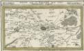
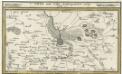
Arien und St. Venand Mitt nahe Anliegender Gegend
1 : 150000 Mollova mapová sbírka Bodenehr, Gabriel Bodenehr, Gabriel
Carte du gouuernement de Terouane
1 Karte : Kupferdruck ; 11 x 15 cm s.n.
Perfecte afbeeldinge van de Stercke Stat | AYRE ofte ARIEN | Aldus Belegert en verovert door Louys de dertiende, Coning | van Vrancryck ende Navarra in den Iare 1641. | PLAN D'AYRE | avec sez Forts, Ligncs [sic!] de Circonvalations & | Attaques de la Ville, aßiégée par Loys le 13. | Roy de France et Navarre | l'Ann 1641.
[Amsterdam : Joan Blaeu]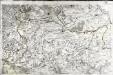
[Saint-Omer]
1 Blatt : 60 x 91 cm s.n.
Boloniensis comitatvs
1 Karte : Kupferdruck ; 15 x 20 cm Lambert Andreae
Flandriae pars occidentalis
1 : 185000 Belgie Hondius, Henricus sumptibus Henrici Hondii
Bolonia & Guines Comitatus [Karte], in: Gerardi Mercatoris Atlas, sive, Cosmographicae meditationes de fabrica mundi et fabricati figura, S. 238.
1 Karte aus Atlas Mercator, Gerhard Montanus, Petrus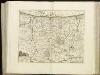
[108][111] Pars Flandriae occiden[talis] ..., uit: Atlas sive Descriptio terrarum orbis
Annotatie: Gedigitaliseerde versie. Amsterdam. Heiloo : Picturae (vervaardiger), 2015. tiff-bestand. Gedigitaliseerd: 07-01-2015; Origineel: Universiteitsbibliotheek Vrije Universiteit (XL.05127.-) ; Netherlands; Titelpagina ontbreekt Wit, Frederik de Amsterdam : Frederick de Wit
Bolonia & Guines Comitatus [Karte], in: Gerardi Mercatoris et I. Hondii Newer Atlas, oder, Grosses Weltbuch, Bd. 2, S. 23.
1 Karte aus Atlas Mercator, Gerhard und Hondius, Jodocus Jansson, Jan
Flandriae Pars Occidentalis [...] [Karte], in: Novus atlas absolutissimus, Bd. 3, S. 115.
1 Karte aus Atlas Janssonius Offizin
Tabula Comitatvs Artesiae
1 : 200000 Mollova mapová sbírka Wit, Frederik de Wit, Frederick
Carte Particuliere des environs de Dunkerque, Bergues, Furnes, Gravelines, Calais, et Autres
1 : 116600 Mollova mapová sbírka Fricx, Eugène Henry Covens, Johannes I
Calais 81, uit: [W. Liebenow's Special-Karte von Mittel-Europa]
1 : 300000 titelvariant: W. Liebenow's Mittel-Europa; Annotatie: Titel boven de bladen: W. Liebenow's Mittel-Europa Johannes Wilhelm Liebenow 1822-1897 Hannover : Hermann Oppermann
PARS | FLANDRIÆ | TEVTONICÆ | OCCIDENTALIOR.
Amsterdami Exc. | Guiljelmus et Iohannes Blaeu.

Pars Flandriae Teutonicae Occidentalior. [Karte], in: Theatrum orbis terrarum, sive, Atlas novus, Bd. 1, S. 375.
1 Karte aus Atlas Blaeu, Joan Blaeu, Willem Janszoon
Pars Flandriae Teutonicae Occidentalior. [Karte], in: Le théâtre du monde, ou, Nouvel atlas contenant les chartes et descriptions de tous les païs de la terre, Bd. 1, S. 388.
1 Karte aus Atlas Blaeu, Willem Janszoon und Blaeu, Joan Blaeu, Willem Janszoon
Pars Flandriae Teutonicae Occidentalior. [Karte], in: Novus Atlas, das ist, Weltbeschreibung, Bd. 1, S. 362.
1 Karte aus Atlas Blaeu, Joan Blaeu, Willem Janszoon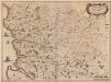
Descriptio Boloniae Pontieu Comit. S. Pauli Cum adiacentibus [Karte], in: Novus atlas absolutissimus, Bd. 4, S. 56.
1 Karte aus Atlas Janssonius Offizin
Calais 81, uit: Special-Karte von Mittel-Europa / nach amtlichen Quellen bearbeitet von W. Liebenow
1 : 300000 titelvariant: W. Liebenow's Mittel-Europa; Annotatie: Titel boven de bladen: W. Liebenow's Mittel-Europa Johannes Wilhelm Liebenow 1822-1897 Frankfurt a. M. : Ludwig Ravenstein
Atrebates
1 Karte : Kupferdruck ; 41 x 54 cm Sanson; Robert de Vaugondy chés le Sr. Robert geogr. du roi quai de l'Horloge du palais

Map of water supply: Hazebrouck
1 : 100000 Series of maps on water supplies. 2nd Army area water supply. Secret. Hazebrouck War Office
5 Saint-Omer.
1 : 86400 Cassini family; Cassini, Cesar-Francois, 1714-1784