Maps of Poland
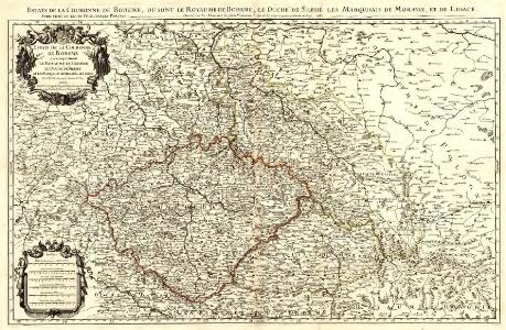
Estats de la Couronne de Boheme
1 : 900000 Mollova mapová sbírka Sanson, Guillaume Jaillot, Alexis Hubert
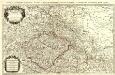
Boheme, Silesie, Moravie et Lusace.
1 : 900000 Robert de Vaugondy, Gilles, 1688-1766
Carte du Royaume de Pologne
1 : 900000 Bělorusko Nordmann, A. P. H. Gilly Artaria
Sbírka map a diagramů použitých na mírových konferencích v Paříži v letech 1919 - 1920
Československá republika
Mapa historického vývoje Československého státu (od XIV. do XIX. století)
Přehledná letecká mapa Republiky československé: Carte aéronautique d'ensemble de la République Tchécoslovaque
Vojenský zeměpisný ústav
87-88. Poland. The World Atlas.
1 : 1500000 USSR (Union of Soviet Socialist Republics).
Charte vom Königreiche Galizien
1 : 2000000 Halič (Polsko a Ukrajina) Kipferling, Karl Joseph Kunst und Industrie Comptoirs
Charte vom Königreiche Galizien
Halič (Polsko a Ukrajina) Kipferling, Karl Joseph Walch, Johann in J. Riedl's Kunsthandlung
Partie, l'Allemagne. Europe 14.
1 : 1641836 Vandermaelen, Philippe, 1795-1869
Postkarte vom östlichen und westlichen Galizien
Halič (Polsko a Ukrajina) Ponheimer, Kilian im von Reilly'schen Landkarten und Kunstwerke Verschleiss Komptoir
Přehled listů mapy generální 1:200 000, speciální 1:75 000 a původního vyměřování (topogr. sekcí) 1:25 000

Polonia Regnum, et Silesia Ducatus. [Karte], in: Novus Atlas, das ist, Weltbeschreibung, Bd. 1, S. 73.
1 Karte aus Atlas Blaeu, Joan Blaeu, Willem Janszoon
Polonia Regnum, et Silesia Ducatus. [Karte], in: Le théâtre du monde, ou, Nouvel atlas contenant les chartes et descriptions de tous les païs de la terre, Bd. 1, S. 94.
1 Karte aus Atlas Blaeu, Willem Janszoon und Blaeu, Joan Blaeu, Willem Janszoon
Polonia Regnum, et Silesia Ducatus. [Karte], in: Theatrum orbis terrarum, sive, Atlas novus, Bd. 1, S. 102.
1 Karte aus Atlas Blaeu, Joan Blaeu, Willem Janszoon
Bez titulu: Československo

Mapa vývoje České koruny od XIV. století
1 : 3900000 Česko Hocke, Jan Kapras, Jan
Novissima Poloniae Regni Descriptio. [Karte], in: Novus atlas absolutissimus, Bd. 1, S. 90.
1 Karte aus Atlas Janssonius Offizin
Reliefkarte von Galizien und Süd-Polen

Československo v mapách

Karte der Eisenbahnen Deutschlands
1 : 700000 Südost-Blatt Stich, Druck u. Verlag des lithographischen Instituts von Aug. Wehrt
Poland - South. Pergamon World Atlas.
1 : 1250000 Polish Army Topography Service
Estats de la couronne de Boheme qui comprennent le royaume de Boheme le duché de Silesie et les marquisats de Moravie et de Lusace
1 : 900000 Lužice (Německo) Sanson, Nicolas Jaillot, Alexis-Hubert H. Iaillot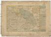
Reise-Charte durch das Königreich Böhmen Hertzogthum Schlesien Marggrafthum Maehren und Lausitz
1 : 296000 Lužice (Německo) Schreiber, Johann Georg J.G. Schreibern
Neue und zuverlaesige General Karte von Böhmen Mähren Schlesien und Lausitz
1 : 998000 Lužice (Německo) Schütz, Carl Müller, Franz Artaria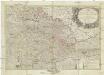
Neue und zuverlaesige General Karte von Koenigreich Boehmen, Maehren, Schlesien, und Lausitz
1 : 998000 Lužice (Německo) Schütz, Carl Frister, Joseph Joseph Frister
Polonia Et Silesia [Karte], in: Gerardi Mercatoris Atlas, sive, Cosmographicae meditationes de fabrica mundi et fabricati figura, S. 409.
1 Karte aus Atlas Mercator, Gerhard Montanus, Petrus