Maps of Regierungsbezirk Freiburg

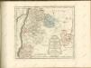
Imp. Caes. Carolo VI. Avgvsto Pio Victori gentis svae sideri felicissimo chorographiam hanc exhibentem primar. Regionvm Habspvrgicar sitvm positvmq brevibvs exterarvm ditionvm intervallis vt permistvm nec non vltimos Imperii Germ. Terminos perpetva transitvvm obsidionvm Hibernorvm Coactionvm vexatione agitatos antiqvae fidei et invictae testes pietatis svpplex dicat Provincia Brisgoia Avst. Ant. MDCCXVIII. Cum Privilegio Sac. Caes. Majestatis
1 : 241000 Mollova mapová sbírka Homann, Johann Baptist Homann, Johann Baptista
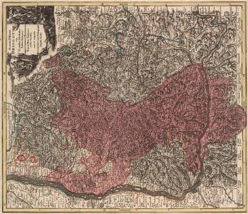
Accurata Delineatio Brisgoviae cum Civitatibus Silvestribus Austriae Anterioris, tanquam Limitum et Terminorum Imperii Rom. Germanici versus Occasum cura et impensis
1 : 242000 Mollova mapová sbírka Seutter, Matthäus Seutter, Matthäus
Die Landgrafschaft Nellenburg die Landvogtey Altorf
1 Karte : Kupferdruck ; 19 x 27 cm Reilly F. J. J. von Reilly
Nigra Sylva XI. Nova Tabula. [Karte], in: Claud. Ptolemaeus. Geographia lat. cum mappis [...], S. 374.
1 Karte aus Atlas Münster, Sebastian [und Ptolemaeus, Claudius]
Circulus siue Liga Sveviae Vulgo Schwabische Kraiß
1 : 950000 Mollova mapová sbírka Seltzlin, David Plantin, Christoph
Die in und um Schwaben gelegenen Östreichischen Antheile in der ämtlichen Sprache Vorderöstreich : Nro. 150
Reilly, Franz Johann Joseph von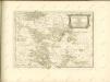
Totius Rheni â fontibus usque ad Ostia Novissima Descriptio
1 : 550000 Mollova mapová sbírka Steudner, Johann P. Bodenehr, Johann Georg Steüdner, Johann Philipp
Würtenberg
Mollova mapová sbírka Hoffmann, Johannes Hoffmann, Johann

Generalkarte von Zentraleuropa

[Exactissima Helvetiae, Rhaetiae, Valesiae ... tabula]
1 : 850000 9 Karten [Kopie von Adrian Braakman] [chez Pierre Schenk et Adrian Braakman], [Amsterdam]
Carte routière No. 28 Les bords du Rhin (Strasbourg, Bâle, Constance), uit: Les bords du Rhin : Strasbourg, Bâle, Constance / P. Bineteau, del.
1 : 350000 Bineteau, P. Paris : Taride
Stuttgart

Karte vom Schwarzwald
1 : 400000 Schnars, Carl Wilhelm ; Sachs, Friedrich Carl Winters's Universitätsbuchhandlung
Totius s.r.i. circuli Suevici tabula chorographica, 3
1 Blatt : R. et J. Ottens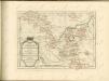

Generalkarte von Württemberg: Blatt III
1 : 1500000 Terrainzeichnung: Bach, Topograf und Hauptmann Lithografie: Rebmann und Sommer Herausgeber: K. statistisch-topografisches Büro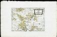
Die Landgrafschaft Nellenburg die Landvogtey Altorf die Grafschaft Hohenberg und die kleinern durch das östreichische Schwaben zerstreuten Besitzungen mit der Stadt Kostanz und den vier Donaustaedten : Nro. 153
Reilly, Franz Johann Joseph von
Suevia universa IX. tabulis delineata, 5
1 Blatt : s.n.
Cursus Rheni a Basilea usque ad Bonnam, III. sect. exhibit
1 : 258000 Alsasko (Francie) Delisle, Guillaume per Homann. Heredes
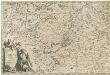
Die Lande des Fürsten von Fürstenberg
1 Karte : Kupferdruck ; 23 x 26 cm Reilly F. J. J. von Reilly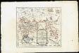
Die Lande des Fürsten von Fürstenberg oder die Landgrafschaften Stühlingen und Baar die Grafschaft Heiligenberg und die Herrschaften Gundelfingen Möskirch Jungnau und Trochtelfingen Mit der Schwarzenbergischen Landgrafschaft Klettgau ...
Reilly, Franz Johann Joseph von
Curcus Rheni Supra Argentoratum et Regiones Adiacenter
1 : 240000 Mollova mapová sbírka Seutter, Matthäus Seutter, Matthäus
Pars Sueviæ australior
1 Karte : Kupferdruck ; 46 x 61 cm L'Isle; Lotter apud Tobiam Conradum Lotter calcogr
Per Inclyti Circuli Suevici Supremorum Ordinum :
1 : 160000 Mollova mapová sbírka Pfeffel, Johann Andreas Pfeffel, Johann Andreas I.
Per Inclyti Circuli Suevici Supremorum Ordinum :
1 : 160000 Mollova mapová sbírka Pfeffel, Johann Andreas Pfeffel, Johann Andreas I.
Partie septentrionale de la Souabe
1 : 280000 par Guillaume De L'Isle A Amsterdam : chez J. Covens et C. Mortier
Le Theatre de Bellone :
Mollova mapová sbírka Schenk, Pieter Braakman, Adriaan