Maps of Bezirk Horn
Müllerova mapa Čech XXIV
1 : 132000
Umgebungen von Frainersdorf und Zlabings
1 : 144000 K.K. Militärisches Geographisches Institut
Monumenta Cartographica Bohemiae II.: Müllerova mapa
Umgebungen von Göffritz

Drosendorf (Mahren).
from Spezialkarte der osterreichisch-ungarischen Monarchie.
II. vojenské mapování 16
1 : 144000
Special-Karte zu den Corps-Manövern bei Waidhofen a[n] [der Thaya] 1981
1 : 75000 Waidhofen an der Thaya (Rakousko) K.u.k militär-geographisches Institut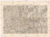
Special-Karte zu den Corps-Manövern bei Waidhofen a[n] [der Thaya] 1891
1 : 75000 Waidhofen an der Thaya (Rakousko) K.u.k militär-geographisches Institut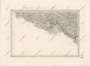
Special - Karte der Markgrafschaft Maehren und des Herzogthums Schlesien
Special-Karte zu den Corps-Manövern bei Waidhofen a[n] [der Thaya] 1891
1 : 75000 Waidhofen an der Thaya (Rakousko)
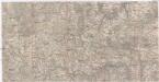
Horn (Nieder-Osterreich).
from Spezialkarte der osterreichisch-ungarischen Monarchie.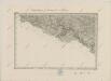
II. vojenské mapování 16
1 : 144000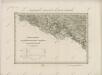
II. vojenské mapování 16
1 : 144000
Podrobná mapa Markrabství moravského a Vévodství slezského
1 : 100000 Jemnice (Třebíč, Česko : oblast) Srp, Jan Jos. R. Vilímek
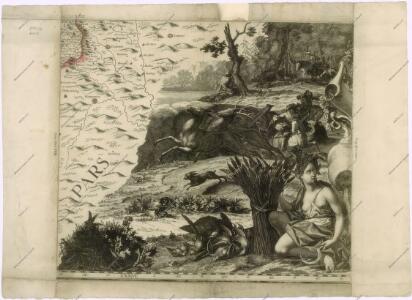
Mappa geographica regni Bohemiae in duodecim circuloc divisae ... Sectio. XXIV.

Podyjí
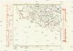
Komunikační mapa země Moravskoslezské
1 : 100000 Dačice (Česko : oblast) Morslez. zem. výbor
Slavonice
1 : 75000 Slavonice-oblast (Česko) Vojenský zeměpisný ústav
Slavonice a Drosendorf
1 : 75000 Rakousko Vojenský zeměpisný ústav
Umgebungen von Krems
Kremže (Rakousko : oblast)
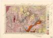
Geognostische Karte der Umgebungen von Krems und von Manhardsberge
1 : 71200 Kremže (Rakousko) Čížek, Johann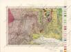
Umgebungen von Krems

III. vojenské mapování 4455
1 : 75000
Drosendorf
1 : 75000 Dyje (Česko a Rakousko : řeka : oblast) Zimburg K. u. k. Militärgeographisches Institut

[Mapový list]
1 : 25000 Morava (Česko) Vojenský zeměpisný ústav
[Mapový list]
1 : 25000 Morava (Česko) Vojenský zeměpisný ústav
III. vojenské mapování 4455/2-4
1 : 25000