Maps of Austria
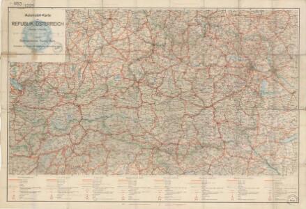
Automobil-Karte der Republik Österreich: Österreichischen Touring-Buch

Der Oesterreichische Kreis
1 : 1340000 Rakousko (1526-1804) Güssefeld, Franz L. Liesganig, Joseph bey Homannischen Erben
Der Oesterreichische Kreis
1 : 1340000 Rakousko Güssefeld, Franz L. Liesganig, Joseph bey den Homannischen Erben
Sbírka map a diagramů použitých na mírových konferencích v Paříži v letech 1919 - 1920

Autriche
1 : 1000000 Rakousko Čs. voj. zeměp. ústav
Karte der Republik Österreich
1 : 1500000 Rakousko Rothaug, Johann Georg Kartogr. Anstalt G. Freytag & Berndt
Karte der Republik Österreich
1 : 1500000 Rakousko Kartograph. Institut
Austria.
1 : 1220000 Cary, John, ca. 1754-1835
Südwestliche deutsche Bundesstaaten
1 : 2500000 Německo jižní Huber, D.
Karte der Republik Österreich
1 : 1500000 Wien : Kartographisches, früher Militärgeographisches Institut
Der Oesterreichische Kreis
1 : 1380000 Evropa střední Güssefeld, Franz L. Liesganig, Joseph bey den Homannischen Erben
The South East Part of Germany
1 : 3500000 Mollova mapová sbírka Moll, Herman Moll, Hermann
Maiestas Austriaca sive circ. archiducat. Austriae
1 : 3400000 Evropa střední Seutter, Matthäus Lotter, Tobias Conrad Tobias Conrad Lotter
Republik Österreich
1 : 2000000 Rakousko R. Lechner (Wilh. Müller)
Maximi totius Europae Fluminis Danubii Cursus per Germaniam Hungariamque
1 : 1200000 Mollova mapová sbírka Janssonius, Johannes Janssonius, Johannes I
Deutsch-Oesterreichische Länder
1 : 5000000 Österreich

Oestereichischer Kreis
Allgemeiner Atlas [Walch, Johannes] im Verlag bei Johannes Walch
Mapa Rakouska
1 : 2000000
[Rakousko]
1 : 2115000 Evropa střední
Nieuwe kaart van de Beyersche en Oostenryksche Kreits
1 : 2000000 Annotatie: Uit: Nieuwe Hand-Atlas. - Amsterdam : Tirion, 1744 Te Amsterdam : by Isaak Tirion
Austria.
1 : 2700000 Bowen, Frances
Charte von Oestreich Steyermark, Illyrien und Tyrol
1 : 1600000 Ilýrie
Charte von Oestreich Steyermark Illyrien und Tyrol
1 : 1550000 Ilýrie
Leopoldi Magni filio Iosepho I. Avgvsto Romanorvm et Hvng. regi ad capessendum Rhenanae militiae imperium in castra proficiscenti hanc Germaniae Avstriacae generalem tabvlam
1 : 1430000 Evropa střední Homann, Johann Baptist Io. Bapt. Homann
Übersichtskarte der evangelischen Kirche Augsb. und Helv. Confession
1 : 864000 Chorvatsko Strehl, Anton k. k. evangel. Oberkirchenrathe

Süd-Östliches Deutschland, enthält die Oesterreichischen Lande
Schul-Atlas über alle Theile der Erde nach dem neuesten Zustande, und über das Weltgebäude Stieler, Adolf bei Justus Perthes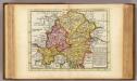
The south east part of Germany.
1 : 3500000 Moll, Herman, d. 1732