Maps of Slovakia

Podrobný přehled politického rozdělení Slovenska
Vojenský zeměpisný ústav
Podrobný přehled politického rozdělení Slovenska
Slowakei
1 : 500000 Slovensko Justus Perthes
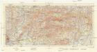
Podrobný přehled politického rozdělení Slovenska a Podkarp. Rusi
Vojenský zeměpisný ústav
Podrobný přehled politického rozdělení země Slovenské a Podkarpatoruské
Vojenský zeměpisný ústav
Nieder-Ungern
Slovensko západní Kipferling, Karl Joseph Berken von Ottendorff, Johann im Verlage des Kunst- und Industrie Comptoirs
Nieder-Ungern
Slovensko západní Kipferling, Karl Joseph Berken von Ottendorff, Johann im Verlage des Kunst- und Industrie Comptoirs
Flusskarte für die Projectirung der Ent- und Bewässerung der March und Thaya Gebiete
1 : 500000 Dolní Rakousko (Rakousko) Mannsfeld, Grafen Hieronymus, zu Edwards, Edward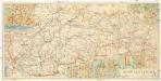
Země slovenská
1 : 500000 Banská Štiavnica (Slovensko) Fastr Eduard
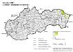
Slowakei 2001. Ukrainer (ukrajinská národnost’)
Slowakei ethnische Gruppe, Ukrainer Hofinger, Veronika
Slowakei 2001. Magyaren (mad’arská národnost’)
Slowakei ethnische Gruppe, Magyaren Hofinger, Veronika
Mapa správního rozdělení ČSR

Slowakei 2001. Nationalitäten
Slowakei ethnische Gruppe Hofinger, Veronika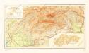
Příruční mapa Slovenska
Uibersichts Karte der Eisen-Bahn-Route, zwischen Wien und Bochnia, nebst den Flügel-Bahnen
1 : 1150000 Bochnia (Polsko) H. Engel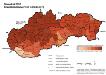
Slowakei 2001. Slowaken (slovenská národnost’)
Slowakei ethnische Gruppe, Slowaken Hofinger, Veronika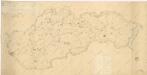
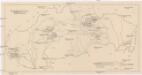
Přehledná mapa resortních staveb na Slovensku

Der ostdeutsche Kolonialtyp
Slowakei Städtebau
Slovensko
1 : 750000 Slovensko
Braun: Autová mapa I-III (Slovensko, Podkarpatská Rus)
Der deutschen Siedlungen in der Slowakei
1 : 577000 Slovensko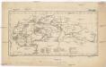
[Oblasti průmyslu a nerostné těžby na Slovensku]
Slovensko Salač, Klement Walch, Johann
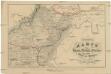
Partie du Royaume de Hongrie, vers le Septentrion, et l'Occident
1 : 680000 Mollova mapová sbírka Coronelli, Vincenzo Maria Nolin, Jean Baptiste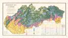
Geonomická mapa Slovenska

Nástěnná mapa hejtmanství Čáslavského

Conjuctio Danubij cum Oder vel per Moravam et Beczwam vel per Vagum, et Olsam
Mollova mapová sbírka Vogemont, Lothar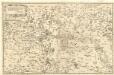
Deß Konigreichs Ungern Fürnembster theil, Geographische beschreibung
1 : 650000 Mollova mapová sbírka Hulsius, Levinus Hulsius, Levinus
Markgrafschaft Mähren und Herzogthum Ober u. Nieder-Schlesien
1 : 1850000 Morava (Česko) Stieler, Adolf Mädel, Adolf Justus Perthes


