Maps of Metropolitan France

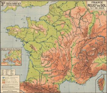
France relief du sol
Vidal de La Blache, Paul
France Chemins de Fer Principales lignes de navigation
Vidal de La Blache, Paul
France Villes
Vidal de La Blache, Paul
France Chemins de Fer Principales lignes de navigation
Vidal de La Blache, Paul
France relief du sol
Vidal de La Blache, Paul
France cours d'eau
Vidal de La Blache, Paul

Regni Galliae seu Franciae et Navarrae...

Carte de la France
1 : 3200000 Francie Poirson Jean M.d d'Estampes
France Villes
Vidal de La Blache, Paul
France Agriculture
Vidal de La Blache, Paul
Carte physique et routiere de la France, de la Suisse.
1 : 2000000 Brue, Adrien Hubert, 1786-1832
France Provinces en 1789
Vidal de La Blache, Paul
France divisions militaires
Vidal de La Blache, Paul
France cours d'eau
Vidal de La Blache, Paul
France Physique.
1 : 2500000 Vivien St Martin, L.
France, departments.
1 : 4500000 Tanner, Henry S.
France Industrie et commerce
Vidal de La Blache, Paul

Nouvelle carte des postes de France
1 Karte : Kupferdruck ; 50 x 63 cm Jaillot; Jaillot chez le Sr. Jaillot geographe du roy joignant les g.ds Augustins aux deux globes
Carte physyque de la France
1 Karte : Kupferdruck ; 30 x 35 cm, Bildgrösse 34 x 53 cm Pasquier; Chalmandrier; Verrier; Denis chez l'auteur, chez Mr. Pasquier ruë St. Jacques vis-a-vis le college de Louis le grand, chez Verrier géographe du roi ruë des 4 fils aux marais
France, in Departments.
1 : 4500000 Finley, Anthony
Carte des chemins de fer
1 : 1000000 Alžírsko Cartes Taride
Carte de France et des pays limitrophes au 500.000e
1 : 500000 Francie Service Géographique de l'Armée
[Francie]
1 : 2100000 Francie Müller, Franz
Les routes exactes des postes du Royaume de France
1 : 2600000 Aug. Vindel. : Matth. Seutter excud.
Carte physique et hydrographique de la France
1 Karte : Kupferdruck ; 49 x 54 cm Dupain-Triel chés l'auteur rue des Noyers près St. Yves
Gallia postarvm geographice designata
1 Karte : Kupferdruck ; 48 x 55 cm Jaillot Homännische Erben
France in Departments.
1 : 2232000 Johnston, Alexander Keith