Maps of Spain

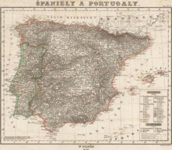
Španiely a Portugaly.


Spanien Und Portugal.
1 : 3700000 Vogel, C.
Spanien und Portugal

Spain and Portugal.
1 : 3380000 Sharpe, J.

Spanien und Portugal
Volksschul-Atlas über alle Teile der Erde Lange, Henry Druck und Verlag von Georg Westermann
Indice gráfico de los ferrocarriles de España
1 mapa. Datat a partir de 1900 aproximadament. 0 0
The kingdoms of Spain & Portugal / compiled & reduced from numerous topographic surveys, the maritime survey of Don Vicente Tofino &c. ; London, publishd 1st Janury 1826 by Richard H. Laurie
1 Mapa, col. Ed. anglesa basada en obra de Tofiño Laurie, Richard H. Richard H. Laurie
Spanien und Portugal
1 : 2260000 entworfen und gezeichnet von C. F. Weiland Weimar : Verlag des Geographischen Instituts
Typus Hispaniae [Karte], in: Gerardi Mercatoris et I. Hondii Newer Atlas, oder, Grosses Weltbuch, Bd. 2, S. 168.
1 Karte aus Atlas Mercator, Gerhard und Hondius, Jodocus Jansson, Jan
Espagne, Portugal.
1 : 3600000 Janvier, Jean
Spanien und Portugal
Handatlas über alle Theile der Erde und über das Weltgebäude Stieler, Adolf Justus Perthes
Novissima et accuratissima tabula regnorum Hispaniæ et Portugalliæ
1 Karte : Kupferdruck ; 46 x 59 cm Allard ex officina I. Cóvens et C. Mortier
Spanien und Portugal
Hand-Atlas über alle Theile der Erde nach dem neuesten Zustande und über das Weltgebäude Stieler, Adolf bei Justus Perthes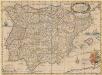
Typus Hispaniae ab Hesselo Gerardo delineata [...] [Karte], in: Novus atlas absolutissimus, Bd. 6, S. 15.
1 Karte aus Atlas Janssonius Offizin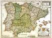
L'Espagne
1 Karte : Kupferdruck ; 38 x 51 cm Duval chez sa veuve sur le quay de l'orloge pres le palais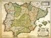
L'Espagne
1 Karte : Kupferdruck ; 38 x 51 cm Duval chez l'auteur proche du palais
Spanien und Portugal
1 : 2300000 entworfen und gezeichnet von C. F. Weiland L.G. Jaeger sc. Weimar : Verlag des Geograph. Instituts
Hispania
1 : 2610000 Portugalsko Delisle, Guillaume Mendes Silva, Rodrigo sumptibus Matth. Seutteri
Spanien und Portugal
Portugalsko
Le royaume d'Espagne
1 Karte : Kupferdruck ; 50 x 64 cm Crépy chez Crepy rue St. Jacques à St. Jacques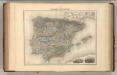
Espagne et Portugal.
1 : 3375000 Migeon, J.
Mapa general de España
1 Karte : Kupferdruck ; 48 x 58 cm López Tomás López
Spanien und Portugal
1 : 2300000 entworfen und gezeichnet von C. F. Weiland L.G. Jaeger sc. Weimar : Verlag des Geograph. Instituts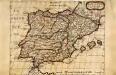
Espagne
1 Karte : Kupferdruck ; 19 x 24 cm Sanson; Winter s.n.
Soubor němých map pro gymnasia a odborné školy

Spanien und Portugal
Schul-Atlas über alle Theile der Erde nach dem neuesten Zustande, und über das Weltgebäude Stieler, Adolf bei Justus Perthes
Spanien und Portugal
1 : 2350000 Cádiz (Španělsko) Weiland, Karl Ferdinand im Verlage des Geographischen Instituts