Maps of Hradčany

Praha, hlavní město ČSR : Fastrův obrázkový plán a průvodce
1 : 10000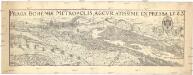
Praga Bohemiae metropolis, accvratissime expressa 1562
Praha (Česko) Keix Unie
Grundriss der kais. Königl. Hauptstadt Prag im Königreich Böhmen

Neuester Grundriss von Prag
1 : 12000 Schuldes, W. J.G. Calvesche Buchhandlung
Grundriss der könig. Hauptstadt Prag im Königreich Böhmen
Praha (Česko) Berha, J. Schönfeldischen Officin
[Grundriss der könig. Hauptstadt Prag im Königreich Böhmen]
Praha (Česko) Platzer, Thad. Berha, J. Schönfeldischen Officin
Plan der königlichen Hauptstadt Prag

Grundrisz der Kőnigl. Haupstadt Prag

Grundriss der königlichen Hauptstadt Prag : Herausgegeben auf Veranlassung und Kosten des böhmischen Nationalmuseums
1 : 4320
Praha : plán kulturních památek
1 : 10000
Grundriss der koniglichen Hauptstadt Prag

Neuester Grundrisz von Prag
1 : 10500 Praha (Česko) Kronberger und Weber
Plán Prahy z roku 1816

PLAN DE PRAG
1 : 8000 Praha (Česko) Bailleul, Nicolas chez Bailleul le jeune
Praha : názorné plány a rejstřík

Prag - c6068-1-002 - Kaiserpflichtexemplar der Landkarten des stabilen Katasters
1 : 2880
Prag - c6068-1-006 - Kaiserpflichtexemplar der Landkarten des stabilen Katasters
1 : 2880
Prag - c6068-1-003 - Kaiserpflichtexemplar der Landkarten des stabilen Katasters
1 : 2880
Prag - c6068-1-001 - Kaiserpflichtexemplar der Landkarten des stabilen Katasters
1 : 2880
Prag - c6068-1-004 - Kaiserpflichtexemplar der Landkarten des stabilen Katasters
1 : 2880
Prag - c6068-1-005 - Kaiserpflichtexemplar der Landkarten des stabilen Katasters
1 : 2880
Niveau-Karte der Stadt Prag
1 : 20000
Grundriss der königlichen Hauptstadt Prag
Praha (Česko) Jüttner, Josef Drda, Josef Jan Alois Nationalmuseum
Grundriss der königlichen Hauptstadt Prag
Praha (Česko) Jüttner, Josef Drda, Josef Jan Alois Nationalmuseum
Grundriss von Prag, nach den besten Hülfsmitteln dargestellt
1 : 125000 gestochen von W. Schuldes Prag : J. G. Calve'sche Buchhandlung
Plan von Prag

Praha. Mapy staré Prahy k letům 1200, 1348 a 1419

Grund-Rieß uber den Kossirz- und Czibulker Hoff auch Czisarzska
1 : 2500 Košíře (Praha, Česko) Mann, Johann Joseph Florian
Polohopisný plán Prahy
Praha (Česko) K. Hübner


