Maps of Banten

West-Java / Reproductiebedrijf Top. dienst (Reproduced by Topographical Service)
Officieële Vereeniging voor Toeristenverkeer in Nederlandsch-Indië Batavia Batavia : Travellers Official Information Bureau
Caart eeniger ryken gelegen op het eyland Groot-Java bestaande in het koningrijk Jaccatra, de Regentschappen Tjandjoer, Bandong, Timbanganten en Batoe Lejan als mede een gedeelte van Parrakkanmoentjang en Crawang
[S.l. : s.n.]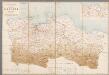
Overzichtskaart van de Residentie Batavia / [Topographische Inrichting]
1 : 250000 Annotatie: Met een overzicht van de bestuurlijke indeling; Kaartrand afgesneden Topographische Inrichting, Nederlands-Indië [Batavia : Topographische Inrichting]
Batavia

Overzichtskaart van de residentie Batavia / [door het] Topographisch Bureau
Topographisch Bureau Batavia Batavia : Topographisch Bureau
Overzichtskaart van de Residentie Batavia / Topographische Inrichting
Topografische Inrichting Batavia Batavia : Topographische Inrichting
Batavia / prepared under the direction of the Chief of Engineers U.S. Army by the Army Map Service
Army Map Service Washington D.C. Washington D.C. : Army Map Service
Kaart van de Residentie Batavia

Overzichtskaart van den ontworpen spoorweg van Batavia naar Anjer : met zijtakken van Doerie naar Tangerang en van Tanahabang naar Weltevreden
Bataviaasch Nieuwsblad Batavia ; Weltevreden : G. Kolff & Co.
Bandoeng / prepared under the direction of the Chief of Engineers, U.S. Army by the Army Map Service
Army Map Service Washington D.C. Washington D.C. : Army Map Service
Bandoeng / prepared under the direction of the Chief of Engineers, U.S. Army by the Army Map Service
Army Map Service Washington D.C. Washington D.C. : Army Map Service
[Sukabumi]
1 : 200000 Joh. C. Stemler Cz.
[Jakarta]
1 : 200000 Joh. C. Stemler Cz.
[Cimahi]
1 : 200000 Joh. C. Stemler Cz.
[Purwakarta]
1 : 200000 Joh. C. Stemler Cz.
Tjitaroemwerken : overzichtskaart / opgemaakt [door] Soekrawinata, Poerwakarta den 300 1930
Poerwakarta : [s.n.]
Overzichtskaart betreffende den ontworpen spoorweg van Padalarang naar Krawang
[S.l. : s.n.]
Buitenzorg-Soekaboemi-Tjiandjoer / Topografische Inrichting, Batavia
Topografische Inrichting Batavia Batavia : Officieële Vereeniging voor Toeristen Verkeer
Buitenzorg-Soekaboemi-Tjiandjoer / Topografische Inrichting = Topographical Service
Topografische Inrichting Batavia Batavia : Topografische Inrichting = Topographical Service
Soekaboemi / prepared under the direction of the Chief of Engineers, U.S. Army by the Army Map Service
Army Map Service Washington D.C. Washington D.C. : Army Map Service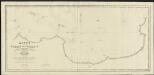
Kaart van de Reede van Batavia met de verschillende vaarwaters
1 : 50000 naar dezelve trigonometrisch opgenomen op last van den Schout Bijnacht E. Lucas door de Luitenants ter Zee B.G. Escher. L.A.C. Eschauzier, B.H. Staring, E.H. Boom en andere officieren van Z.M. Zeemagt uitg. door Jacob Swart ; gegraveerd door J.C. Zurcher ; getekend door G. A. Günther Amsterdam : Wed. G. Hulst van Keulen
Bajah / bewerkt door W.C.B. Koolhoven
[Batavia : Topografische Dienst]
Bandoeng / bewerkt door R.W. van Bemmelen
[Batavia : Topografische Dienst]
Poerwakarta / bewerkt door O. Ludwig
[Batavia : Topografische Dienst]
Java, Bie Winkoups (1867)
Bie Winkoups, d'après, le Lieutt. Hampt ... 1837. Paris
Hoogvlakte van Bandoeng : autowegenkaart / uitgave HOVIC
[Bandoeng] : HOVIC
Kaart van de Baai van Batavia en aangrenzende kuststrook
[Breda : Koninklijke Militaire Academie]
Garnizoenskaart Batavia en Omstreken / Topografische Dienst
Topografische Dienst Batavia Batavia : Reproductiebedrijf Topografische Dienst
Batavia en Omstreken / Topographische Inrichting
Topographische Inrichting Batavia : Topographische Inrichting


