Maps of Jambi

[Doesoenpeloempat] / opgenomen door den Topografischen Dienst in 1924-1928 en 1932-1934
Topografische Dienst Batavia Batavia : Reproductiebedrijf Topografische Dienst
Sketch of a journey from Moco-Moco to Pengkatan Jambee : including a visit to the large lake in Korinchi / by J. Barnes, 1818
Aardrijkskundig Genootschap Amsterdam Amsterdam : C.F. Stemler
Overzichtskaart van de Afdeeling Koerintji der Residentie Djambi / Topographische Inrichting
Topographische Inrichting Batavia Batavia : Topographische Inrichting
Moearalaboeh / published by War Office = uitgegeven door War Office ; revised and photolithographed by War Office
War Office Washington D.C. [Washington D.C.] : War Office
[Bangko]
Topografische Dienst Batavia Batavia : Reproductiebedrijf Topografische Dienst
Sawahloento / Survey of India
Survey of India [S.l.] : Survey of India
Schetskaart van de Residentie Djambi / Topographische Inrichting
Topographische Inrichting Batavia Batavia : Topographische Inrichting
Res[identie] Djambi
[S.l. : s.n.]
Overzichtskaart van het wegenstelsel in de Residentie Djambi

Schetskaart Residentie Djambi / gewerkt door den Opn[emer] B[innenlandsch] B[estuur] Daris

Kaart van een gedeelte van Midden-Sumatra / J. Postma, lith[ograaf]
Aardrijkskundig Genootschap Amsterdam Amsterdam : C.L. Brinkman
Bladwijzer van Midden Sumatra : 1:50.000
[S.l. : s.n.]
Schetskaart van Midden Sumatra : behoorende bij een verslag eener reis van Padang naar Djambi en Palembang / door J. Schouw Santvoort
Aardrijkskundig Genootschap Amsterdam Amsterdam : C.L. Brinkman
Het Minangkabausche land (Alam Minangkabau)
[S.l. : s.n.]
Kaart van Midden Sumatra / door D.D. Veth
Aardrijkskundig Genootschap Amsterdam [Leiden : E.J. Brill]
Routekaart Pakanbaroe - Batavia
[S.l. : s.n.
Bladwijzer van Midden Sumatra : 1:40.000
[S.l. : s.n.]
Bladwijzer van Oost-Sumatra : 1:100.000
[S.l. : s.n.]
Kaart van Midden-Sumatra : Gouver.nt v. Sumatra's Westkust, Zuid ged. d. R. Sumatra's-Oostkust, Afd. Lingga v.d. Res. Riouw en Onderh. en het Rijk Djambi/ [J.W. Stemfoort en J.J. ten Siethoff ; gereproduceerd op last van het Departement van Koloniën, aan de Topographische Inrichting te 's-Gravenhage, onder leiding van den Directeur C.A. Eckstein]
Ministerie van Koloniën Den Haag s-Gravenhage : Departement van Koloniën
7. Midden-Sumatra, uit: Atlas van Nederlandsch Oost-Indië / samengest. door Topographisch Bureau te Batavia van 1897-1904
Annotatie: Omgewerkte versie van: Atlas der Nederlandsche bezittingen in Oost-Indië / naar de nieuste bronnen samengest. door J.W. Stemfoort en J.J. ten Siethoff. - 's-Gravenhage : Topographische Inrichting, [ca. 1885] Topographisch Bureau, Batavia 's-Gravenhage : Topographische Inrichting
Geologische overzichtskaart van den Nederlandsch Oost-Indischen Archipel : Midden Sumatra / bewerkt door J. Zwierzycki
Landsdrukkerij Weltevreden (Batavia) [Weltevreden (Batavia) : Landsdrukkerij]
Zuid-Sumatra
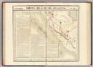
Partie, Sumatra. Oceanique no. 18.
1 : 1641836 Vandermaelen, Philippe, 1795-1869
Wegenkaart Zuid-Sumatra

Automobielkaart van Sumatra / Koninklijke Nederlandsch-Indische Motor Club, Semarang
Koninklijke Nederlandsch-Indische Motor Club Semarang Semarang : Koninklijke Nederlandsch-Indische Motor Club
Automobielkaart van Zuid-Sumatra / samengesteld en uitgegeven door de Koninklijke Vereeniging Java Motor Club
Koninklijke Vereeniging Java Motor Club Semarang Semarang : Koninklijke Vereeniging Java Motorclub
Overzichtskaartje Midden-Sumatra / Top[ografische] D[ienst]
Topografische Dienst Weltevreden (Batavia) Welt[evreden] (Batavia) : Repr[oductie] Bedr[ijf] Top[ografische] D[ienst]
Zuid-Sumatra

Automobielkaart van Noord-Sumatra / samengesteld en uitgegeven door de Koninklijke Vereeniging Java Motor Club
Koninklijke Vereeniging Java Motor Club Semarang Semarang : Koninklijke Vereeniging Java Motorclub
![[Doesoenpeloempat] / opgenomen door den Topografischen Dienst in 1924-1928 en 1932-1934](https://images-0.georeferencer.com/images/iiif/537212280081/full/,300/0/native.jpg)

