Maps of Bangka

[Bangka]
Topografische Dienst Batavia Batavia : Reproductiebedrijf Topografische Dienst
Kaart van den Riouw- en Lingga-Archipel / [J.W. Stemfoort en J.J. ten Siethoff ; gereproduceerd op last van het Departement van Koloniën, aan de Topographische Inrichting te 's-Gravenhage, onder leiding van den Directeur C.A. Eckstein]
Ministerie van Koloniën Den Haag s-Gravenhage : Departement van Koloniën
11. [Bangka, Blitoeng, Riouw- en Lingga-Archipel], uit: Atlas van Nederlandsch Oost-Indië / samengest. door Topographisch Bureau te Batavia van 1897-1904
Annotatie: Omgewerkte versie van: Atlas der Nederlandsche bezittingen in Oost-Indië / naar de nieuste bronnen samengest. door J.W. Stemfoort en J.J. ten Siethoff. - 's-Gravenhage : Topographische Inrichting, [ca. 1885] Topographisch Bureau, Batavia 's-Gravenhage : Topographische Inrichting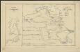
Het eiland Banka, 1819 [and] De rivier van Palembang, 1821
1 : 650000 Amsterdam : Wed. G. Hulst van Keulen
Geologische kaart van Bangka / naar de opnemingen der mijningenieurs en eigen onderzoekingen samengesteld door R.D.M. Verbeek
Amsterdam : Joh. G. Stemler
Schets-taalkaart van de Residentie Bangka / samengesteld door K.F. Holle, Adviseur-Honorair voor Inlandsche Zaken, naar gegevens verstrekt door de ambtenaren van Binnenlandsch Bestuur en met medewerking van het Topographisch Bureau te Batavia
Batavia : Topographisch Bureau
Banka : overzichtskaart der alluviale tinertsafzettingen en van de wegen / aut. C.J. van Doorne
[S.l. : s.n.]
A map of the island of Banca
1 : 200000 by M. H. Court R. Baily sculpt. London : Black, Kingsbury, Parbury & Allen
[Bangka]
Topografische Dienst Batavia Batavia : Reproductiebedrijf Topografische Dienst
[Djambi]
Topografische Dienst Batavia Batavia : Reproductiebedrijf Topografische Dienst
Res[identie] Bangka en Onderh[oorigheden] / Topografische Dienst, Batavia
[S.l. : s.n.]
Benkoelen / Survey of India
Survey of India [S.l.] : Survey of India
Kaart van den Archipel van Riouw, Singapore en Lingga [and] Kaart van de eilanden Bangka en Blitong
D. Heyse, graveur lith. te 's Hage ; gedr. bij P. Blommers te 's Hage te 's Hage : uitgave van K. Fuhri
Pangkalpinang / published by War Office = uitgegeven door War Office ; revised and photolithographed by War Office
War Office Washington D.C. [Washington D.C.] : War Office
Belinjoe / published by War Office = uitgegeven door War Office ; revised and photolithographed by War Office
War Office Washington D.C. [Washington D.C.] : War Office
Palembang / published by War Office = uitgegeven door War Office ; revised and photolithographed by War Office
War Office Washington D.C. [Washington D.C.] : War Office
Muntok / published by War Office = uitgegeven door War Office ; revised and photolithographed by War Office
War Office Washington D.C. [Washington D.C.] : War Office
Djambi / published by War Office = uitgegeven door War Office ; revised and photolithographed by War Office
War Office Washington D.C. [Washington D.C.] : War Office
Nipahpandjang / published by War Office = uitgegeven door War Office ; revised and photolithographed by War Office
War Office Washington D.C. [Washington D.C.] : War Office
Sekajoe / published by War Office = uitgegeven door War Office ; revised and photolithographed by War Office
War Office Washington D.C. [Washington D.C.] : War Office
Situatie van de A[jer] Poentian en Boedjang
[S.L. : s.n.]
[T[andjoen]g Tapah] : opgenomen door den Topografischen Dienst in 1917-1919
Topografische Inrichting Batavia Batavia : Topografische Inrichting
Kaart van een gedeelte van het Djambi-Rijk
Aardrijkskundig Genootschap Amsterdam Amsterdam : C.L. Brinkman
Simpangtiga / published by War Office = uitgegeven door War Office ; revised and photolithographed by War Office
War Office Washington D.C. [Washington D.C.] : War Office
Lahat / published by War Office = uitgegeven door War Office ; revised and photolithographed by War Office
War Office Washington D.C. [Washington D.C.] : War Office
Praboemoelih / published by War Office = uitgegeven door War Office ; revised and photolithographed by War Office
War Office Washington D.C. [Washington D.C.] : War Office
[P[oelau] Alang Gantang] : opgenomen door den Topografischen Dienst in 1915-1924
Topografische Inrichting Batavia Batavia : Topografische Inrichting
[Poelau] Banjak] / opgenomen door den Topografischen Dienst in 1915-1916
Topografische Dienst Batavia Batavia : Topographische Inrichting
[Psangmoendjoeng] / opgenomen door den Topografischen Dienst in 1924-1927
Topografische Dienst Batavia Weltevreden (Batavia) : Reproductiebedrijf Topografische Dienst
![[Bangka]](https://images-0.georeferencer.com/images/iiif/457701052870/full/,300/0/native.jpg)

