Maps of Lakonia Regional Unit
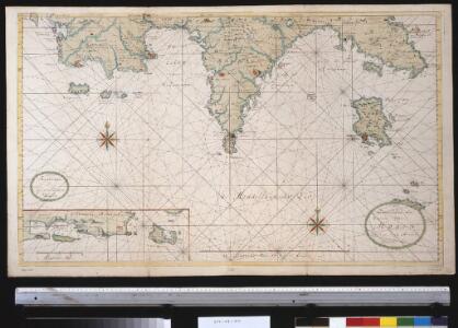
De zuijdelijkste zeekusten van Morea geleegen in de Middellandsche Zee
Greece Gerard van Keulen
Archipelagi Insularum Aliquot Descrip., [Cerigo] [Karte], in: Theatrum orbis terrarum, S. 246.
1 Karte aus Atlas Ortelius, Abraham
Cerigo Insul. [Karte], in: Gerardi Mercatoris Atlas, sive, Cosmographicae meditationes de fabrica mundi et fabricati figura, S. 523.
1 Karte aus Atlas Mercator, Gerhard Montanus, Petrus
Archipelagi Insularum Aliquot Descrip., [Cerigo] [Karte], in: Theatrum orbis terrarum, S. 341.
1 Karte aus Atlas Ortelius, Abraham Vrients, Jan Baptista
Porto St. Nicolo in I. Serigo
Greece Gerard van Keulen
Plan of the position of the allied squadrons and turkisch fleet in the action of the 20th Octr. 1827 at Navarino
1 : 30000 Pylos (Řecko) Officier of the Dartmouth Mollo, Tranquillo
Plan of the position of the allied squadrons and turkisch fleet in the action of the 20th Oct.r 1827 at Navarino
1 : 30000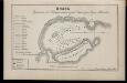
Plan sraženīja v Navarinskoj gubě, Oktjabrja 8go dnja 1827 goda
Griechenland Pylos Seeschlacht von Navarino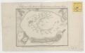
Stelling van de Geallieerde en Turksche eskaders in de haven van Navarino

Porto Serigo
Greece Gerard van Keulen
Versuch einer Topographie von Sparta und dessen umliegender Gegend
1 : 19400 Sparta (starověký řecký stát)

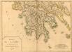
Morea olim Peloponnesus [Karte], in: Gerardi Mercatoris et I. Hondii Newer Atlas, oder, Grosses Weltbuch, Bd. 2, S. 333.
1 Karte aus Atlas Mercator, Gerhard und Hondius, Jodocus Jansson, Jan
Morea olim Peloponnesus. [Karte], in: Novus Atlas, das ist, Weltbeschreibung, Bd. 3, S. 344.
1 Karte aus Atlas Blaeu, Joan Blaeu, Willem Janszoon
MOREA | olim | PELOPONNESVS
Guilj. Blaeu exc.
Peloponnesus
Peloponnes Verwaltungsgliederung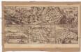
Coron
Koroni (Řecko) Zedtwitz, Curt Drda, Josef Jan Alois
Peloponnesus
1 : 1100000 Peloponés (Řecko) Metzeroth, Carl

Morea olim Peloponnesus
1 Karte : Kupferdruck ; 32 x 40 cm Hondius; Mercator Henricus Hondius
Morea olim Peloponnesus
1 Karte : Kupferdruck ; 32 x 40 cm Mercator s.n.
Messenia
1 : 640000 Messénie (Řecko) Barbié du Bocage, Jean Denis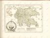
Carte de la Morée anciennement Peloponnèse, 1785
Carte de la Morée anciennement Peloponnèse, 1785. Gravé par L.A. Dupuis ... Lieues communes de France, 20[ = 128 mm] [Paris]
[General-Karte der Europaeischen Türkei und des Königreiches Griechenland]
1 : 864000 osmanská říše Scheda, Joseph von Artaria & Comp.
Ancient Greece : southern part
1 : 1500000 published under the superintendence of the Society for the Diffusion of Useful Knowledge engraved by J. & C. Walker London : Baldwin and Cradock
Turkey III : containing the southern part of Greece and Candia
published under the superintendence of the Society for the Diffusion of Useful Knowledge engraved by J. & C. Walker London : Baldwin and Cradock
Greece.
1 : 1480000 Mitchell, Samuel Augustus
Graecia
Schul-Atlas der alten Welt bei Justus Perthes