Maps of Kriti
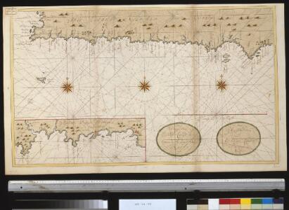
Een gedeelte vant eijland Candia vertoonende de Zuyd west kust
Greece Gerard van Keulen
Die Insel Candia oder Creta
1 : 500000 Kréta (Řecko : ostrov) Dietrich Reimer
[Nebenkarte Kreta] Ethnographische Karte der europäischen Türkei und ihrer Dependenzen zu Anfang des Jahres 1877
Griechenland Kreta Ethnische Gruppe Sax, Carl
Insvla di Candia del mare Mediteranea
Kréta (Řecko) Peeters, Jacob Lauwers, Conrad Ioannes Peeters
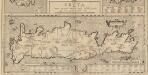
Candia
Mollova mapová sbírka Merian, Matthaeus Merian, Matthäus - dědici
Greece 1:250, 000, Khania
Greece 1:250,000 , Series GSGS 4410. Great Britain. War Office. [London] : War Office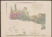
Carte orographique et géognostique de l'île de Crête
1 : 300000 Westblatt Raulin, Victor R. Janson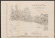
Carte orographique et géognostique de l'île de Crête
1 : 300000 Westblatt Raulin, Victor R. Janson
Candia cum insulis aliquot circa Græciam
1 Karte : Kupferdruck ; 22 x 46 cm, Bildgrösse 34 x 48 cm Mercator; Hondius Henricus Hondius
Candia cum insulis aliquot circa Græciam
1 Karte : Kupferdruck ; 22 x 46 cm, Bildgrösse 34 x 48 cm Mercator s.n.
Carte orographique et géognostique de l'île de Crête (H KPHTH)
1 : 300000 Westblatt Raulin, Victor R. Janson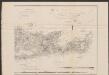
Carte orographique et géognostique de l'île de Crête
1 : 300000 Ostblatt Raulin, Victor R. Janson
Carte orographique et géognostique de l'île de Crête (H KPHTH)
1 : 300000 Ostblatt Raulin, Victor R. Janson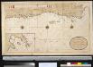
Een gedeelte van het eijland Candia vertoonende de Zuijd Oost zijden
Greece Gerard van Keulen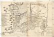
La parte di Sabionera attaccata da Tvrchi
1 : 4000 Kréta (Řecko) Bouttats, Gaspar
Candia
1 : 4200 Irákleio (Řecko) Bouttats, Gaspar
[Kreta Insel]
1 : 50000 Kréta (Řecko : ostrov) Verm-Abt.
Candia olim Creta
1 : 3830000 Kréta (Řecko)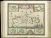
[83][83] Insula Candia ..., uit: Atlas sive Descriptio terrarum orbis
Annotatie: Gedigitaliseerde versie. Amsterdam. Heiloo : Picturae (vervaardiger), 2015. tiff-bestand. Gedigitaliseerd: 07-01-2015; Origineel: Universiteitsbibliotheek Vrije Universiteit (XL.05127.-) ; Netherlands; Titelpagina ontbreekt Wit, Frederik de Amsterdam : Frederick de Wit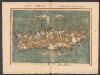
Tabula Neoterica Crete Sive Candie Insule [Karte], in: Claudii Ptolemei viri Alexandrini mathematice discipline philosophi doctissimi geographie opus [...], S. 281.
1 Karte aus Atlas Waldseemüller, Martin [und Ptolemaeus, Claudius] Übelin, Georg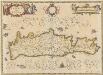
Candia olim Creta. [Karte], in: Novus atlas absolutissimus, Bd. 5, S. 294.
1 Karte aus Atlas Janssonius Offizin
CANDIA, | olim | CRETA
[Amsterdam : Joan Blaeu]
Creta Iovis magni, medio iacet insula ponto. [Karte], in: Theatrum orbis terrarum, S. 520.
1 Karte aus Atlas Ortelius, Abraham Vrients, Jan Baptista
Candia, olim Creta. [Karte], in: Novus Atlas, das ist, Weltbeschreibung, Bd. 3, S. 349.
1 Karte aus Atlas Blaeu, Joan Blaeu, Willem Janszoon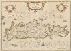
Candia, olim Creta. [Karte], in: Theatrum orbis terrarum, sive, Atlas novus, Bd. 3, S. 297.
1 Karte aus Atlas Blaeu, Joan Blaeu, Willem Janszoon
Candia cum Insulis aliquot circa Graeciam[:] [Zypern] [Karte], in: Gerardi Mercatoris Atlas, sive, Cosmographicae meditationes de fabrica mundi et fabricati figura, S. 493.
1 Karte aus Atlas Mercator, Gerhard Montanus, Petrus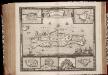
Insula Candia ejusque fortificatio / edita per F. de Wit
1 : 475000 Annotatie: Rechtsboven: 23; Origineel is Blad 173 in atlas factice; Annotatie geografische gegevens: Schaalstok: 15 Milliaria Germanica communia; Inzetkaarten van: Canea, Candia, Spina Longa, Retimo, Thine, Suda Frederick de Wit 1630-1706 Amsterdam : Gedruckt by Frederick de Wit inde Kalverstraet inde Witte Paskaert
Candia cum Insulis aliquot circa Graeciam[:] [Zypern] [Karte], in: Gerardi Mercatoris et I. Hondii Newer Atlas, oder, Grosses Weltbuch, Bd. 2, S. 336.
1 Karte aus Atlas Mercator, Gerhard und Hondius, Jodocus Jansson, Jan