Maps of Klützer Winkel
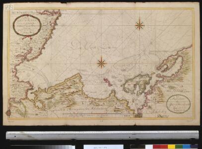
Nieuwe afteekening van een gedeelte van de Belt Zee daer in het in koomen van Wismar en de rivier van Lübeck geleegen aen de kust van Meekelen Burgh
Germany Johannes van Keulen
Nieuwe affteekening vande haven en stad Wismar met desselfs inkoomende zee gaten soo beoosten als bewesten Poel Eijland
Germany Gerard van Keulen
Composite: 84. Gromitz. (Germany)
1 : 100000 Reichsamt fur Landesaufnahme
84. Gromitz. (Germany)
1 : 100000 Reichsamt fur Landesaufnahme
Nieuwe Afteekening van de Haven en Stad Wismar met Desselfs Inkoomende zee Gaaten soo Beoosten als Beweste Poel Eyland en beleegering van dito Stad
1 : 65000 Mollova mapová sbírka Keulen, Gerard van Keulen, Gerard van
Ostsee
1 : 50000 Lübeck (Německo : oblast) Reichs-Marine-Amt
85. Kropelin. (Germany)
1 : 100000 Reichsamt fur Landesaufnahme
Accurater Abriss der Stadt und Festung Wismar.
1 : 50000 Mollova mapová sbírka Busch, Georg Paul Riediger, Johann Adam
Composite: 85. Kropelin. (Germany)
1 : 100000 Reichsamt fur Landesaufnahme
Particulier-Carte der Gegend Von Wismar nebst Der Insul Pöel und angedeuteter Bloquade zu Wasser und Lande 1715
1 : 45000 Mollova mapová sbírka Varenius, Heinrich Homann, Johann Baptista
Meßtischblatt 2035 : Neuburg, 1936
1 : 250000 Neuburg. - Hrsg. 1879, einz. Nachtr. 1919. - 1:25000. - [Berlin]: Reichsamt für Landesaufnahme, 1936. - 1 Kt.
Meßtischblatt 2034 : Kirchdorf, 1942
1 : 250000 Kirchdorf. - Aufn. 1877, hrsg. 1879, bericht. 1904, letzte Na. - 1:25000. - [Berlin]: Reichsamt für Landesaufnahme, 1942. - 1 Kt.
Meßtischblatt 665 : Kirchdorf, 1879
1 : 250000 Kirchdorf. - Aufn. 1877, hrsg. 1879. - 1:25000. - [Berlin]: Reichsamt für Landesaufnahme, 1879. - 1 Kt.
Meßtischblatt 2033 : Hohenkirchen (in Mecklenburg), 1934
1 : 250000 Hohenkirchen (in Mecklenburg). - Hrsg. 1877. - 1:25000. - [Berlin]: Reichsamt für Landesaufnahme, 1934. - 1 Kt.
Meßtischblatt 2032 : Kalkhorst, 1912
1 : 250000 Kalkhorst. - Hrsg. 1879, bericht. 1904, letzte Nachtr. 1912. - 1:25000. - [Berlin]: Reichsamt für Landesaufnahme, 1912. - 1 Kt.
Meßtischblatt 662 : Travemünde, 1879
1 : 250000 Travemünde. - Aufn. 1877. - 1:25000. - [Berlin]: Reichsamt für Landesaufnahme, 1879. - 1 Kt.
Meßtischblatt 582 : Russow, 1927
1 : 250000 Russow. - Hrsg. 1879, bericht. 1927. - 1:25000. - [Berlin]: Reichsamt für Landesaufnahme, 1927. - 1 Kt.
Meßtischblatt 581 : Kaltenhof (Insel Poel), 1927
1 : 250000 Kaltenhof (Insel Poel). - Hrsg. 1879, bericht. 1927. - 1:25000. - [Berlin]: Reichsamt für Landesaufnahme, 1927. - 1 Kt.
Meßtischblatt 1933 : Gr. Klütz - Höved, 1954
1 : 250000 Gr. Klütz - Höved. - Hrsg. 1879, bericht. 1904, redakt. Änd. 1954. - 1:25000. - [Berlin]: Reichsamt für Landesaufnahme, 1954. - 1 Kt.
Meßtischblatt 579 : Warnkenhagen, 1934
1 : 250000 Warnkenhagen. - Hrsg. 1879, bericht. 1904, einz. Nachtr. 1910. - 1:25000. - [Berlin]: Reichsamt für Landesaufnahme, 1934. - 1 Kt.
Meßtischblatt 578 : Rettin, 1879
1 : 250000 Rettin. - Aufn. 1877. - 1:25000. - [Berlin]: Reichsamt für Landesaufnahme, 1879. - 1 Kt.
Meßtischblatt 1835 : Rerik, 1939
1 : 250000 Rerik. - Hrsg. 1939. - 1:25000. - [Berlin]: Reichsamt für Landesaufnahme, 1939. - 1 Kt.
Meßtischblatt 503 : Alt- Gaarz, 1879
1 : 250000 Alt- Gaarz. - Aufn. 1877. - 1:25000. - [Berlin]: Reichsamt für Landesaufnahme, 1879. - 1 Kt.
Meßtischblatt502 : Klostersee, 1930
1 : 250000 Klostersee. - Hrsg. 1879, einz. Nachtr. 1930. - 1:25000. - [Berlin]: Reichsamt für Landesaufnahme, 1930. - 1 Kt.
Meßtischblatt 501 : Grömitz, 1889
1 : 250000 Grömitz. - Aufn. 1877, hrsg. 1879, einz. Nachtr. 1889. - 1:25000. - [Berlin]: Reichsamt für Landesaufnahme, 1889. - 1 Kt.
Stralsund
Stralsund (Německo)
Stralsund
Stralsund (Německo)
Stralsund
Stralsund (Německo)
Stralsund
Stralsund (Německo)