Maps of Troms

Skogkart paa grundlag av det Hydrografiske kart, blad 7
1 : 500000 Kaptein K. Gleditsch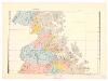
Spesielle kart 110-3: Hydrografisk kart over det nordlige Norge
1 : 500000 G. Sætren
Trigonometrisk grunnlag, Squelet-Cart 61
de Seue
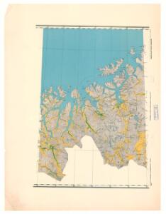
Statistikk 46-15: Bosettingskart over Norge
1 : 400000 Statistisk sentralbyrå
Tysk kart over Tromsø (Deutsche Heereskarte - Europa)
1 : 500000
Spesielle kart 122-14: Postkart over Norge
1 : 400000 Toralf à ̃yen
Statistikk 38-14: Bosettingskart over Finnmark og Troms. Blad 14
1 : 400000 Statistisk Sentralbyrå
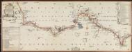
Museumskart 143: Kart over Den Norske Kyst fra Kvalø og Grøtsund til Sørøen
1 : 200000 Due | Rynning | Vibe | Hagerup
Geologiske kart 121-Æ: Kart med magnetisk totalfelt. Hammerfest
1 : 250000 Norges geologiske undersøkelse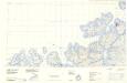
Statistikk 43-30- Bosettingskart over Hammerfest. Blad 30
1 : 250000 Statistisk Sentralbyrå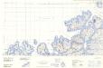
Statistikk 43-30-2: Bosettingskart over Hammerfest. Blad 30
1 : 250000 Statistisk Sentralbyrå
Museumskart 217-16: Kart over Den Norske Kyst fra Kvalø og Grøtsund til Sørøen
1 : 50000 Due | G. L. Fehr | Rynning | Vibe | Hagerup Opmaalings Directionen
Krokering nr 38-2
1 : 100000 Lund
Statistikk 38-13: Bosettingskart over Finnmark og Troms. Blad 13
1 : 400000 Statistisk Sentralbyrå
Spesielle kart 122-12: Postkart over Norge
1 : 400000 Toralf à ̃yen
Finmarkens amt 54c(1): Hammerfest med Maasà ̧ Præstegjeld
1 : 200000 Gerhard Munthe, Fredrik Rode
Statistikk 43-27- Bosettingskart over Nordreisa. Blad 27
1 : 250000 Statistisk Sentralbyrå
Statistikk 43-27-2: Bosettingskart over Nordreisa. Blad 27
1 : 250000 Statistisk Sentralbyrå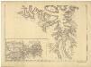
Statistikk 36-3 sør: Ethnigrafisk Kart over Finmarkens Amt No 3
1 : 200000 Jens Andreas Friis
Geologiske kart 121-Z: Kart med magnetisk totalfelt. Nordreisa
1 : 250000 Norges geologiske undersøkelse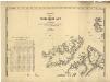
Statistikk 36-3 nord: Ethnigrafisk Kart over Finmarkens Amt No 3
1 : 200000 Jens Andreas Friis
Finmarkens amt 54a: HÃ¥ndtegnet kopi/skisse av Vestfjorden og Lofoten
1 : 200000 Fredrik Rode, Gerhard Munthe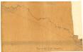
Finmarkens amt nr 53a: Kaafjord
1 : 20000 Fr. Löwenborg
NRA GA 19
Thodal | Wetterstedt | Holm | Marelius | Krogh | Halldin
Finmarkens amt 54d(4): Kautokeino og Karasjok Sogne
1 : 200000 Gerhard Munthe, Fredrik Rode
Krokering nr 72
1 : 200000 Lund
Museumskart 190: Kart ovèr den norske kyst fra söröen til nordkap
1 : 200000 Vibe
Museumskart 144: Kart over Den Norske Kyst fra Sørøen til Nordkap
1 : 200000 Klouman | Hagerup | Due | Vibe | Rynning
Museumskart 217-17: Kart over Den Norske Kyst fra Sørøen til Nordkap
1 : 50000 Due | Hagerup | Rynning | Vibe | Klouman | G. L. Fehr Opmaalings Directionen