Maps of Namsskogan

54C 12
1 : 50000 Gustav Heramd
1924-4 Röyrvik
1 : 50000 Norges Geografiske Oppmåling
1924-4 Røyrvik
1 : 50000 Statens kartverk
1924-4 Røyrvik
1 : 50000 Statens kartverk
54C Trones
1 : 100000
54C Trones
1 : 100000 C. Pedersen | Johan Gulbrandsen Natrud
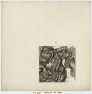
Geologisk kart 110: Trones
1 : 100000 Steinar Foslie Norges geologiske undersøkelse
1924-4 Röyrvik
1 : 50000 Norges Geografiske Oppmåling
54C Trones
1 : 100000 Johan Gulbrandsen Natrud | Johan Nordhagen
Geologisk kart 97: Trones
1 : 100000 Steinar Foslie Norges geologiske undersøkelse
54D 1; 54D 2; 54D 5; 54D 6; 54D 9; 54D 10
1 : 100000 Gustav Heramb
54C Trones
1 : 100000
Geologiske kart 46: Geologisk kart over den sydlige del av Børgefjeld og trakterne omkring Namsvand
1 : 200000 John Oxaal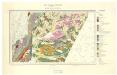
Geologisk kart 108: Namsvatnet med en del av Frøyningsfjell
1 : 100000 Steinar Foslie Norges geologiske undersøkelse
Liene
1 : 250000
Statistikk 43-18- Bosettingskart over Grogn. Blad 18
1 : 250000 Statistisk Sentralbyrå
Statistikk 43-18-2: Bosettingskart over Grong. Blad 18
1 : 250000 Statistisk Sentralbyrå
Statistikk 43-19- Bosettingskart over Mosjøen. Blad 19
1 : 250000 Statistisk Sentralbyrå
XVIII
1 : 400000 N. Franck
Spesielle kart 122-9: Postkart over Norge
1 : 400000 Toralf à ̃yen
Kartblad 73: Cartha over det Første Trundhiæmsche Regiments District
F. Klüwer
XVIII
1 : 400000 N. Franck
Statistikk 38-9: Bosettingskart over Norge. Blad 9
Statistisk Sentralbyrå
Kartblad 75: Situationskart over det Første Throndhiemske Infanteriregiments District
Hendrich Christoffer Eckleff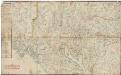
Kartblad 7 Carte over det 1. Trondhiemsche Regiment tillige med de 3 Nordenfi: Skieløber Compagniers Situation.
Isach Jørgen Coldevin
Kartblad 72: Cart over det Første Trondhiemsche Infanterie Regements Districhte
Bull
Det nordöstlige blad
1 : 600000 Norsko severní H. Aschehoug
Le royaume Norvége
1 : 2400000 Norsko
Skogkart paa grunnlag av det Hydrografiske kart, blad 4
1 : 500000 Kaptein K. Gleditsch