Maps of Lier

14D 10
1 : 50000 Lund
14D 10 nord
1 : 25000 Carl Olsen
14D 6 n/2; 14D 10 s/2
1 : 25000 Johannes Solem
14D 9
1 : 50000 Carl Aksel Sigurd Sissener
19B 1
1 : 50000 Carl Aksel Sigurd Sissener
1814-4 Lier
1 : 50000 Norges Geografiske Oppmåling
1814-4 Lier
1 : 50000 Statens kartverk
1814-4 Lier
1 : 50000 Statens kartverk
Spesielle kart nr 195. Kopi av kart over kullmilene på Krokskogen.
Conrad Clausen
14D Oslo
1 : 100000 Johan Gulbrandsen Natrud | Ole Engh
14D Oslo
1 : 100000 Johan Gulbrandsen Natrud | Ole Engh
Geologisk kart 118: The Aker Moraines
1 : 50000 J. Gjessing Norsk geografisk tidsskrift
14D Oslo
1 : 100000 Johan Gulbrandsen Natrud | Ole Engh
14D Oslo
1 : 100000 Johan Gulbrandsen Natrud | Ole Engh
14D Oslo
1 : 100000 Johan Gulbrandsen Natrud | Ole Engh
14D Oslo
1 : 100000 E. Heiberg | H. N. Bergh
Geologisk kart 1 Den geologiske undersøgelse, Rektangel 14D Kristiania
1 : 100000 Kjerulf Norges geologiske undersøkelse
14D 5
1 : 50000 Carl Aksel Sigurd Sissener
Kartblad 62: Cart over det Modumske Compagnie District
Niels Riis
Geologisk kart 102: Eiker
1 : 100000 Arne Bugge Norges geologiske undersøkelse
1814-4 Lier
1 : 50000 Norges Geografiske Oppmåling
1814-4 Lier
1 : 50000 Norges Geografiske Oppmåling
Kartblad 29: Militært Cart over det Askerske Compagnie District
M. Grønvold
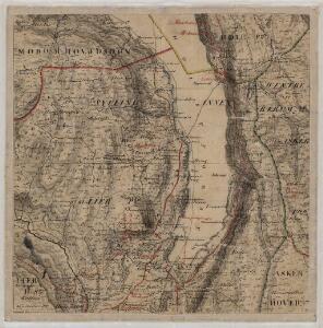
Kartblad 25: Cartt over det Lierske Infanterie Compagnies District
Christian Heubsch
1814-4 Lier
1 : 50000 Statens kartverk
Geologiske kart 50: Geologisk kart over Christiania omegn
1 : 100000 Theodor Kjerulf
1814-4 Lier
1 : 50000 Statens kartverk
F35-12, G35-7
1 : 50000 Nicolay Caspary Ræder
19B 2
1 : 50000 Kaare Kvisgaard | Oscar Thue | Hjalmar Skaar