Maps of Granvin herad

Kartblad 137-2: Situations Carte over den Nordre Hardangerske Compagnies...;b
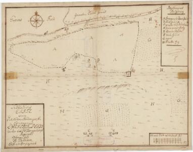
Jan Henrich Palludan
23B 1
1 : 50000 H. Lassen
23B 1
1 : 100000 W. Haffner
23B 1
1 : 50000 H. Lassen
C33-9; C33-10
1 : 50000 Gunvald Hagene
1316-2 Ulvik
1 : 50000 Norges Geografiske Oppmåling
1316-2 Ulvik
1 : 50000 Norges Geografiske Oppmåling
1316-2 Ulvik
1 : 50000 Statens kartverk
23B 2; 23B 5; 23B 6
1 : 50000 C. Smith
Kartblad 134-5: Cart over Wossiske Compagnie District; blad 5
Christopher Stenersen Collin
C32-1; C32-2; C32-3; C33-7; C33-8; C33-9
1 : 50000 Gunvald Hagene
C33-3; C33-4; C33-5; C33-6; C33-6; C33-9; C33-10; C33-11; C33-12
1 : 50000 Oscar Thue
1316-2 Ulvik
1 : 50000 Statens kartverk
1316-2 Ulvik
1 : 50000 Statens kartverk
C33 aust Ulvik
1 : 100000
Ulvikfjellene
1 : 100000 Finn Qvale | H. K. Hertzberg
C33 vest Voss
1 : 100000
C33 vest Voss
1 : 100000
C33 aust Ulvik
1 : 100000
Kart over Ulvikfjellene m. m.
1 : 100000 H. K. Hertzberg | Finn Qvale
Geologiske kart 63: Den geologiske Undersøgelse, Voss
1 : 100000 J. Natrud Norges geologiske undersøkelse
23A Voss
1 : 100000 Johan Gulbrandsen Natrud
Portefølje nr 36
1 : 100000 H. Lund
Portefølje nr 28
1 : 100000 F. Sejersted | E. Lund
C33-4; C33-5; C34-10; C34-11
1 : 100000 Johannes Oliver Smith
Kroki over en del av Haringvidda
1 : 100000 Finn Qvale
Museumskart 217-42: Specialkart over Hardangerfjorden. Østre del.
1 : 100000 M. T. Kingo | R. M. Petersen | H. N. Bergh Den Geografiske Opmaaling
Kartblad 132- Situation af det Urlandske Compagnie District; versjon 1
Leitzner
Kartblad 132-2: Situation af det Urlandske Compagnie District; versjon 2
Leitzner