Maps of Andalucía

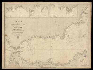
Spain, South coast form Gibraltar to Alicante, and north coast of Barbary to cape Ferrat, from Spanish authorities, with corrections by Capt. W.H.Smyth. The north coast of Africa is from French surveys of 1833-55.
Walker, J. & C.
Granata, Et Murcia Regna. [Karte], in: Theatrum orbis terrarum, sive, Atlas novus, Bd. 2, S. 234.
1 Karte aus Atlas Blaeu, Joan Blaeu, Willem Janszoon
Granata, Et Murcia Regna. [Karte], in: Gerardi Mercatoris et I. Hondii Newer Atlas, oder, Grosses Weltbuch, Bd. 2, S. 198.
1 Karte aus Atlas Mercator, Gerhard und Hondius, Jodocus Jansson, Jan
Granata, Et Murcia Regna. [Karte], in: Novus atlas absolutissimus, Bd. 6, S. 46.
1 Karte aus Atlas Janssonius Offizin
Granata, Et Murcia Regna. [Karte], in: Le théâtre du monde, ou, Nouvel atlas contenant les chartes et descriptions de tous les païs de la terre, Bd. 2, S. 227.
1 Karte aus Atlas Blaeu, Willem Janszoon und Blaeu, Joan Blaeu, Willem Janszoon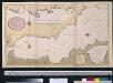
Een gedeelte van de Middelanse Zee van Gibraltar tot Ivica
Spain Gerard van Keulen
Granata, Et Murcia Regna. [Karte], in: Novus Atlas, das ist, Weltbeschreibung, Bd. 2, S. 234.
1 Karte aus Atlas Blaeu, Joan Blaeu, Willem Janszoon

GRANATA, | ET | MVRCIA | REGNA.
[Amsterdam : Joan Blaeu]
Granata, et Mvrcia regna
1 Karte : Kupferdruck ; 36 x 48 cm Janssonius Joannes Janssonius
Granata, et Mvrcia regna
1 Karte : Kupferdruck ; 36 x 48 cm Blaeu Joan Blaeu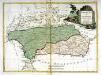
Andalusia et Granada
1 Karte : Kupferdruck ; 28 x 38 cm Zatta presso Antonio Zatta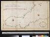
De Middellandsche Zee van Gibralter tot Algiers
Spain Gerard van Keulen
43. Spagna, Portogallo sud.
1 : 1500000 Touring club italiano
Neueste Generalkarte von Portugal und Spanien, 5
1 Blatt : 70 x 50 cm Schrämbl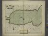
A chart of the sea coast of SPAIN from the Straits mouth to C de Gat and of the sea coast of BARBARY from the Straits mouth to C de Hone
from The sea-atlas : containing an hydrographical description of most of the sea-coasts of the known parts of the world.
Regnorum Castellæ veteris Legionis et Gallæciæ principatuumque Biscaiæ et Asturiarum accuratissima descriptio, 5
1 Blatt : 54 x 41 cm Visscher
Parte meridional de las costas d'Españas
1 Karte auf 2 Blättern : Kupferdruck ; 53 x 82 cm López; Nolin; Guérard; Julien en casa de Thomas Lopez pensionista de s. m. c.a, chez le s.r Julien a l'hotel de Soubise
Spain, Portugal 3.
1 : 1774080 Letts, Son & Co.
Andaluziae Nova Descript. [Karte], in: Gerardi Mercatoris Atlas, sive, Cosmographicae meditationes de fabrica mundi et fabricati figura, S. 186.
1 Karte aus Atlas Mercator, Gerhard Montanus, Petrus
Andaluziae Nova Descript. [Karte], in: Gerardi Mercatoris et I. Hondii Newer Atlas, oder, Grosses Weltbuch, Bd. 2, S. 204.
1 Karte aus Atlas Mercator, Gerhard und Hondius, Jodocus Jansson, Jan
Andaluziae Nova Descript. [Karte], in: Gerardi Mercatoris et I. Hondii Newer Atlas, oder, Grosses Weltbuch, Bd. 1, S. 247.
1 Karte aus Atlas Mercator, Gerhard und Hondius, Jodocus Jansson, Jan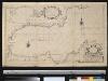
Carte particuliere des côstes d'Espagne et Barbarie depuis Gibralter jusqu'à C. de Palle et depuis Ceuta jusqu'au C. Ferat
Spain Henri Michelot Gerard van Keulen
Granatae regnv[m]
1 Karte : Kupferdruck ; 15 x 23 cm Lambert Andreae
[Carte d'Espagne et de Portugal en neuf feuilles, 8]
1 Blatt : 31 x 41 cm P.G. Chanlaire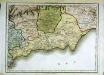
Espagne et Portugal, 8
1 Blatt : 31 x 42 cm Mentelle

Granadæ, Cordovæ et Gienensis regna
1 Karte : Kupferdruck ; 43 x 56 cm López; Güssefeld apud Homannianos Heredes

Andaluzia
1 Karte : Kupferdruck ; 17 x 24 cm Mercator; Keere Cloppenburgh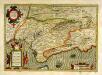
Andaluziæ nova descript
1 Karte : Kupferdruck ; 34 x 49 cm Mercator; Hondius; Hondius Henricus Hondius