Maps of Kladno

Podrobné mapy zemí Koruny české v měřítku 1:75.000 - Smečno - Kladno - Unhošť. Průvodce statisticko-historický po všech místech na těchto mapách uvedených a rejstřík věcný názvů hor, potoků, řek, rybníků atd. a mapa vzdáleností všech míst při silnici ležících Sešit 4. List 41,
1 : 75000
Soubor přehledných map pro plánování a statistiku: 3952 – Kladno

Soubor přehledných map pro plánování a statistiku: 3952 – Kladno

III. vojenské mapování 3952
1 : 75000
Karte des Gemeindegrenzen

Podrobná mapa okolí Pražského
1 : 75000 Kladno (Česko : oblast) Hevera, Čeněk Obec pražská
Podrobná mapa okolí Pražského List I.

Kladno und Schlan
1 : 75000 Kladno (Česko : oblast) Irblich K. u. k. militär-geographisches Institut
Kladno und Schlan
1 : 75000 Kladno (Česko : oblast) Irblich K. u. k. Militärgeographisches Institut
Kladno und Schlan
1 : 75000 Kladno (Česko : oblast) K. u. k. Militärgeographisches Institut
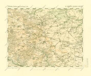
Kladno
1 : 75000 Kladno-oblast (Česko) Vojenský zeměpisný ústav
Kladno
1 : 75000 Kladno (Česko : oblast) Vojenský zeměpisný ústav
Slanský vikariát
Slaný-oblast (Česko)
Karte des Unhoschter Bezirkes im Prager Kreise
1 : 70000 Unhošť-oblast (Česko) Wagner, Jan Eduard Karl André
III. vojenské mapování 3952/4
1 : 25000
III. vojenské mapování 3952/4
1 : 25000
Gradkartenblatt
1 : 25000 Unhošť-oblast (Česko) Albrecht, Julius
PLAN DES Tuchomeirzitzer, Cizoniczer, Strzedokluker und Russiner Revieres
1 : 3000 Tuchoměřice (Česko)
Situation des Waldstandes der Domaine Pürglitz in der Revieren Potepl, Chiňava, Běleč, Ploskov und Lána.
Křivoklát-oblast (Česko) Braun, Georg Jelínek, J. J. Jelínek
Mapa okolí Svárovského a Nučického mezi Prahou a Berounem

Chiniawa - c2714-1-010 - Kaiserpflichtexemplar der Landkarten des stabilen Katasters
1 : 2880
Chiniawa - c2714-1-002 - Kaiserpflichtexemplar der Landkarten des stabilen Katasters
1 : 2880
Chiniawa - c2714-1-013 - Kaiserpflichtexemplar der Landkarten des stabilen Katasters
1 : 2880
Chiniawa - c2714-1-001 - Kaiserpflichtexemplar der Landkarten des stabilen Katasters
1 : 2880
Chiniawa - c2714-1-006 - Kaiserpflichtexemplar der Landkarten des stabilen Katasters
1 : 2880
Chiniawa - c2714-1-012 - Kaiserpflichtexemplar der Landkarten des stabilen Katasters
1 : 2880
Chiniawa - c2714-1-007 - Kaiserpflichtexemplar der Landkarten des stabilen Katasters
1 : 2880
Chiniawa - c2714-1-009 - Kaiserpflichtexemplar der Landkarten des stabilen Katasters
1 : 2880
Chiniawa - c2714-1-014 - Kaiserpflichtexemplar der Landkarten des stabilen Katasters
1 : 2880
Chiniawa - c2714-1-008 - Kaiserpflichtexemplar der Landkarten des stabilen Katasters
1 : 2880
Chiniawa - c2714-1-005 - Kaiserpflichtexemplar der Landkarten des stabilen Katasters
1 : 2880
Chiniawa - c2714-1-003 - Kaiserpflichtexemplar der Landkarten des stabilen Katasters
1 : 2880
Chiniawa - c2714-1-004 - Kaiserpflichtexemplar der Landkarten des stabilen Katasters
1 : 2880