Maps of Camden
Plan of the city of Philadelphia and Camden
1 : 25000 Gamble, W. H. (William H.) S. Augustus Mitchell Jr.
Plan of the city of Philadelphia and Camden
1 : 25000 Gamble, W. H. (William H.) Wm. M. Bradley & Bro.
Philadelphia.
1 : 20000 Colton, G. Woolworth
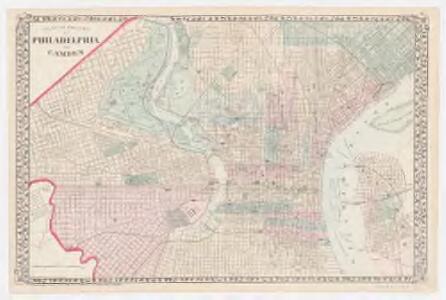
Plan of the City of Philadelphia and Camden
1 : 25000 Mitchell, Samuel Augustus Jr.
Barnes' map of Philadelphia : built portion of the city
Barnes, Rufus L J.L. Smith
Philadelphia visitor's companion
from Philadelphia
Rand McNally new commercial atlas map of Philadelphia
1 : 20300 Rand McNally and Company Rand McNally & Co.
Philadelphia.
1 : 31000 Johnson, A.J.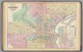
Philadelphia, Camden.
1 : 19800 Gray, Ormando Willis; Walling, H. F.
Plan of the city of Philadelphia / compiled from actual survey by J. Drayton.
from Philadelphia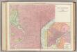
Philadelphia.
1 : 19100 Rand McNally and Company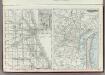
Philadelphia and Chicago.
Rand McNally and Company
Plan von Philadelphia
1 : 36000 Filadelfie (Pensylvánie) Metzeroth, Carl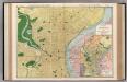
Philadelphia.
1 : 20000 Rand McNally and Company
Philadelphia / M. H. Traubel sct.
from Philadelphia
Plan of Philadelphia.
from Mitchell's new general atlas, containing maps of the various countries of the world, plans of cities, etc., embraced in fifty-three quarto maps., forming a series of eighty four maps and plans, together with valuable statistical tables.
Philadelphia.
from Philadelphia
Philadelphia and environs.
from The American traveller ; or, Guide through the United States, containing brief notices of the several states, cities, principal towns, canals and rail roads, etc. ; with tables of distances by stage, canal and steam boat routes ... by H.S. Tanner.
Philadelphia and environs.
from The American traveller; or, Guide through the United States. Containing brief notices of the several states, cities, principal towns, canals and rail roads, etc. With tables of distances, by stage, canal and steam boat routes. The whole alphabetically arranged, with direct reference to the accompanying map of the roads, canals and railways of the United States. By H.S. Tanner.
Philadelphia
1 : 24000
Philadelphia
1 : 24000
Philadelphia
1 : 24000
Philadelphia
1 : 24000
Philadelphia
1 : 24000
Philadelphia
1 : 24000
Philadelphia
1 : 24000
Philadelphia
1 : 24000
Philadelphia
1 : 24000
Philadelphia.
from Philadelphia