Maps of Balkan Pen.

Die Staaten von Südost=Europa : Rumänien, Serbien, Montenegro, Bulgarien, Kreta, Europ. Türkei, Griechenland
1 : 3000000 Peucker, Karl, 1859-1940 Artaria
Mapa rakousko-srbského bojiště
1 : 2000000 Balkánský poloostrov V. Neubert
Mapa rakousko-srbského bojiště
1 : 2000000 Balkánský poloostrov Machát, František V. Neubert
Poloostrov Balkánský
1 : 2750000 Balkánský poloostrov Machát, František J. Otto
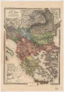
Karten zum russisch-türkischen Krieg 1877-1878. Europäische Türkei und Balkanstaaten bis zum Kriegsende
1 : 6000000 Balkanhalbinsel Russisch-Türkischer Krieg <1877-1878>
Karten zum russisch-türkischen Krieg 1877-1878. Europäische Türkei und Balkanstaaten nach dem Berliner Kongress
1 : 6000000 Balkanhalbinsel Russisch-Türkischer Krieg <1877-1878> , Berliner Kongress
Jeviště východní otázky.
Evropa jihovýchodní Berthe, L. Karl Wilhelm Ferdinand Brunšvický
Ethnog. Balkan Peninsula, Constantinople, Sea of Marmara.
1 : 6000000 Andree, Richard; Times (London, England)
Die Staaten der Balkan - Halbinsel

Graecia Antiqua.
1 : 2250000 Playfair, Principal
Der griechisch-türkische Handel im 18. und beginnenden 19. Jh.
Griechenland, Osmanisches Reich, Handel
Die europäische Türkei mit dem Schutz-Fürstenthümern, das Königreich Griechenland, und die Republik der Sieben Ionischen Inseln (unter Britischen Schutze)
1 : 6200000 Balkánský poloostrov Kiepert, Heinrich Herzberg, H. Geographisches Institut
Turkey in Europe.
1 : 5950000 Lucas, Fielding Jr.
Europäische Türkei Griechenland u.d. Ionischen Inseln
Balkanhalbinsel Skizzenbuch
Turkey and Greece.
1 : 3380000 Sharpe, J.
Turquie d'Europe.
1 : 3500000 Brue, Adrien Hubert, 1786-1832
Turkey in Europe.
1 : 2500000 Arrowsmith, John
Europäische Türkei von 1812-1878
1 : 15000000 Osmanisches Reich / Europäischer Teil
Turkey in Europe.
1 : 1964160 Rand McNally and Company
Volkerkarte Balkanhalbinsel, Konstantinopel, Marmarameer.
Andree, Richard
Europäische Türkei seit 1878
1 : 15000000 Balkanhalbinsel, Osmanisches Reich
Turquie D'Europe et Grece.
1 : 3900000 Montemont, A.
Europaeische Türkey
1 : 5550000 Turecko
Europaeische Türkey
1 : 5550000 Evropa jihovýchodní
Turkei u. Griechenland.
1 : 3000000 Stein, Christ. Gottfr. Dan.
[Europ. Türkey und Griechenland]
[Allgemeiner Atlas über alle Theile der Erde in 29 Blättern] Ziegler, Jakob Melchior Top. Anstalt v. J. Wurster u. Comp.
Europaeische Turkey u. Griechenland.
1 : 3000000 Ziegler, J. M.
Turkey in Europe.
1 : 3800000 Teesdale, Henry
Poloostrov Balkánský