Maps of Milwaukee

Map of the city of Milwaukee : engraved from original drawings & surveys
Chapman, Silas published for by [sic] Silas Chapman
Milwaukee.
1 : 24000 Rand McNally and Company
Map of Milwaukee
1 : 7920 Lapham, Increase Allen, 1811-1875 engraved Sherman & Smith
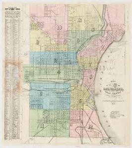
Map of the city of Milwaukee
1 : 20000 C.N. Caspar Co C.N. Caspar Co. Publishers
Milwaukee
1 : 24000
Milwaukee
1 : 24000
Milwaukee
1 : 24000
New edition map of City of Milwaukee and suburbs
1 : 25000 This map is attached to a cover. Streets, points of interest, the Milwaukee River, and Lake Michigan are labeled. The bottom margin of the map includes a street index. A section of downtown located on the middle right of the map has been trimmed off and marked with manuscript annotations in red showing churches. Siekert and Baum Stationery Co. T.M.E.R. & L. Co.
Milwaukee and vicinity, Wisconsin, 1959
1 : 24000 Geological Survey (U.S.) U.S. Dept. of the Interior, Geological Survey
Milwaukee
1 : 62500
Milwaukee
1 : 62500
Milwaukee
1 : 62500
Milwaukee
1 : 62500
Milwaukee
1 : 62500
Milwaukee
1 : 62500
Milwaukee
1 : 62500
Milwaukee
1 : 62500
Milwaukee
1 : 62500
Milwaukee
1 : 62500
Map of the county of Milwaukee, Wisconsin
1 : 31680 Walling, Henry Francis, 1825-1888 M.H. Tyler
Shell Metropolitan Milwaukee and Vicinity.
1 : 110880 Shell Oil Company
Section 1. Bicycle Road Map of Wisconsin.
1 : 253440 League of American Wheelmen, Wisconsin Division
Map of Racine and Kenosha counties, State of Wisconsin.
1 : 126720 Snyder, Van Vechten & Co.
Chicago District.
1 : 380000 Rand McNally and Company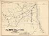
Fox River Valley R.R. in Wisconsin with its connections.
1 : 1600000 This hand colored map shows southern Wisconsin and northern Illinois and indicates county boundaries, larger cities, and some drainage. The line was chartered in 1852 and constructed in 1854. Lipman & Riddle Lipman & Riddle Lith
Wisconsin S. part.
1 : 780000 Morse, Sidney E. (Sidney Edwards), 1794-1871
Triangulation in Wisconsin
1 : 506880 This map shows names of triangulation stations, railroads, counties, rivers, and lakes. The Mississippi River, Lake Winnebago, and Lake Michigan are labeled. The upper right corner includes a key of markings. The map covers north to Eau Claire. Davies, John Eugene Wisconsin Geological Survey
Wisconsin.
1 : 1340000 Mitchell, Samuel Augustus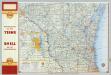
Shell Highway Map of Wisconsin (northern portion).
1 : 950400 Shell Oil Company