Maps of South Carolina

South-Carolina and parts adjacent : shewing the movements of the American and British armies
1 : 1025000 Collins, Isaac, 1746-1817 Isaac Collins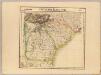
Partie des Etats Unis. Amer. Sep. 57.
1 : 1641836 Vandermaelen, Philippe, 1795-1869
South Carolina.
1 : 1275000 Colton, G.W.
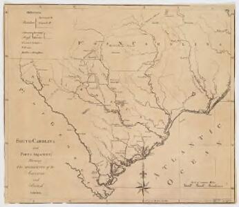
The State of South Carolina, from the bests authorities.
from Carey's general atlas, improved and enlarged : being a collection of maps of the world and quarters, their principal empires, kingdoms, &c.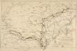
Map showing Route of Marches of the Army of Genl. W. T. Sherman from Atlanta, Ga. to Goldsboro, N. C. [Scale,] 50 st. miles[= 40 mm]
Map showing Route of Marches of the Army of Genl. W. T. Sherman from Atlanta, Ga. to Goldsboro, N. C.. Produced by the Engineer Bureau of the Union War Department, a Map Showing Route of Marches of the Army of General W.T. Sherman from Atlanta, GA to Goldsboro, N.C., details Sherman’s March through the South. The coloured lines indicate the regiments involved and the routes through Georgia, South Carolina and North Carolina which they took. Sherman’s success in these regions helped bring a large proportion of the Deep South under Union control from the autumn of 1864 onwards. War Department
[Neueste Karte von Süd Carolina mit seinen Canaelen, Strassen, Dampfschiff Routen und Entfernungen der Hauptpunkte]
Grosser Hand-Atlas über alle Theile der Erde in 170 Karten Meyer, J. Verlag des Bibliographischen Instituts
Composite: Map Of South Carolina
1 : 380160 Wilson, John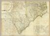
Composite: North & South Carolina.
1 : 530000 Jefferys, Thomas
South Carolina.
1 : 2012000 Colton, G. Woolworth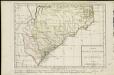
Carte des deux Carolines et de la Géorgie
1 : 2800000 Hilliard d'Auberteuil, Michel René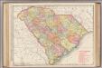
South Carolina.
1 : 760000 Rand McNally and Company
South Carolina.
Rand McNally and Company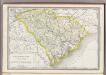
South Carolina.
1 : 1180000 Rand McNally and Company
S. Carolina.
1 : 1520000 Cram, George Franklin; Davis, Ellis Arthur
N. & S. Carolina.
1 : 2400000 Mitchell, Samuel Augustus
N. & S. Carolina.
1 : 2400000 Mitchell, Samuel Augustus
N. & S. Carolina.
1 : 2400000 Mitchell, Samuel Augustus Jr.
N. & S. Carolina.
1 : 2400000 Mitchell, Samuel Augustus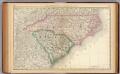
North and South Carolina.
1 : 2100000 Rand McNally and Company
North and South Carolina.
1 : 1330560 Cram Atlas Company
N. & S. Carolina.
1 : 2500000 Mitchell, Samuel Augustus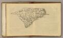
(N Carolina, S Carolina)
1 : 4200000 Moore, M. B. (Marinda Branson), 1829-1864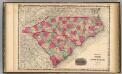
North And South Carolina.
1 : 1584000 Johnson, A.J.
North and South Carolina.
1 : 2500000 Greenleaf, Jeremiah
North and South Carolina.
1 : 2724480 Greenleaf, Jeremiah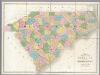
Map of North And South Carolina.
1 : 633600 Burr, David H., 1803-1875
North and South Carolina.
1 : 2661120 Burr, David H., 1803-1875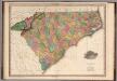
Map of North & South Carolina.
1 : 1100000 Tanner, Henry S.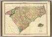
Map Of North & South Carolina.
1 : 1140480 Tanner, Henry S.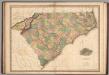
Map of North & South Carolina.
1 : 1100000 Tanner, Henry S.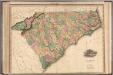
Map of North & South Carolina.
1 : 1100000 Tanner, Henry S.