Maps of Mediterranean Sea

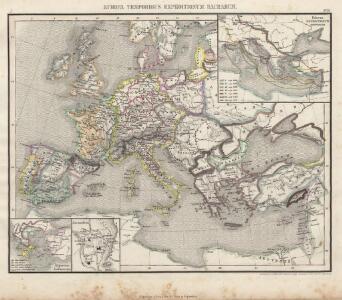
Europa Temporibus Expeditionum Sacrarum
Europa Kreuzzüge
Paasche's Frontenkarte, Nr. 11 Europäische Kriegsschauplätze

Napoleons Heereszüge : von seinem Auftreten als Ober-General der Armee von Italien 1796 bis zu seiner Thron-Entsagung nach der Schlacht bey Waterloo 1815
Entworfen von F.W. Benicken gravirt v. C. Halle Weimar : im Verlage des Landes Industrie-Comptoirs
Říše římská v době největší své rozsáhlosti


Österreich-Ungarn und Bosnien-Hercegovina
Eberle, Joseph
Europa 1993
Europa Kunz, Andreas ; Moeschl, Joachim Robert
Europa zu Anfang des 6ten Jahrhunderts
Europa Völkerwanderung
Roman Empire, Greece.
1 : 17000000 Mitchell, Samuel Augustus
Théatre de la guerre actuelle, en Allemagne, en Pologne et en Turquie. Carte de l'Europe méridionale en 53 feuilles qui se réunissent. Tableau d'assemblage indiquant la disposition de ces feuilles, pour en faciliter la réunion
1 : 28500000 Chanlaire, Pierre Grégoire 1758-1817 Paris : chez l'auteur P. G. Chanlaire

Europa 1964
Europa Kunz, Andreas ; Moeschl, Joachim Robert
Overland Route To India.
1 : 24000000 Tallis, J. & F.
Eisenbahn- Post- und Dampfschiffahrts-Karte von Europa
1 : 8000000 Evropa Denk, L. Lith. Anst. v. L. Mohn's Witwe
Europa 1820
Europa Kunz, Andreas ; Röss, Wolf ; Moeschl, Joachim Robert
Kriegszusammenhänge II (1672-1699)
1 : 25000000 Europa Englisch-Niederländischer Seekrieg <1672-1674>, Türkenkriege
L'Empire Grec au temps de Justinien (VI.e siècle)
Byzantinisches Reich Justinian I.
Europa 1908
Europa Kunz, Andreas ; Röss, Wolf ; Moeschl, Joachim Robert
Evropa za stěhování národů

Europa 1975
Europa Kunz, Andreas ; Moeschl, Joachim Robert
Europa 2007
Europa Kunz, Andreas ; Moeschl, Joachim Robert
Europa 1772
Europa Kunz, Andreas ; Moeschl, Joachim Robert
Europa zur Zeit der Kreuzzüge
Europa, Byzantinisches Reich, Kreuzzüge
Europa 1929
Europa Kunz, Andreas ; Moeschl, Joachim Robert
Europa 1937
Europa Kunz, Andreas ; Moeschl, Joachim Robert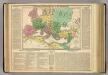
Roman Empire.
1 : 13400000 Lavoisne, M.
Politieke kaart van Midden Europa 1939 : met aanduiding van de nieuwste grenzen, bijzonderste steden, stroomen en rivieren, spoorwegen, luchthavens, enz.
1 : 4300000 Annotatie: Met demografische en politiek-economische gegevens [Antwerpen] : Patria [etc.]
Europa 6.8.1806
Europa Kunz, Andreas ; Moeschl, Joachim Robert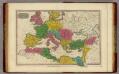
Romanum Imperium.
1 : 13000000 Finley, Anthony