Maps of Europe

Charte von Europa
Europa
Oro-Hydrographische Charte von Europa
Europa Orohydrografie
Neubertova podrobná politická mapa Evropy

Europa
Volksschul-Atlas über alle Teile der Erde Lange, Henry Druck und Verlag von Georg Westermann
Europa

Versuch einer Übersicht der geographischen Verbreitung der Gewitter
Erster Band, enthaltend in vier Abtheilungen die Erscheinungen der anorganischen Natur: 1. Meteorologie und Klimatographie. 2. Hydrologie und Hydrographie. 3. Geologie. 4. Tellurischer Magnetismus Humboldt, Alexander von Verlag von Justus Perthes
[Recto], uit: Europa / [aardrijkskundig medew. G.J. de Vries]
1 : 25000000 titelvariant: Landen van Europa met de hoofdsteden; Annotatie: Titel boven de krt.: Landen van Europa met de hoofdsteden; Verso: register van landen met de hoofdsteden Gerben Johannes de Vries 1886-1968 Sneek : Tonnema & Cie
Politický přehled Evropy

Europe relief du sol
Vidal de La Blache, Paul
Europa, Fluss- und Gebirgskarte
1 : 24000000 Europa Physische Geografie

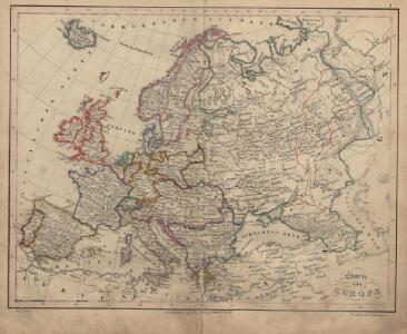
Europa mit Berücksichtigung der Veränderungen von 1815 - 1870
Europa
Neue Wandkarte von Europa

Europe relief du sol
Vidal de La Blache, Paul
Europa 2003 [Blattschnitt bis zum Ural]
Europa Kunz, Andreas ; Moeschl, Joachim Robert
Evropa

Carte générale orographique et hydrographique de l'Europe, qui montre les principales ramifications des montagnes, fleuves et chemins avec les principales villes
1 : 4600000 dressée d'aprés les meilleures cartes des auteurs les plus acredités par le Général Baron Sorriot de L'Host gravée par Joseph List. Vienne, [s.n.]
Imperium Romanorum inde a Constantini Magni tempore.
1 : 15500000 Menke, Th.
Europa
1 : 14000000 Evropa C. Flemming
Religionskarte von Europa
1 : 23500000 Europa Denomination
Charte von Europa mit der Nordküste von Africa und einen grossen Theile von Asien
1 : 9000000 Afrika severní Marco Berra
Accuratissima Europæ tabula
1 Karte : Kupferdruck ; 48 x 56 cm Wit; Ottens; Ottens ex officina R. et I. Ottens
Nova et accurata totius Europæ delineatio vulgata
1 Karte : Kupferdruck ; 48 x 56 cm Sandrart Jakob von Sandrart
Carte pittoresque & maritime de l'Europe : indiquant la division des Etats, les routes et chemins de fer ... / par A.M. Perrot ; revue et augm. par A. Vuillemin
1 : 5700000 Annotatie: Met afb. van de belangrijkste Europese steden en diverse kostuumfiguren; Annotatie geografische gegevens: Grenzen gekleurd Perrot, A. M.; Vuillemin, A. Paris : Fatout
Europe au Xe Siecle.
1 : 20500000 Monin, C.V.
Ewropa
1 : 32000000 Evropa Merklas, Václav
Karte der Verbreitungsgebiete der Religionen in Europa
1 : 7500000 Evropa Hickmann, Anton L. Freytag & Berndt
Europa nach dem Weltkriege
1 : 7500000 Evropa Carl Flemming und C. T. Wiskott Aktiengesellschaft für Verlag und Kunstdruck
Politická mapa Evropy
1 : 15000000 Evropa Wolf, R.