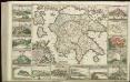
Maps of Peloponnese, West Greece and Ionian Sea

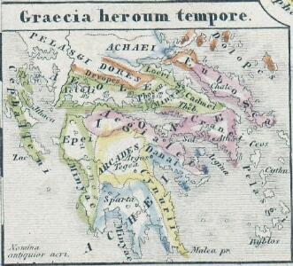
Graecia heroum tempore
Griechenland, Mittelmeerraum, Antike
Greece.
1 : 1140480 Letts, Son & Co.
[Historisch-geographischer Atlas zu den allgemeinen Geschichtswerken von C. v. Rotteck, Pölitz u. Becker] : Alt Griechenland
von Julius Loewenberg [Freiburg im Breisgau] : [Herder]
Alt Griechenland
Athény-oblast (Řecko) Loewenberg, Julius Kt., I. V.
Greece and the Ionian Islands.
1 : 1110000 Sharpe, J.
Řecko
starověké Řecko Bodenehr, Gabriel Sharland, William Karel André
Greece.
1 : 917000 Johnston, Alexander Keith
Schul-Atlas für die alte Erdbeschreibung : zur allgemeinen Schul-encyclopädie gehörig
J. H. Campe Zusammensetzung und Zeichnung von [...] Dufour, unter Leitung von Heusinger ; gestochen von Frentzel. Braunschweig : Schulbuchhandlung
Morea
Řecko Müller, Jos. D. Šafařík, Pavel Josef

Greece.
1 : 1470000 Tanner, Henry S.
Greece.
1 : 917000 Johnston, Alexander Keith, 1804-1871
Greece.
1 : 1500000 Tanner, Henry S.
Greece.
1 : 1500000 Tanner, Henry S.
Griechenland.
1 : 1600000 Meyer, Joseph, 1796-1856
Greece.
1 : 917000 Johnston, Alexander Keith
Peloponnesus; sive Morea. [Karte], in: Novus atlas absolutissimus, Bd. 10, S. 176.
1 Karte aus Atlas Janssonius Offizin
Hellas
1 : 1680000 Athény (Řecko) Kiepert, Heinrich Kratz, W. Geographisches Institut
Regnum Moreae accuratissime divisum in provincias Saccaniam, Tzaconiam, Caliscopium et ducatum Clarensae, una cum insulis Cephalonia, Zacyntho Cythera, AEgina et Sidra
1 : 585000 Achaia (Řecko) Lotter, Georg F. sumptibus Tobiae Conradi Lotter
Graecia.
1 : 1250000 Kiepert, Heinrich, 1818-1899
Graeciae pars australis.
1 : 2100000 Fenner, Rest.
La Morée Et les Isles de Zante, Cefalonie, Ste. Maure, Cerigo &c. [Karte], in: Atlas nouveau, contenant toutes les parties du monde [...], Bd. 2, S. 233.
1 Karte aus Atlas Sanson, Nicolas Jaillot, Alexis Hubert und Mortier, Pieter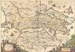
Achaiae Nova & accurata Descriptio. [Karte], in: Novus atlas absolutissimus, Bd. 10, S. 102.
1 Karte aus Atlas Janssonius Offizin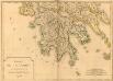
Carte de la Morée anciennement Peloponnèse, 1785
Carte de la Morée anciennement Peloponnèse, 1785. Gravé par L.A. Dupuis ... Lieues communes de France, 20[ = 128 mm] [Paris]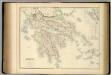
Greece.
1 : 950000 Fullarton, A. & Co.
Peloponesvs sive Morea
1 : 1100000 Peloponés (Řecko) Laurenberg, L.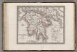
Peloponnese Attique.
1 : 1080000 Monin, C.V.

Regnum Moreae, accuratissime divisum in provincias Saccaniam, Tzaconiam, Caliscopium et ducatum Clarensae, una cum insulis Cephalonia, Zacyntho Cythera, Aegina et Sidra
1 : 580000 sumptibus Tobiae Conradi Lotter Georg Friderich Lotter, sculpsit Aug. Vind : [T.C. Lotter]