Maps of Mecklenburg-Vorpommern
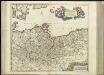
[40][40] Marchionatus Brandenburgi et Ducatus Pomeraniae tabula..., uit: Atlas sive Descriptio terrarum orbis
Annotatie: Gedigitaliseerde versie. Amsterdam. Heiloo : Picturae (vervaardiger), 2015. tiff-bestand. Gedigitaliseerd: 07-01-2015; Origineel: Universiteitsbibliotheek Vrije Universiteit (XL.05127.-) ; Netherlands; Titelpagina ontbreekt Wit, Frederik de Amsterdam : Frederick de Wit
II. 1440 - 1608
Brandenburg Expansion
I. Brandenburg bis zum Tode des 1. Zollernfürsten Friedrich I. 1134 - 1440
Brandenburg Friedrich I., Brandenburg, Kurfürst
Situation des armées Francaises depuis le 10 mars jusqu'á la bataille de Wurtchen (Campagne de 1813)
1 : 2281000
Nord-Östliches Deutschland
Handatlas über alle Theile der Erde und über das Weltgebäude Stieler, Adolf Justus Perthes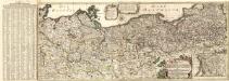
Kriegs Schau-Platz In Preussischen Landen bestehend
1 : 8000000 Mollova mapová sbírka Lidl, Johann Jakob Lidl, Johann Jacob
Nord-Östliches Deutschland
Hand-Atlas über alle Theile der Erde und über das Weltgebäude Stieler, Adolf Justus Perthes
Pomerania XIIII. Nova Tabula. [Karte], in: Claud. Ptolemaeus. Geographia lat. cum mappis [...], S. 392.
1 Karte aus Atlas Münster, Sebastian [und Ptolemaeus, Claudius]

NE pt. of Germany.
1 : 3150000 Bowen, Emanuel
Prussia.
1 : 3400000 Finley, Anthony
Karte der Eisenbahnen Deutschlands
1 : 700000 Nordwest-Blatt Stich, Druck u. Verlag des lithographischen Instituts von Aug. Wehrt
II, uit: General-Karte von Mittel-Europa in 12 Blättern, im Masse 1:1.200.000 / entworfen, bearb. und hrsg. von Josef Schlacher
1 : 1200000 Annotatie: Blad 6 ontbreekt; Annotatie geografische gegevens: 21 maatstokken op blad 9; Legenda op blad 9 Wien : K.K. Militär Geografisches Institut
Marchia sive electoratus Brandenburgicus nec non ducatus Pomeraniae cum magna maris Balthici et provinciarum adnexarum parte
1 : 1028000 Baltské moře Seutter, Matthäus Matthaeus Seutter
Marchionatus Brandenburgensis Ducatus Pomeraniae et Ducatus Macklenburgicus
1 : 870000 Mollova mapová sbírka Seutter, Matthäus Seutter, Matthäus
Leuchtfeuer an den deutschen Küsten
1 : 2000000 Německo Meyer, Joseph Bibliographisches Institut
Kriegs Expeditions Karte von Devtschland
1 : 1700000 Mollova mapová sbírka Rizzi Zannoni, Giovanni Antonio Homann, Johann Baptista - dědici
Marchionatus Brandenburgi et ducatus Pomeraniae tabula quae est pars Septentrionalis circuli Saxoniae Superioris / authore F. de Wit Amstelodami
1 : 1000000 Annotatie: Origineel is Blad 90 in atlas factice; Annotatie geografische gegevens: Met 3 schaalstokken Frederick de Wit 1630-1706 Amstelodami : F. de Wit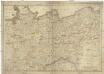
Die Königreiche Sachsen und Westphalen nach der neuesten astronomischen Beobachtungen und den besten Hülfsmitteln verfasst
1 : 1060000 Sasko (Německo) Mollo, Tranquillo T. Mollo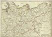
Die Königreiche Sachsen und Westphalen nach der neuesten astronomischen Beobachtungen und den besten Hülfsmitteln verfasst
1 : 1060000 Sasko (Německo) Mollo, Tranquillo T. Mollo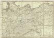
Die Königreiche Sachsen und Westphalen
1 : 1060000 Sasko (Německo) Mollo, Tranquillo T. Mollo

A map of Upper Saxony comprehending that part of Germany which is the present seat of war
1 : 2534400
[Nordöstliches Deutschland]
Schul-Atlas über alle Theile der Erde nach dem neuesten Zustande, und über das Weltgebäude Stieler, Adolf bei Justus Perthes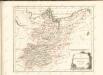

Nord-östliches Deutschland
1 : 1850000 Braniborsko (Německo) Ausfeld, Johann Carl Justus Perthes
[Nord-Östliches Deutschland]
Hand-Atlas über alle Theile der Erde nach dem neuesten Zustande und über das Weltgebäude Stieler, Adolf bei Justus Perthes
Die Königl. Preussischen Provinzen Brandenburg Pommern Sachsen und Schlesien nebst Mecklenburg
Mitteleuropa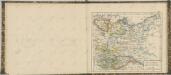

![[40][40] Marchionatus Brandenburgi et Ducatus Pomeraniae tabula..., uit: Atlas sive Descriptio terrarum orbis](https://images-2.georeferencer.com/images/iiif/540618640598/full/,300/0/native.jpg)

