Maps of Spain

[6][6] Accuratissima totius regni Hispaniae tabula, uit: Atlas sive Descriptio terrarum orbis
Annotatie: Gedigitaliseerde versie. Amsterdam. Heiloo : Picturae (vervaardiger), 2015. tiff-bestand. Gedigitaliseerd: 07-01-2015; Origineel: Universiteitsbibliotheek Vrije Universiteit (XL.05127.-) ; Netherlands; Titelpagina ontbreekt Wit, Frederik de Amsterdam : Frederick de Wit
Spain, Portugal.
1 : 4730000 Darton, William
L'Espagne divisée en tous ses royaumes, principautés, &c à l'usage de monseigneur le duc de Bourgogne
1 : 2535000 par [...] H. Iaillot A Amsterdam : chez R. & J. Ottens
Mapa general de España antigua
1 Karte : Kupferdruck ; 33 x 38 cm López se hallarà con todàs las obras del autor y las de su padre
Regnorum Hispaniae nova descriptio. [Karte], in: Le théâtre du monde, ou, Nouvel atlas contenant les chartes et descriptions de tous les païs de la terre, Bd. 2, S. 189.
1 Karte aus Atlas Blaeu, Willem Janszoon und Blaeu, Joan Blaeu, Willem Janszoon
Mapa general de España Antiqua, dividido en tres partes, Bética, Lusitánia y Tarraconénse, con la subdivision de cada una
1 : 3700000 por [...] Juan Lopez, pensionista de S.M [...] Madrid : [Thomas Lopez]

Regnorum Hispaniae nova descriptio. [Karte], in: Novus Atlas, das ist, Weltbeschreibung, Bd. 2, S. 196.
1 Karte aus Atlas Blaeu, Joan Blaeu, Willem Janszoon
Království španělské
Portugalsko tisk a sklad Hynka Fuchse

España: comunicaciones terrestres
Datat al 1950 aproximadament. 0 Seix y Barral
Spanien und Portugal
Allgemeiner Atlas [Walch, Johannes] im Verlag bei Johannes Walch
Carta itineraria de España
1 : 1500000 Depósito Central de Planos de la Dirección General de Obras Públicas
Hispaniae Et Portugalliae Regna [Karte], in: Novus atlas absolutissimus, Bd. 6, S. 18.
1 Karte aus Atlas Janssonius Offizin
Charte von Spanien und Portugal : mit der neuen Eintheilung
1 : 2000000 neu gezeichnet [...] von Christoph Fembo Nürnberg : Fembo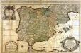
L'Espagne
1 Karte : Kupferdruck ; 53 x 85 cm Sanson; Jaillot chez H. Iaillot joignant les grands Augustins aux deux globes
Regnorum Hispaniae nova descriptio. [Karte], in: Theatrum orbis terrarum, sive, Atlas novus, Bd. 2, S. 192.
1 Karte aus Atlas Blaeu, Joan Blaeu, Willem Janszoon
L'Espagne
1 Karte : Kupferdruck ; 44 x 58 cm Jaillot; Ottens; Ottens chez R. et J. Ottens
L'Espagne
1 Karte : Kupferdruck ; 44 x 58 cm Jaillot s.n.
L'Espagne
1 Karte : Kupferdruck ; 44 x 58 cm Jaillot s.n.
Accuratissima totius regni Hispaniæ et Portugalliæ tabula
1 Karte : Kupferdruck ; 45 x 57 cm Schenk; Sanson s.n.
Regni Hispaniae Post Omnium Editiones Locuplessima Descriptio. [Karte], in: Theatrum orbis terrarum, S. 95.
1 Karte aus Atlas Ortelius, Abraham Vrients, Jan Baptista
Hispaniae Nova Descriptio, De Integro Multis In Locis, Secundum Hydrographicas Desc. Emendata. [Karte], in: Gerardi Mercatoris Atlas, sive, Cosmographicae meditationes de fabrica mundi et fabricati figura, S. 174.
1 Karte aus Atlas Mercator, Gerhard Montanus, Petrus
Regni Hispaniae Post Omnium Editiones Locuplessima Descriptio. [Karte], in: Theatrum orbis terrarum, S. 26.
1 Karte aus Atlas Ortelius, Abraham
L'Espagne
1 Karte : Kupferdruck ; 40 x 52 cm Sanson; Mariette; Cordier chez Pierre Mariette rüe S. Iacques à l'esperance
Die iberische Halbinsel bis in die Mitte des XIIIten Jahrhundert's.
1 : 3800000 Spruner von Merz, Karl
Španiely a Portugaly.

Spanien und Portugal
Hand-Atlas über alle Theile der Erde und über das Weltgebäude Stieler, Adolf Justus Perthes
Spanien und Portugal
Hand-Atlas über alle Theile der Erde nach dem neuesten Zustande und über das Weltgebäude Stieler, Adolf bei Justus Perthes
![[6][6] Accuratissima totius regni Hispaniae tabula, uit: Atlas sive Descriptio terrarum orbis](https://images-0.georeferencer.com/images/iiif/529736186180/full/,300/0/native.jpg)

