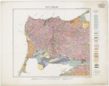
Maps of Kaliningrad

Sect. 6. Königsberg (West-Samland), uit: Geologische Karte der Provinz Preussen
1 : 100000 Annotatie: Incompleet; Voor aanwezige bladen zie bladoverzicht; Met inzetkaarten; Annotatie geografische gegevens: Coördinaten gebaseerd op nulmeridiaan van Ferro (Hierro) Berlin : Neumann
Composite: 28. Cumehnen. (Germany)
1 : 100000 Reichsamt fur Landesaufnahme
28. Cumehnen. (Germany)
1 : 100000 Reichsamt fur Landesaufnahme
Umgegend v. Königsberg
1 : 200000 Königsberg, Umland
Königsberg und Umgegend
1 : 370000 Königsberg, Umland
49. Pillau. (Germany)
1 : 100000 Reichsamt fur Landesaufnahme
Meßtischblatt 1288 : Königsberg (Pr.) (West), 1937
1 : 250000 Königsberg (Pr.) (West). - Hrsg. 1908, bericht. 1922, letzte Nachtr. 1937. - 1:25000. - [Berlin]: Reichsamt für Landesaufnahme, 1937. - 1 Kt.
Meßtischblatt 183 : Königsberg i.Pr., 1930
1 : 250000 Königsberg i.Pr. - Hrsg. 1908, bericht. 1922, einz. Nachtr. 1930. - 1:25000. - [Berlin]: Reichsamt für Landesaufnahme, 1930. - 1 Kt.
Meßtischblatt 1286 : Fischhausen, 1937
1 : 250000 Fischhausen. - Hrsg. 1908, berichtigt 1922, einz. Nachtr. 1937. - 1:25000. - [Berlin]: Reichsamt für Landesaufnahme, 1937. - 1 Kt.
Meßtischblatt1285 : Lochstädt, 1935
1 : 250000 Lochstädt. - Hrsg. 1908, berichtigt 1922. - 1:25000. - [Berlin]: Reichsamt für Landesaufnahme, 1935. - 1 Kt.
Meßtischblatt 1287 : Medenau, 1937
1 : 250000 Medenau. - Hrsg. 1908, bericht. 1922, einz. Nachtr. 1937. - 1:25000. - [Berlin]: Reichsamt für Landesaufnahme, 1937. - 1 Kt.
Meßtischblatt 142 : Rudau, 1928
1 : 250000 Rudau. - Hrsg. 1908, bericht. 1922, einz. Nachtr. 1928. - 1:25000. - [Berlin]: Reichsamt für Landesaufnahme, 1928. - 1 Kt.
Meßtischblatt 1186 : Germau, 1937
1 : 250000 Germau. - Hrsg. 1908, bericht. 1922, einz. Nachtr. 1937. - 1:25000. - [Berlin]: Reichsamt für Landesaufnahme, 1937. - 1 Kt.
Messtischblatt 1185 : Palmnicken, 1937 Palmnicken
1 : 250000 Palmnicken. - Hrsg. 1908, bericht. 1922, einz. Nachtr. 1937. - 1:25000. - [Berlin]: Reichsamt für Landesaufnahme, 1937. - 1 Kt.
Meßtischblatt 141 : Pobethen, 1928
1 : 250000 Pobethen. - Hrsg. 1908, bericht. 1922, einz. Nachtr. 1928. - 1:25000. - [Berlin]: Reichsamt für Landesaufnahme, 1928. - 1 Kt.
Messtischblatt 1088 : Cranz, 1937 Cranz
1 : 250000 Cranz. - Hrsg. 1908, bericht. 1922, einz. Nachtr. 1937. - 1:25000. - [Berlin]: Reichsamt für Landesaufnahme, 1937. - 1 Kt.
Messtischblatt 104 : Rauschen, 1908 Rauschen
1 : 250000 Rauschen. - Aufn. 1906. - 1:25000. - [Berlin]: Reichsamt für Landesaufnahme, 1908. - 1 Kt.
Messtischblatt 1085 : Gr. Dirschkeim, 1937 Gr. Dirschkeim
1 : 250000 Gr. Dirschkeim. - Hrsg. 1908, bericht. 1922, einz. Nachtr. 1937. - 1:25000. - [Berlin]: Reichsamt für Landesaufnahme, 1937. - 1 Kt.
Messtischblatt 1087 : Neukuhren, 1937
1 : 250000 Neukuhren. - Aufn. 1908, bericht. 1922, einz. Nachtr. 1937. - 1:25000. - [Berlin] : Reichsamt für Landesaufnahme. - 1 Kt.
Königsberg i. Pr
1 : 17000 Kaliningrad (Rusko) Bibliographisches Institut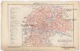
Königsberg
1 : 17600 Kaliningrad (Rusko) F.A. Brockhaus' geogr.-artist. Anstalt
Plan der Königl. Preuss. Haupt- u. Residenzstadt Königsberg
Lith. Anst. v. Adolph Wilutzkij Königsberg : Pfitzer & Heilmann
Koningsberga
[Merian?]
Meßtischblatt 1388 : Ponarth, 1939
1 : 250000 Ponarth. - Aufn. 1906, hrsg. 1908, bericht. 1922, letzte Na. - 1:25000. - [Berlin]: Reichsamt für Landesaufnahme, 1939. - 1 Kt.
Meßtischblatt 1387 : Brandenburg (Frisches Haff), 1937
1 : 250000 Brandenburg (Frisches Haff). - Aufn. 1906, hrsg. 1908, bericht. 1922, letzte Nachtr. 1937. - 1:25000. - [Berlin]: Reichsamt für Landesaufnahme, 1937. - 1 Kt.
Meßtischblatt 1386 : Zimmerbude, 1937
1 : 250000 Zimmerbude. - Aufn. 1906, Hrsg. 1908, bericht. 1922, letzte Nachtr. 1937. - 1:25000. - [Berlin]: Reichsamt für Landesaufnahme, 1937. - 1 Kt.
Meßtischblatt 1385 : Pillau, 1936
1 : 250000 Pillau. - Hrsg. 1908, bericht. 1922. - 1:25000. - [Berlin]: Reichsamt für Landesaufnahme, 1936. - 1 Kt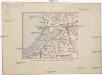
[Kaliningrad a okolí]
1 : 760000 Kaliningrad-oblast (Rusko)
Composite: 49. Pillau. (Germany)
1 : 100000 Reichsamt fur Landesaufnahme