Maps of Kaliningrad

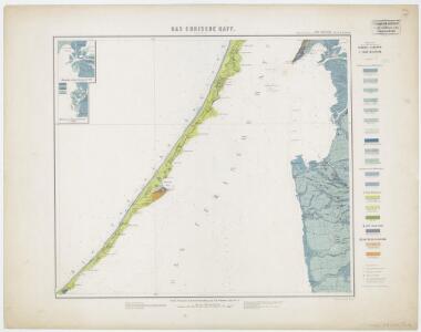
Sect. 3. Rossitten (Das Curische Haff südl. Theil), uit: Geologische Karte der Provinz Preussen
1 : 100000 Annotatie: Incompleet; Voor aanwezige bladen zie bladoverzicht; Met inzetkaarten; Annotatie geografische gegevens: Coördinaten gebaseerd op nulmeridiaan van Ferro (Hierro) Berlin : Neumann
Composite: 16. Rossitten. (Germany)
1 : 100000 Reichsamt fur Landesaufnahme
16. Rossitten. (Germany)
1 : 100000 Reichsamt fur Landesaufnahme
Composite: 15. Sarkau. (Germany)
1 : 100000 Reichsamt fur Landesaufnahme
15. Sarkau. (Germany)
1 : 100000 Reichsamt fur Landesaufnahme
Meßtischblatt 0891 : Rossitten, 1933
1 : 250000 Rossitten. - Aufn. 1910. - 1:25000. - [Berlin]: Reichsamt für Landesaufnahme, 1933. - 1 Kt.
Meßtischblatt 0893 : Kallningken, 1928
1 : 250000 Kallningken. - Hrsg. 1913, einzl. Nachtr. 1928. - 1:25000. - [Berlin]: Reichsamt für Landesaufnahme, 1928. - 1 Kt.
Meßtischblatt 0890 : Kunzen, 1912
1 : 250000 Kunzen. - Aufn. 1910. - 1:25000. - [Berlin]: Reichsamt für Landesaufnahme, 1912. - 1 Kt.
Meßtischblatt 0791, 0792 : Pillkoppen, 1939
1 : 250000 Pillkoppen. - Hrsg. 1911, kl. Nachtr. 1923, redakt. Änd. 1939. - 1:25000. - [Berlin]: Reichsamt für Landesaufnahme, 1939. - 1 Kt.
Meßtischblatt 0793 : Skirwiet, 1938
1 : 250000 Skirwiet. - Hrsg. 1911, einzl. Nachtr. 1927, redakt. Änd. 19. - 1:25000. - [Berlin]: Reichsamt für Landesaufnahme, 1938. - 1 Kt.
Meßtischblatt 0993 : Gilge, 1937
1 : 250000 Gilge. - Hrsg. 1913, einzl. Nachtr. 1937. - 1:25000. - [Berlin]: Reichsamt für Landesaufnahme, 1937. - 1 Kt.
Meßtischblatt 0990 : Mövenhaken, 1935
1 : 250000 Mövenhaken. - Hrsg. 1912. - 1:25000. - [Berlin]: Reichsamt für Landesaufnahme, 1935. - 1 Kt.
Meßtischblatt 0692 : Nidden, 1939
1 : 250000 Nidden. - Hrsg. 1912, red. Änd. 1939. - 1:25000. - [Berlin]: Reichsamt für Landesaufnahme, 1939. - 1 Kt.
Meßtischblatt 0693 : Minge, 1911
1 : 250000 Minge. - Hrsg. 1911. - 1:25000. - [Berlin]: Reichsamt für Landesaufnahme, 1911. - 1 Kt.
5. Rossitten, uit: Topographische Uebersichtskarte des Deutschen Reiches / herausgegeben v. d. Kartogr. Abt. d. Königl. Preuß. Landesaufnahme
1 : 200000 titelvariant: Topogr. Übersichtskarte des Deutschen Reiches; Annotatie: Titel boven bladen ook: Topogr. Übersichtskarte des Deutschen Reiches; Annotatie geografische gegevens: Op elk blad twee maatstokken: 10 Kilometer = 5,5 cm; 1 geogr. Meile = 3,6 cm; Legenda onder op elk blad Königlich Preußische Landesaufnahme. Kartographische Abtheilung [S.l : Königlich Preußische Landesaufnahme, Kartographische Abtheilung]
8. Kinten. (Germany)
1 : 100000 Reichsamt fur Landesaufnahme
Composite: 8. Kinten. (Germany)
1 : 100000 Reichsamt fur Landesaufnahme
Meßtischblatt 0989 : Sarkau, 1938
1 : 250000 Sarkau. - Hrsg. 1912, redakt. Änd. 1938. - 1:25000. - [Berlin]: Reichsamt für Landesaufnahme, 1938. - 1 Kt.
Die Kurische Nehrung und ihre Umgebung
1 : 300000 Russland Litauen Kurische Nehrung Bezzenberger, Adalbert
Tilsit 8, uit: Special-Karte von Mittel-Europa / nach amtlichen Quellen bearbeitet von W. Liebenow
1 : 300000 titelvariant: W. Liebenow's Mittel-Europa; Annotatie: Titel boven de bladen: W. Liebenow's Mittel-Europa Johannes Wilhelm Liebenow 1822-1897 Frankfurt a. M. : Ludwig Ravenstein

30. Labiau. (Germany)
1 : 100000 Reichsamt fur Landesaufnahme
Ostsee
1 : 70000 Baltské moře Reichs-Marine-Amt
Sect. 5: Königsberg, uit: Geologische Karte des Deutschen Reichs in 27 Blaettern / [von] Richard Lepsius ; Red. von C. Vogel
1 : 500000 Annotatie: Blad 18 ontbreekt; Een aantal bladen op linnen; Een aantal bladen gereviseerd 1913-1914; Annotatie geografische gegevens: Met schaalstokken o.a. in kilometers; Legenda Carl Vogel 1828-1897 Gotha : Justus Perthes
Provinz Ostpreussen
1 : 1250000 Ostpreußen
Litauisch und Masurisch
Ostpreußen Litauisch, Masurisch
Prvssia
1 Karte : Kupferdruck ; 35 x 47 cm Mercator; Hondius Henricus Hondius
Ost-Preussen.
1 : 935000 Flemming, Carl