Maps of Switzerland

[Kaart], uit: Carte scolaire du canton de Berne / [éd. par la dir. de l'instruction public du Canton de Berne ; executée par Kümmerly & Frey]
1 : 300000 Annotatie geografische gegevens: Bijkaart op achteromslag: Population et surface des districts du canton de Berne d'après le recensement fédéral de 1930 et la statistique de la superficie de 1923/24 Kümmerly+Frey, Bern Berne : Kümmerly & Frey
Nova Helvetiae Tabula Geographica
1 : 380000 Mollova mapová sbírka Scheuchzer, Johann Jakob Schenk, Peter II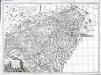
Carte pour l'histoire ancienne de l'Helvétie
1 Karte auf 4 Blatt : Kupferdruck ; 63 x 87 cm Bochat chés Bousquet
L'Helvetia o' Paese de Svizzeri con li Stati
1 : 650000 Mollova mapová sbírka Cantelli, Giacomo De Rossi, Giovanni Giacomo
Eisenbahnkarte der Schweiz
1 : 500000 Topogr. Anstalt v. Wurster, Randegger & Co.
Switzerland
1 : 830000 Švýcarsko Keller, Raymond Walker, J. Society for the Diffusion of Useful Knowledge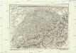
Carte generale de la Suisse suivant ses nouvelles divisions, qui conprennent les ci-devant 13 cantons, leurs alliés et sujets, et forment actuellement la republique Helvetique une et indivisible
1 : 500000 Švýcarsko Mechel, Christian von Chretien de Mechel
Carte générale de la Suisse suivant ses nouvelles divisions, qui comprennent les ci-devant XIII. cantons, leurs alliés et sujets, et forment actuellement la République Helvétique une et indivisible
1 : 510000 Švýcarsko Mechel, Christian von Chretien de Mechel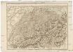
Carte generale de la Suisse suivant ses nouvelles divisions, qui comprennent les ci-devant XIII. cantons, leurs alliés et sujets, et forment actuellement la Republique Helvetique une et indivisible
Švýcarsko Mechel, Christian von Ludvík Chretien de Mechel
Telegraphenkarte der schweizerischen Eisenbahnen
1 : 400000 [s.n.]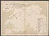
Graphisch-statistischer Atlas der Schweizerischen Normalbahnen
1 : 500000 Historische Entwicklung der Netze 1860 Schweizerische Nordostbahn Lithographie Druck & Verlag von Hofer & Burger
Neüe Charte von Helvetien
1 : 525000 1 Karte Fuessli & Comp., Zürich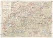
Touristenkarte der Schweiz
1 : 900000 Interlaken (Švýcarsko) Kümmerly & Frey
Helvetia divisa in tredecim cantones
1 Karte : Kupferdruck ; 46 x 58 cm Valck; Valck Gerard und Leonardus Valck
Kaartjen van Zwitzerland
1 : 1370000 1 Karte na Guilaume de l'Isle by I.B. Elwe & D.M. Langeveld, Amsterdam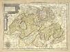
Carte generale des treze cantons de Suisse, Vallay ligues Grise, Maison-Dieu et Valtoline
1 Karte : Kupferdruck ; 35 x 49 cm Tassin s.n.
Karte von der Schweiz
1 : 525000 1 Karte Fuessli & Comp., Zürich
Karte von der Schweiz
1 : 500000 1 Karte Fuessli & Comp., Zürich
Carte genérale de la Suisse, oder, Die Helvetische Republik in XXII Cantone eingetheilt
1 : 525000 1 Karte Joh. Walch bei Joh. Walch, Augsburg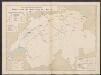
Graphisch-statistischer Atlas der Schweizerischen Normalbahnen
1 : 500000 Historische Entwicklung der Netze 1870 Schweizerische Nordostbahn Lithographie Druck & Verlag von Hofer & Burger
Karte von der Schweiz
1 : 44000 Švýcarsko Reilly, Franz Johann Josef von Faden, William Reilly'schen Landkarten und Kunstwerke Verschleis Komptoir
Karte von der Schweiz
1 : 500000 1 Karte Fuessli & Comp., Zürich
Karte von der Schweiz
1 : 525000 1 Karte Fuessli & Comp., Zürich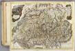
Suisse.
1 : 404000 Faden, William, 1750?-1836
Carte genérale de la Suisse, oder, Die Helvetische Republik in XIX Cantone eingetheilt
1 : 529000 Švýcarsko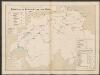
Graphisch-statistischer Atlas der Schweizerischen Normalbahnen
1 : 500000 Historische Entwicklung der Netze 1875 Schweizerische Nordostbahn Lithographie Druck & Verlag von Hofer & Burger
<<Der>> Helvetischen Republik neue Cantons und Districts Eintheilung
1 : 630000 1 Karte dem Vollziehungs-Directorium gewiedmet von Wilhelm Haas dem Sohne im Augstmonat 1798 Haas, Basel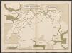
Graphisch-statistischer Atlas der Schweizerischen Normalbahnen
1 : 500000 Leistungen des Betriebsmaterials 1881 Schweizerische Nordostbahn Lithographie Druck & Verlag von Hofer & Burger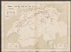
Graphisch-statistischer Atlas der Schweizerischen Normalbahnen
1 : 500000 Historische Entwicklung der Netze 1855 - 1882 Schweizerische Nordostbahn Lithographie Druck & Verlag von Hofer & Burger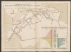
![[Kaart], uit: Carte scolaire du canton de Berne / [éd. par la dir. de l'instruction public du Canton de Berne ; executée par Kümmerly & Frey]](https://images-2.georeferencer.com/images/iiif/089671803289/full/,300/0/native.jpg)

