Maps of Kreis Düren

Bl. 36 Herzogenrath, 1904, uit: Atlas A.N.W.B.
1 : 200000 titelvariant: Atlas van Nederland van den A.N.W.B. Toeristenbond voor Nederland; Wielrijders-atlas van Nederland; Annotatie: Titel op bladwijzer: Atlas van Nederland van den A.N.W.B. Toeristenbond voor Nederland; Titel op legendablad: Wielrijders-atlas van Nederland; Voor aanwezige bladen zie overzichtsblad; Annotatie geografische gegevens: De serie bestaat uit 36 bladen ANWB ['s-Gravenhage : A.N.W.B.]
Geologische Exkursionskarte für die Umgegend von Aachen / [W. Wunstorf]
1 : 75000 Annotatie: Omslagtitel; Met profielen W. Wunstorf Berlin : [s.n.] / (Berlin : Kraatz)
Meßtischblatt 5104 : Düren, 1940
1 : 250000 Düren. - Aufn. 1893, hrsg. 1895, bericht. 1938, Ausg. 1940, Nur für d. Dienstgebrauch!. - 1:25000. - [Berlin]: Reichsamt für Landesaufnahme, 1940. - 1 Kt.
Meßtischblatt 5103 : Eschweiler, 1942
1 : 250000 Eschweiler. - Aufn. 1893, hrsg. 1895, bericht. 1937, letzte Nachtr. 1940, Ausg. 1942, vorläuf. Ausg.. - 1:25000. - [Berlin]: Reichsamt für Landesaufnahme, 1942. - 1 Kt.
Meßtischblatt 2904 : Jülich, 1934
1 : 250000 Jülich. - Hrsg. 1894, bericht. 1934. - 1:25000. - [Berlin]: Reichsamt für Landesaufnahme, 1934. - 1 Kt.
Meßtischblatt 2904 : Jülich, 1926
1 : 250000 Jülich. - Aufn. 1893, bericht. 1909, Nachtr. 1926. - 1:25000. - [Berlin]: Reichsamt für Landesaufnahme, 1926. - 1 Kt.
Meßtischblatt 2904 : Jülich, 1894
1 : 250000 Jülich. - Aufn. 1893, hrsg. 1894. - 1:25000. - [Berlin]: Reichsamt für Landesaufnahme, 1894. - 1 Kt.
Meßtischblatt 2904 : Linnich, 1895
1 : 250000 Linnich. - Aufn. 1893. - 1:25000. - [Berlin]: Reichsamt für Landesaufnahme, 1895. - 1 Kt.
Meßtischblatt 2840 : Titz, 1895
1 : 250000 Titz. - Aufn. 1893. - 1:25000. - [Berlin]: Reichsamt für Landesaufnahme, 1895. - 1 Kt.
Meßtischblatt 2839 : Erkelenz, 1895
1 : 250000 Erkelenz. - Aufn. 1893. - 1:25000. - [Berlin]: Reichsamt für Landesaufnahme, 1895. - 1 Kt.
76 Herzogenrath, uit: De Tranchotkaart van het gebied tussen Maas en Rijn : Nederlands gedeelte
Annotatie: Omslagtitel; Facs. van het Nederlandse deel van de manuscriptkaart van het Rijnland vervaardigd o.l.v. Jean Joseph Tranchot, 1803-1820. - Gereduceerd van 1:20.000 tot 1:25.000 Jean Joseph Tranchot 1752-1815 [Maastricht : Stichting Maaslandse Monografieën]
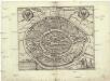
IVLIACI OBSIDIO Ao. MDCXI.
[Amsterdam : Joan Blaeu]
29th Division. March through Belgium and Germany across the Rhine to Bridghead. Sheet 2
1 : 250000 29th Division. March through Belgium and Germany across the Rhine to Bridghead. Sheet 2. Shows route of 29th Division who marched from Renaix in Belgium to Cologne in Germany to secure Rhine bridgehead immediately following the end of the First World War. War Office
Meßtischblatt 2969 : Buir, 1895
1 : 250000 Buir. - Aufn. 1893. - 1:25000. - [Berlin]: Reichsamt für Landesaufnahme, 1895. - 1 Kt.
Meßtischblatt 5005 : Bergheim, 1940
1 : 250000 Bergheim. - Aufn. 1893, hrsg. 1895, bericht. 1938, Ausg. 1940. - 1:25000. - [Berlin]: Reichsamt für Landesaufnahme, 1940. - 1 Kt.
Meßtischblatt 2841 : Grevenbroich, 1895
1 : 250000 Grevenbroich. - Aufn. 1893. - 1:25000. - [Berlin]: Reichsamt für Landesaufnahme, 1895. - 1 Kt.
Iülich.
Mollova mapová sbírka Bodenehr, Gabriel Bodenehr, Gabriel
Wahrer Grundtriss der Statt und Vestung Gülich
Mollova mapová sbírka Merian, Matthaeus Merian, Matthäus
GVLICH : [fortification plan]
[Amsterdam : Joan Blaeu]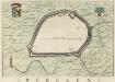
ERCKELENS
[Amsterdam : Joan Blaeu]
Meßtischblatt 5204 : Lendersdorf, 1941
1 : 250000 Lendersdorf. - Aufn. 1893, hrsg. 1895, bericht. 1938, Ausg. 1941. - 1:25000. - [Berlin]: Reichsamt für Landesaufnahme, 1941. - 1 Kt.
Meßtischblatt 3030 : Stolberg, 1907
1 : 250000 Stolberg. - Aufn. 1893, hrsg. 1895, einz. Nachtr. 1907. - 1:25000. - [Berlin]: Kgl. Preuss. Landesaufnahme, 1907. - 1 Kt.
Meßtischblatt 3030 : Stolberg, 1895
1 : 250000 Stolberg. - Aufn. 1893. - 1:25000. - [Berlin]: Kgl. Preuss. Landesaufnahme, 1895. - 1 Kt.
Meßtischblatt 3032 : Vettweiss, 1894
1 : 250000 Vettweiss. - Aufn. 1893. - 1:25000. - [Berlin]: Kgl. Preuss. Landesaufnahme, 1894. - 1 Kt.
56 Heinsberg, uit: De Tranchotkaart van het gebied tussen Maas en Rijn : Nederlands gedeelte
Annotatie: Omslagtitel; Facs. van het Nederlandse deel van de manuscriptkaart van het Rijnland vervaardigd o.l.v. Jean Joseph Tranchot, 1803-1820. - Gereduceerd van 1:20.000 tot 1:25.000 Jean Joseph Tranchot 1752-1815 [Maastricht : Stichting Maaslandse Monografieën]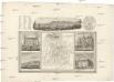
Aachen
Cáchy (Německo) Schedler, J. Meysel, Alfred
Aachen
Grosser Hand-Atlas über alle Theile der Erde in 170 Karten Meyer, J. Verlag des Bibliographischen Instituts
Carte des environs d'Aix-la-Chapelle
1 : 40000 lith. de La Ruelle & Destez Aix-la-Chapelle : La Ruelle & Destez
AQVISGRANVM. | Gallis | AIX LA CHAPELLE. | Germanis et Belgis | AKEN
[Amsterdam : Joan Blaeu]