Maps of Epe

Kaart ten behoeve der cavaleriemanoeuvres in 1892 op de schaal van 1:50.000 / [Topographische Inrichting]
1 : 50000 Annotatie geografische gegevens: Gedeeltelijke compilatie van: Chromo-topographische kaart van het Koninkrijk der Nederlanden ..., bl. 27, 32, 33; De kaart geeft het gebied tussen Nijkerk, Apeldoorn en Hattem weer Topographische Inrichting ['s-Gravenhage : Topographische Inrichting]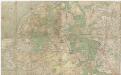
Manoeuvreerkaart der [4de Divisie] Infanterie [in 1907] op de schaal van 1:50.000 / [Topographische Inrichting]
1 : 50000 Annotatie: De titel van de kaart is gedeeltelijk onleesbaar Topographische Inrichting ['s-Gravenhage : Topographische Inrichting]
3de blad, uit: Topographische kaart van de provincie Gelderland / vervaardigd door W. Kuyk Jzn. ; op steen gegrav. door A. Bayly en J.M. Huart ; gelithogr. door J.M. Huart
1 : 50000 titelvariant: Kaart der provincie Gelderland; Annotatie: Omslagtitel: Kaart der provincie Gelderland; Vervaardigd in opdracht van de Staten van Gelderland; Met register van trigonometrische punten (bl. 4) en bladwijzer (bl. 5) W. Kuyk Jzn fl. 1843; Bayly, A.; Huart, J. M. [S.l. : s.n.]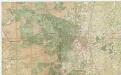
Chromo-topographische kaart van Apeldoorn en omgeving op de schaal van 1:25.000 / bew. door de Militaire Verkenningen
1 : 25000 Annotatie geografische gegevens: Compilatie van: Chromo-topographische kaart van het Koninkrijk der Nederlanden ..., bl. 411-412 Dienst der Militaire Verkenningen ['s-Gravenhage : Topographische Inrichting]
Kaart van het Loo en van deszelfs omstreken : naar de plans van het kadaster bewerkt
1 : 20000 Lith.e. van H.J. van Leeuwen te 's-Gravenhage. [S.l.] : [s.n.]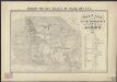
Kaart van het paleis en park het Loo : naar 't origineel plan van het Loo bewerkt
1 : 5000 Lith.e. van H.J. van Leeuwen te 's-Gravenhage. [S.l.] : [s.n.]
[Top] ELBVRG : [view]; [bottom] [Fortification plan of Elburg].
[Amsterdam : Joan Blaeu]
HARDERWIICK.
[Amsterdam : Joan Blaeu]
Ducatus Geldriae Tetrarchia Arnhemiensis Sive Velavia
1 : 180000 Mollova mapová sbírka Wit, Frederik de Covens, Johannes I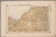
15. Veluwe, uit: Geologische kaart van Nederland : schaal van 1:200.000 / door W.C.H. Staring ; uitgevoerd door het Topographisch Bureau van Oorlog ; uitgegeven op last van Zijne Majesteit Den Koning
Annotatie: Impressum ontleend aan omslag; Kaart "Nederland de dijken weggedacht" [kaart 25] en kaart 13 (bladwijzer) vermelden het jaar 1869; Kaart 'Limburg en de Hesbaije' (bladnr. 26) vermeldt het jaar 1868; Blad 5/9 ontbreekt Topographische Inrichting, 's-Gravenhage; Topographisch Bureau Haarlem : A.C. Kruseman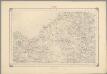
10, uit: Topografische atlas van het Koninkrijk der Nederlanden
Annotatie: Map met 19 losse krt. schaal 1:200.000 en 1 bladwijzer schaal 1:1.000.000 ['s-Gravenhage : Ministerie van Oorlog, Topografisch Bureau]
TETRARCHIA | Ducatus Gelriæ | ARNHEMIENSIS, | sive | VELAVIA
[Amsterdam : Joan Blaeu]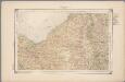
15. Veluwe, uit: Geologische kaart van Nederland / door W.C.H. Staring ; bew. aan de Topographische Inrichting
1 : 200000 Winand Carel Hugo Staring 1808-1877; Topographische Inrichting, 's-Gravenhage 's-Gravenhage : Belinfante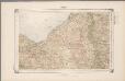
15. Veluwe, uit: Geologische kaart van Nederland / door W.C.H. Staring ; bew. aan de Topographische Inrichting
1 : 200000 Winand Carel Hugo Staring 1808-1877; Topographische Inrichting, 's-Gravenhage 's-Gravenhage : Belinfante
Ducatus Geldriae tetrachia Arnhemiensis sive Velavia.
1 : 130000 Amstelodami : apud Covens et Mortier
Nieuwe kaart van 't Kwartier De Veluwe
1 : 250000 J. Keizer fecit 1741. Te Amsterdam : by Isaak Tirion
15me Zutphen, uit: [Nouvelle carte de la Hollande, d'après Kraijenhoff et les meilleures cartes connus] / [Ph. Vandermaelen]
1 : 130000 Annotatie: Ontbreekt: bl. 1-12 Vandermaelen, Philippe Marie Guillaume Bruxelles : Établissement Géographique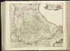
[96][97] Ducatus Geldriae Tetrachia Arnhemiensis sive Velavia, uit: Atlas sive Descriptio terrarum orbis
Annotatie: Gedigitaliseerde versie. Amsterdam. Heiloo : Picturae (vervaardiger), 2015. tiff-bestand. Gedigitaliseerd: 07-01-2015; Origineel: Universiteitsbibliotheek Vrije Universiteit (XL.05127.-) ; Netherlands; Titelpagina ontbreekt Wit, Frederik de Amsterdam : Frederick de Wit
15me Zutphen, uit: Nouvelle carte de la Hollande, d'après Kraijenhoff et les meilleures cartes connues / Établissement Géographique de Bruxelles, fondé par Ph. Vander Maelen
1 : 117000 Annotatie: De bladen zijn genummerd 1-24. De bladen 2 t/m 24 hebben elk een afzonderlijke titel. Blad 5 bevat: Triangulations et positions. Blad 9 bevat: Plan d'Amsterdam; De kaartbladen 1, 5, 9 en 24 zijn niet ingekleurd; Van kaartblad 24 is een extra (ingekleurd) exempl. aanwezig; Annotatie geografische gegevens: 2 schaalstokken: 5 Echelle de 5 lieues de 20 au degré ... (= 23,2 cm) en 7380 Echelle de 5 lieues de 20 au degré ... (= 23,2 cm); Legenda; Met indexkaart: Carte d'assemblage Philippe Marie Guillaume Vander Maelen 1795-1869; Établissement Géographique de Bruxelles Bruxelles : Établissement Géographique
Partie du Duche de Gueldre où se trouve la Veluwe
1 : 300000 [Guillaume Delahaye] [Paris] : par le sr. Robert geog. du roi
Bl. 19 Arnhem, 1904, uit: Atlas A.N.W.B.
1 : 200000 titelvariant: Atlas van Nederland van den A.N.W.B. Toeristenbond voor Nederland; Wielrijders-atlas van Nederland; Annotatie: Titel op bladwijzer: Atlas van Nederland van den A.N.W.B. Toeristenbond voor Nederland; Titel op legendablad: Wielrijders-atlas van Nederland; Voor aanwezige bladen zie overzichtsblad; Annotatie geografische gegevens: De serie bestaat uit 36 bladen ANWB ['s-Gravenhage : A.N.W.B.]
Bl. 19 Arnhem, 1918, uit: Atlas A.N.W.B.
1 : 200000 titelvariant: Atlas van Nederland van den A.N.W.B. Toeristenbond voor Nederland; Wielrijders-atlas van Nederland; Annotatie: Titel op bladwijzer: Atlas van Nederland van den A.N.W.B. Toeristenbond voor Nederland; Titel op legendablad: Wielrijders-atlas van Nederland; Voor aanwezige bladen zie overzichtsblad; Annotatie geografische gegevens: De serie bestaat uit 36 bladen ANWB ['s-Gravenhage : A.N.W.B.]
Bl. 19 Arnhem, 1907, uit: Atlas A.N.W.B.
1 : 200000 titelvariant: Atlas van Nederland van den A.N.W.B. Toeristenbond voor Nederland; Wielrijders-atlas van Nederland; Annotatie: Titel op bladwijzer: Atlas van Nederland van den A.N.W.B. Toeristenbond voor Nederland; Titel op legendablad: Wielrijders-atlas van Nederland; Voor aanwezige bladen zie overzichtsblad; Annotatie geografische gegevens: De serie bestaat uit 36 bladen ANWB ['s-Gravenhage : A.N.W.B.]
Bl. 19 Arnhem, 1921, uit: Atlas A.N.W.B.
1 : 200000 titelvariant: Atlas van Nederland van den A.N.W.B. Toeristenbond voor Nederland; Wielrijders-atlas van Nederland; Annotatie: Titel op bladwijzer: Atlas van Nederland van den A.N.W.B. Toeristenbond voor Nederland; Titel op legendablad: Wielrijders-atlas van Nederland; Voor aanwezige bladen zie overzichtsblad; Annotatie geografische gegevens: De serie bestaat uit 36 bladen ANWB ['s-Gravenhage : A.N.W.B.]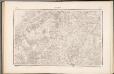
27 Hattem, uit: Topographische en militaire kaart van het Koningrijk der Nederlanden / vervaardigd door de officieren van den Generale Staf ; en gegraveerd op het Topographisch Bureau, van het Ministerie van Oorlog
1 : 50000 titelvariant: TMK; Annotatie: Met bladwijzer op schaal 1:600.000. - 1915; Met Verklaring van de topographische en militaire kaart van het Koninkrijk der Nederlanden. - 1910; Bd. 1: titelblad, bladwijzer, verklaring, bladen 1 t/m 32; Bd. 2: bladen 33 t/m 62 Generale Staf, Nederland; Ministerie van Oorlog. Topographisch Bureau ['s-Gravenhage : Ministerie van Oorlog]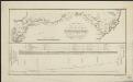
Kaartje van de rivier den IJssel, waarop aangewezen zijn, de nieuw te graven mond met de vereischte afsnijdingen en verbreedingen, welke dezelve zal moeten ondergaan, ten einde, bij eventuele afsluiting van de rivier de Leck al het water en ijs te kunnen ontvangen ...
1 : 200000 gegraveerd door C. van Baarsel en Zoon. [S.l] : [s.n.]
26 Harderwijk, uit: Topographische en militaire kaart van het Koningrijk der Nederlanden / vervaardigd door de officieren van den Generale Staf ; en gegraveerd op het Topographisch Bureau, van het Ministerie van Oorlog
1 : 50000 titelvariant: TMK; Annotatie: Met bladwijzer op schaal 1:600.000. - 1915; Met Verklaring van de topographische en militaire kaart van het Koninkrijk der Nederlanden. - 1910; Bd. 1: titelblad, bladwijzer, verklaring, bladen 1 t/m 32; Bd. 2: bladen 33 t/m 62 Generale Staf, Nederland; Ministerie van Oorlog. Topographisch Bureau ['s-Gravenhage : Ministerie van Oorlog]
Bl. 13 Zwolle, 1904, uit: Atlas A.N.W.B.
1 : 200000 titelvariant: Atlas van Nederland van den A.N.W.B. Toeristenbond voor Nederland; Wielrijders-atlas van Nederland; Annotatie: Titel op bladwijzer: Atlas van Nederland van den A.N.W.B. Toeristenbond voor Nederland; Titel op legendablad: Wielrijders-atlas van Nederland; Voor aanwezige bladen zie overzichtsblad; Annotatie geografische gegevens: De serie bestaat uit 36 bladen ANWB ['s-Gravenhage : A.N.W.B.]
8ste blad, uit: Topographische kaart van de provincie Gelderland / vervaardigd door W. Kuyk Jzn. ; op steen gegrav. door A. Bayly en J.M. Huart ; gelithogr. door J.M. Huart
1 : 50000 titelvariant: Kaart der provincie Gelderland; Annotatie: Omslagtitel: Kaart der provincie Gelderland; Vervaardigd in opdracht van de Staten van Gelderland; Met register van trigonometrische punten (bl. 4) en bladwijzer (bl. 5) W. Kuyk Jzn fl. 1843; Bayly, A.; Huart, J. M. [S.l. : s.n.]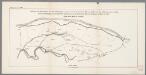
![Kaart ten behoeve der cavaleriemanoeuvres in 1892 op de schaal van 1:50.000 / [Topographische Inrichting]](https://images-2.georeferencer.com/images/iiif/728484685476/full/,300/0/native.jpg)

