Maps of Landkreis Ostallgäu

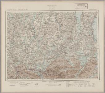
188. Kaufbeuren, uit: Topographische Uebersichtskarte des Deutschen Reiches / herausgegeben v. d. Kartogr. Abt. d. Königl. Preuß. Landesaufnahme
1 : 200000 titelvariant: Topogr. Übersichtskarte des Deutschen Reiches; Annotatie: Titel boven bladen ook: Topogr. Übersichtskarte des Deutschen Reiches; Annotatie geografische gegevens: Op elk blad twee maatstokken: 10 Kilometer = 5,5 cm; 1 geogr. Meile = 3,6 cm; Legenda onder op elk blad Königlich Preußische Landesaufnahme. Kartographische Abtheilung [S.l : Königlich Preußische Landesaufnahme, Kartographische Abtheilung]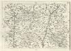
Geographica Provinciarum Sveviae Descriptio =
Mollova mapová sbírka Hurter, Johann Christoph Bodenehr, Johann Georg
Ober Ammergau.
from Spezialkarte der osterreichisch-ungarischen Monarchie.
Fussen (Bayern).
from Spezialkarte der osterreichisch-ungarischen Monarchie.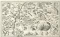
Fuessen, Raitenbuch, Ethal a okolí]
Mollova mapová sbírka Bodenehr, Gabriel Bodenehr, Gabriel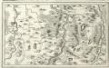
Kavfbeiren, Löder, Schonga, Weilheim a okolí]
Mollova mapová sbírka Bodenehr, Gabriel Bodenehr, Gabriel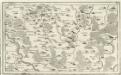
Ottenbeüren, Güntzberg, Ursin oder Yrsee a okolí]
Mollova mapová sbírka Bodenehr, Gabriel Bodenehr, Gabriel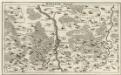
Kempter Gegend
Mollova mapová sbírka Bodenehr, Gabriel Bodenehr, Gabriel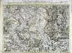
Carte topographique d'Allemagne contenant une partie de Baviére de Suabe du comté de Tirol et de l'eveché d'Augspourg
1 Karte : Kupferdruck ; 45 x 64 cm Jaeger; Facius se vend chez l'auteur
Militair Karte von Süd-Deutschland in 20 Sectionen
1 : 400000 14. Section Coulon, Alois von A. von Coulon
Pars VII. describit partem regim: monach: intra Lycum et Isaram versus merid: sitam secund: ej[us] præf: partic. episc: Augustani, comit: Werdenfels et Tirol
1 Karte : 54 x 52 cm Heinrich Ludwig Broenner
Suevia universa IX. tabulis delineata, 6
1 Blatt : s.n.
Describit Partem Regim: Monach: intra Lycum et Isaram versus Merid: sitam Secund: ej; Præf: Partic. Episc: Augustani, Comit: Werdenfels et Tirol
1 : 150000 Mollova mapová sbírka Buna, Wilhelm C. Broenner, Heinrich Ludwig
Suevia universa IX. tabulis delineata, 9
1 Blatt : s.n.
Wandkarte der Schweiz
1 : 200000 1 Karte auf 8 Blättern J.M. Ziegler Wurster, Winterthur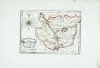
Die gefürstete Abtey Kempten
1 Karte : Kupferdruck ; 19 x 27 cm Reilly F. J. J. von Reilly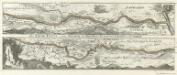
Der Lech-Fluss von Füessen im Algöw an Bis zu seinen Auslauff in die Donaw.
1 : 180000 Mollova mapová sbírka Bodenehr, Gabriel Bodenehr, Gabriel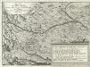
Grundriß des Ihler Flusses
Mollova mapová sbírka Esser, Johann Georg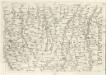
Geographica Provinciarum Sveviae Descriptio =
Mollova mapová sbírka Hurter, Johann Christoph Bodenehr, Johann Georg
Suevia Universa :
1 : 170000 Mollova mapová sbírka Michal, Jacques de Seutter, Matthäus Seutter, Matthäus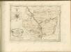
Die gefürstete Abtey Kempten mit der freyen Reichsstadt Kempten : Nro. 183
Reilly, Franz Johann Joseph von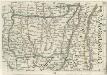
Geographica Provinciarum Sveviae Descriptio =
Mollova mapová sbírka Hurter, Johann Christoph Bodenehr, Gabriel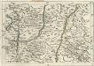
Geographica Provinciarum Sveviae Descriptio =
Mollova mapová sbírka Hurter, Johann Christoph Bodenehr, Gabriel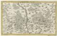
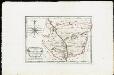
Kempter Gegend.
1 : 140000 Mollova mapová sbírka Bodenehr, Gabriel Bodenehr, Gabriel
Bairische Landtafeln XXIIII. Darinnē das hochlöblich Furstenthumb Obern unnd Nidern Bayrn sambt der Obern Pflaz Erz unnd Stifft Salzburg Eichstet unnd andern mehrern anstossenden Herschafftē]
1 : 145000 Mollova mapová sbírka Apian, Philipp Amman, Jost Apian, Petrus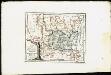
Lande der Grafen Fugger mit den Herrschaften Thannhausen, Schwabeck und Mindelheim, den Benachbarten Abteyen und der freyen Reichsstadt Kaufbeuren
Reilly, Franz Johann Joseph von
Reutte - Partenkirchen - Wetterstein - Gebirge
Murnaw, BenedictBeüren, Kochel See, Walchen See a okolí]
Mollova mapová sbírka Bodenehr, Gabriel Bodenehr, Gabriel