Maps of Landkreis Cham

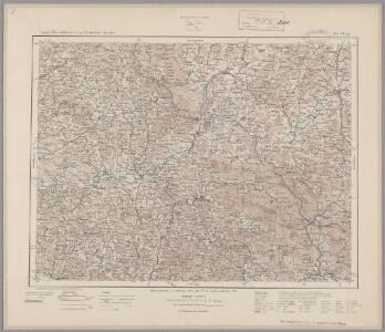
165. Cham, uit: Topographische Uebersichtskarte des Deutschen Reiches / herausgegeben v. d. Kartogr. Abt. d. Königl. Preuß. Landesaufnahme
1 : 200000 titelvariant: Topogr. Übersichtskarte des Deutschen Reiches; Annotatie: Titel boven bladen ook: Topogr. Übersichtskarte des Deutschen Reiches; Annotatie geografische gegevens: Op elk blad twee maatstokken: 10 Kilometer = 5,5 cm; 1 geogr. Meile = 3,6 cm; Legenda onder op elk blad Königlich Preußische Landesaufnahme. Kartographische Abtheilung [S.l : Königlich Preußische Landesaufnahme, Kartographische Abtheilung]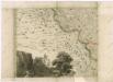
Müllerova mapa Čech
1 : 132000
Bairische Landtafeln XXIIII. Darinnē das hochlöblich Furstenthumb Obern unnd Nidern Bayrn sambt der Obern Pflaz Erz unnd Stifft Salzburg Eichstet unnd andern mehrern anstossenden Herschafftē]
1 : 145000 Mollova mapová sbírka Apian, Philipp Amman, Jost Apian, Petrus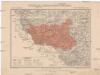
Generální mapa okresního hejtmanství Domažlického
1 : 220000 Domažlice-oblast (Česko) Wagner, Jan Eduard F. Kytka
Podrobná mapa Království českého
1 : 100000 Furth im Wald (Německo) Srp, Jan Jaroslav Bursík
Klentsch.
from Spezialkarte der osterreichisch-ungarischen Monarchie.
Taus und Klattau.
from Spezialkarte der osterreichisch-ungarischen Monarchie.
Podrobná mapa království Českého: Brod n. L.-Sv. Kateřina

Hospodářská mapa revíru Podzámčí
1 : 5835
Taus und Klattau
1 : 75000 Domažlice (Česko : oblast) K. u. k. Militärgeographisches Institut
Železná Ruda a Viechtach
1 : 75000 Německo Vojenský zeměpisný ústav
III. vojenské mapování 4249
1 : 75000
Das Tauser Grenzgebiet
1 : 200000 Chodsko (Česko)
Eisenstein und Viechtach.
from Spezialkarte der osterreichisch-ungarischen Monarchie.
II. vojenské mapování 23
1 : 144000
Eisenstein und Viechtach
1 : 75000 Železná Ruda (Česko : oblast) Brunner K. u. k. militär-geographisches Institut
Eisenstein und Viechtach
1 : 75000 Železná Ruda (Česko : oblast) K. u. k. Militärgeographisches Institut
Klatovy
1 : 75000 Klatovy-oblast (Česko) Vojenský zeměpisný ústav
Klatovy
1 : 75000 Klatovy (Česko : oblast) Vojenský zeměpisný ústav
III. vojenské mapování 4350
1 : 75000
Kleneč p. Čerchovem
1 : 75000 Klenčí pod Čerchovem-oblast (Česko) Vojenský zeměpisný ústav
Klentsch
1 : 75000 Klenčí pod Čerchovem (Česko : oblast) K. u. k. Militärgeographisches Institut

III. vojenské mapování 4250
1 : 75000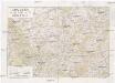
Chodsko
1 : 100000 Chodsko (Česko) Klub českých turistů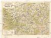
Chodsko
1 : 100000 Chodsko (Česko) Klub českých turistů

Hraniční mapa-zemská hranice mezi Folmavou a Fleky
1 : 12753