Maps of powiat wieluński

121. Landsberg i. O. Sch., uit: Topographische Uebersichtskarte des Deutschen Reiches / herausgegeben v. d. Kartogr. Abt. d. Königl. Preuß. Landesaufnahme
1 : 200000 titelvariant: Topogr. Übersichtskarte des Deutschen Reiches; Annotatie: Titel boven bladen ook: Topogr. Übersichtskarte des Deutschen Reiches; Annotatie geografische gegevens: Op elk blad twee maatstokken: 10 Kilometer = 5,5 cm; 1 geogr. Meile = 3,6 cm; Legenda onder op elk blad Königlich Preußische Landesaufnahme. Kartographische Abtheilung [S.l : Königlich Preußische Landesaufnahme, Kartographische Abtheilung]
Dsjaloschin
1 : 75000 K. u. k. Militärgeographisches Institut
Meßtischblatt 2901 : Gollor- Mühle, 1926
1 : 250000 Gollor- Mühle. - Aufn. 1884, einz. Nachtr. 1926. - 1:25000. - [Berlin]: Reichsamt für Landesaufnahme, 1926. - 1 Kt.
Meßtischblatt 4976 : Landsberg OS, 1940
1 : 250000 Landsberg OS. - Aufn. 1884, hrsg. 1886, bericht. 1939, letzte Na. - 1:25000. - [Berlin]: Reichsamt für Landesaufnahme, 1940. - 1 Kt.
Meßtischblatt 4876 : Wittenau, 1940
1 : 250000 Wittenau. - Aufn. 1884, hrsg. 1886, bericht. 1939, letzte Nachtr. 1932. - 1:25000. - [Berlin]: Reichsamt für Landesaufnahme, 1940. - 1 Kt.
Wielun 78, uit: Special-Karte von Mittel-Europa / nach amtlichen Quellen bearbeitet von W. Liebenow
1 : 300000 titelvariant: W. Liebenow's Mittel-Europa; Annotatie: Titel boven de bladen: W. Liebenow's Mittel-Europa Johannes Wilhelm Liebenow 1822-1897 Frankfurt a. M. : Ludwig Ravenstein
Kolonie założone za panowania Fryderyka Wielkiego na Śląsku pruskim
Polen Schlesien Preußen Stadtgründung Friedrich II.
Sect. 21: Breslau, uit: Geologische Karte des Deutschen Reichs in 27 Blaettern / [von] Richard Lepsius ; Red. von C. Vogel
1 : 500000 Annotatie: Blad 18 ontbreekt; Een aantal bladen op linnen; Een aantal bladen gereviseerd 1913-1914; Annotatie geografische gegevens: Met schaalstokken o.a. in kilometers; Legenda Carl Vogel 1828-1897 Gotha : Justus Perthes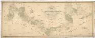
Situations Plan der trokenen Landesgraenze zwischen dem Weichsel und Pietruvka Flus von kais. koen. Oesterreich. Schlesien und koen. Preussisch Schlesien
1 : 10000 Visla-oblast (Polsko) Kuffay, Franz Engel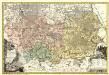
Principatvs Silesiae Rattiboriensis nova et exactissima Tabula geographica commonstrans insimul Liberas Dynastias Ples et Bevthen, cum Statu minore Loslav.
1 : 108000 Mollova mapová sbírka Wieland, Johann Wolfgang Homann, Johann Baptista - dědici
Kartographische Darstellung der Abstimmungs-Ergebnisse von Oberschlesien
1 : 100000 [im Auftrag des Auswärtigen Amtes bearb. in der Plankammer des Preußisch-Statistischen Landesamtes vom Gerke] ; mit Genehmigung der Landesaufnahme, Berlin Berlin : Berliner Lithographisches Institut
Granica Polski na Śląsku górnym
1 : 600000 Polsko Instytut kartograficzny Atlas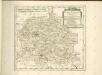

Breslau 77, uit: Special-Karte von Mittel-Europa / nach amtlichen Quellen bearbeitet von W. Liebenow
1 : 300000 titelvariant: W. Liebenow's Mittel-Europa; Annotatie: Titel boven de bladen: W. Liebenow's Mittel-Europa Johannes Wilhelm Liebenow 1822-1897 Frankfurt a. M. : Ludwig Ravenstein
Bez titulu: Přehledná mapa střední Evropy

Militair- Commerzial- und Post-Strassen von Dresden nach Warschau
Drážďany (Německo)
Militair- Commerzial- und Post-Strassen von Dresden nach Warschau
Drážďany (Německo)
Strategische Übersichts-Karte des polnisch-litaurischen Armee-Bewegungraumes
Galizien, Karpathen, Bukowina nebst anschließendem Ungarn, Russland u. s. w.
Ravenstein, Hans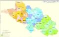
Kreise der Provinz Schlesien 1864
Preußen, Schlesien, Verwaltungsgliederung Kunz, Andreas ; Moeschl, Joachim Robert
Silesia.
1 : 1700000 Bowen, Frances
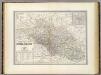
Preussische Provinz Schlessien
1 : 600000 Prusko Gräf, Adolf Geographisches Institut
Preussische Provinz Schlessien
1 : 550000 Slezsko (Polsko) Gräf, Adolf Biedermann, E. Geographisches Institut
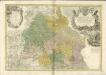
Provinz Schlesien

Ducatus Silesiae Tabula
1 : 1430000 Mollova mapová sbírka Pfeffel, Johann Andreas Engelbrecht, Christian
Ducatus Silesiae Tabula.
1 : 1430000 Mollova mapová sbírka Pfeffel, Johann Andreas Engelbrecht, Christian
Ducatus Silesiae tabula Accuratissima
1 : 1450000 Mollova mapová sbírka Pfeffel, Johann Andreas
Die Preussische Provinz Posen, bestehend aus den Regierungs-Bezirken: Posen & Bromberg
1 : 1850000 Provinz Posen