Maps of Landkreis Northeim

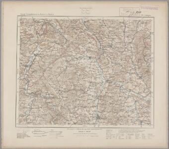
99. Göttingen, uit: Topographische Uebersichtskarte des Deutschen Reiches / herausgegeben v. d. Kartogr. Abt. d. Königl. Preuß. Landesaufnahme
1 : 200000 titelvariant: Topogr. Übersichtskarte des Deutschen Reiches; Annotatie: Titel boven bladen ook: Topogr. Übersichtskarte des Deutschen Reiches; Annotatie geografische gegevens: Op elk blad twee maatstokken: 10 Kilometer = 5,5 cm; 1 geogr. Meile = 3,6 cm; Legenda onder op elk blad Königlich Preußische Landesaufnahme. Kartographische Abtheilung [S.l : Königlich Preußische Landesaufnahme, Kartographische Abtheilung]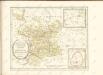
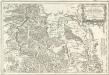
Tableau Topographique Qui comprend la Partie Septentrionale du Landgraviat de Hesse Cassel et de la Principauté de Waldeck, l'Eveché de Paderborn, Partie du Comté de Grubenhague et les Frontieres de ces Etats
1 : 130000 Mollova mapová sbírka Julien, Roch-Joseph Julien, Roch Joseph
334. Hoxter.
1 : 100000 Reichsamt fur Landesaufnahme
Composite: 334. Hoxter.
1 : 100000 Reichsamt fur Landesaufnahme
335. Einbeck.
1 : 100000 Reichsamt fur Landesaufnahme
Composite: 335. Einbeck.
1 : 100000 Reichsamt fur Landesaufnahme
Corbeiensis Dioecesis pro ut nunc est, descriptio noua
1 : 60000 Mollova mapová sbírka Gigas, Johann Michael
Corbeiensis Dioecesis pro ut nunc est, descriptio noua
1 : 60000 Mollova mapová sbírka Gigas, Johann Michael
Meßtischblatt 2522 : Duderstadt, 1937
1 : 250000 Duderstadt. - Hrsg. 1910, einz. Nachtr. 1927, [gedr.] [19]34, redakt. Änd. [19]37. - 1:25000. - [Berlin]: Reichsamt für Landesaufnahme, 1937. - 1 Kt.
Meßtischblatt 2522 : Duderstadt, 1878
1 : 250000 Duderstadt. - Aufn. 1876. - 1:25000. - [Berlin]: Reichsamt für Landesaufnahme, 1878. - 1 Kt.
Meßtischblatt 4426 : Waake, 1937
1 : 250000 Waake. - Aufn. 1908, Nachtr. 1919, redakt. Änd. [19]37. - 1:25000. - [Berlin]: Reichsamt für Landesaufnahme, 1937. - 1 Kt.
Meßtischblatt 2521 : Waake, 1878
1 : 250000 Waake. - Aufn. 1876. - 1:25000. - [Berlin]: Reichsamt für Landesaufnahme, 1878. - 1 Kt.
Meßtischblatt 2520, neue Nr. 4425 : Göttingen, 1939
1 : 250000 Göttingen. - Hrsg. 1910, einz. Nachtr. 1939. - 1:25000. - [Berlin]: Reichsamt für Landesaufnahme, 1939. - 1 Kt.
Meßtischblatt 2520 : Göttingen, 1931
1 : 250000 Göttingen. - Hrsg. 1910, einz. Nachtr. 1926. - 1:25000. - [Berlin]: Reichsamt für Landesaufnahme, 1926. - 1 Kt.
Meßtischblatt 2520 : Göttingen, 1891
1 : 250000 Göttingen. - Aufn. 1876, hrsg. 1878, einzelne Nachtr. 1891. - 1:25000. - [Berlin]: Reichsamt für Landesaufnahme, 1891. - 1 Kt.
Meßtischblatt 2520 : Göttingen, 1878
1 : 250000 Göttingen. - Aufn. 1876. - 1:25000. - [Berlin]: Reichsamt für Landesaufnahme, 1878. - 1 Kt.
Meßtischblatt Dransfeld
1 : 250000 Dransfeld. - Aufn. 1898, redakt. Änd. [19]37. - 1:25000. - [Berlin]: Reichsamt für Landesaufnahme, 1937. - 1 Kt.
Meßtischblatt 2518 : Ödelsheim, 1926
1 : 250000 Ödelsheim. - Aufn. 1896, einz. Nachtr. 1926. - 1:25000. - [Berlin]: Reichsamt für Landesaufnahme, 1926. - 1 Kt.
Meßtischblatt 2518 : Ödelsheim, 1898
1 : 250000 Ödelsheim. - Aufn. 1896. - 1:25000. - [Berlin]: Reichsamt für Landesaufnahme, 1898. - 1 Kt.
Meßtischblatt 2517 : Trendelburg, 1898
1 : 250000 Trendelburg. - Aufn. 1896. - 1:25000. - [Berlin]: Reichsamt für Landesaufnahme, 1898. - 1 Kt.
Meßtischblatt 2449, neue Nr. 4327 : Gieboldehausen, 1937
1 : 250000 Gieboldehausen. - Hrsg. 1910, einz. Nachtr. 1937. - 1:25000. - [Berlin]: Reichsamt für Landesaufnahme, 1937. - 1 Kt.
Meßtischblatt 4327 : Gieboldehausen, 1910
1 : 250000 Gieboldehausen. - Aufn. 1908. - 1:25000. - [Berlin]: Reichsamt für Landesaufnahme, 1910. - 1 Kt.
Meßtischblatt 4327 : Gieboldehausen, 1878
1 : 250000 Gieboldehausen. - Aufn. 1876. - 1:25000. - [Berlin]: Reichsamt für Landesaufnahme, 1878. - 1 Kt.
Meßtischblatt 2448 : Lindau, 1937
1 : 250000 Lindau. - Hrsg. 1910, einz. Nachtr. 1937. - 1:25000. - [Berlin]: Reichsamt für Landesaufnahme, 1937. - 1 Kt.
Meßtischblatt 2448 : Lindau, 1910
1 : 250000 Lindau. - Aufn. 1908. - 1:25000. - [Berlin]: Reichsamt für Landesaufnahme, 1910. - 1 Kt.
Meßtischblatt 4326 : Lindau, 1878
1 : 250000 Lindau. - Aufn. 1876. - 1:25000. - [Berlin]: Reichsamt für Landesaufnahme, 1878. - 1 Kt.
Meßtischblatt 2447 : Nörten, 1937
1 : 250000 Nörten. - Hrsg. 1910, einz. Nachtr. 1937. - 1:25000. - [Berlin]: Reichsamt für Landesaufnahme, 1937. - 1 Kt.
Meßtischblatt 2447 : Nörten, 1925
1 : 250000 Nörten. - Aufn. 1908, einz. Nachtr. 1925. - 1:25000. - [Berlin]: Reichsamt für Landesaufnahme, 1925. - 1 Kt.
Meßtischblatt 2447 : Nörten, 1910
1 : 250000 Nörten. - Aufn. 1908. - 1:25000. - [Berlin]: Reichsamt für Landesaufnahme, 1910. - 1 Kt.