Maps of Landkreis Cuxhaven

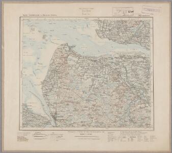
39. Bremerhaven, uit: Topographische Uebersichtskarte des Deutschen Reiches / herausgegeben v. d. Kartogr. Abt. d. Königl. Preuß. Landesaufnahme
1 : 200000 titelvariant: Topogr. Übersichtskarte des Deutschen Reiches; Annotatie: Titel boven bladen ook: Topogr. Übersichtskarte des Deutschen Reiches; Annotatie geografische gegevens: Op elk blad twee maatstokken: 10 Kilometer = 5,5 cm; 1 geogr. Meile = 3,6 cm; Legenda onder op elk blad Königlich Preußische Landesaufnahme. Kartographische Abtheilung [S.l : Königlich Preußische Landesaufnahme, Kartographische Abtheilung]
Celeberrimi Fluvii Albis nova delineatio [Karte, Teil 2], in: Theatrum orbis terrarum, sive, Atlas novus, Bd. 1, S. 182.
1 Karte aus Atlas Blaeu, Joan Blaeu, Willem Janszoon
Celeberrimi Fluvii Albis nova delineatio [Karte, Teil 2], in: Le théâtre du monde, ou, Nouvel atlas contenant les chartes et descriptions de tous les païs de la terre, Bd. 1, S. 148.
1 Karte aus Atlas Blaeu, Willem Janszoon und Blaeu, Joan Blaeu, Willem Janszoon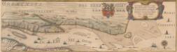
Celeberrimi Fluvii Albis nova delineatio [Karte, Teil 2], in: Novus Atlas, das ist, Weltbeschreibung, Bd. 1, S. 117.
1 Karte aus Atlas Blaeu, Joan Blaeu, Willem Janszoon
111. Otterndorf. (Germany)
1 : 100000 Reichsamt fur Landesaufnahme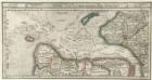
Gluckstatt mitt dero Gegend Westwerth und von daar die Elbe vollend hinnab zufahren bis in die Westsee, sampt dem Hamburgischen Ampt Ritzbuttel.
1 : 310000 Mollova mapová sbírka Bodenehr, Gabriel Bodenehr, Gabriel
Composite: 111. Otterndorf. (Germany)
1 : 100000 Reichsamt fur Landesaufnahme
110. Cuxhaven. (Germany)
1 : 100000 Reichsamt fur Landesaufnahme
Composite: 110. Cuxhaven. (Germany)
1 : 100000 Reichsamt fur Landesaufnahme
Composite: 143. Bremerhaven. (Germany)
1 : 100000 Reichsamt fur Landesaufnahme
144. Osten. (Germany)
1 : 100000 Reichsamt fur Landesaufnahme
143. Bremerhaven. (Germany)
1 : 100000 Reichsamt fur Landesaufnahme
Nordsee
1 : 25000 Cuxhaven (Německo) Reichs-Marine-Amt
Nordsee
1 : 50000 Cuxhaven (Německo) Reichs-Marine-Amt
Nordsee
1 : 25000 Glückstadt (Německo) Reichs-Marine-Amt
Meßtischblatt 1025 : Mulsum, 1899
1 : 250000 Mulsum. - Aufn. 1897. - 1:25000. - [Berlin]: Reichsamt für Landesaufnahme, 1899. - 1 Kt.
Meßtischblatt Ebersdorf
1 : 250000 Ebersdorf. - Aufn. 1897. - 1:25000. - [Berlin]: Reichsamt für Landesaufnahme, 1899. - 1 Kt.
Meßtischblatt 1023 : Köhlen, 1899
1 : 250000 Köhlen. - Aufn. 1897. - 1:25000. - [Berlin]: Reichsamt für Landesaufnahme, 1899. - 1 Kt.
Meßtischblatt 1022 : Bramel, 1893
1 : 250000 Bramel. - Aufn. 1891. - 1:25000. - [Berlin]: Reichsamt für Landesaufnahme, 1893. - 1 Kt.
Meßtischblatt 1021 : Bremerhaven, 1918
1 : 250000 Bremerhaven. - Aufn. 1891, hrsg. 1892, Auflagedr. 1918. - 1:25000. - [Berlin]: Reichsamt für Landesaufnahme, 1918. - 1 Kt.
Meßtischblatt 1021 : Bremerhaven, 1917
1 : 250000 Bremerhaven. - Aufn. 1891, hrsg. 1892. - 1:25000. - [Berlin]: Reichsamt für Landesaufnahme, 1917. - 1 Kt.
Meßtischblatt Stollhamm
1 : 250000 Stollhamm. - Aufn. 1891, hrsg. 1892, Auflagedr. 1917. - 1:25000. - [Berlin]: Reichsamt für Landesaufnahme, 1917. - 1 Kt.
Meßtischblatt 928 : Lamstedt, 1899
1 : 250000 Lamstedt. - Aufn. 1891. - 1:25000. - [Berlin]: Reichsamt für Landesaufnahme, 1899. - 1 Kt.
Meßtischblatt Bederkesa
1 : 250000 Bederkesa. - Aufn. 1891. - 1:25000. - [Berlin]: Reichsamt für Landesaufnahme, 1899. - 1 Kt.
Meßtischblatt 926 : Neuenwalde, 1893
1 : 250000 Neuenwalde. - Aufn. 1891. - 1:25000. - [Berlin]: Reichsamt für Landesaufnahme, 1893. - 1 Kt.
Meßtischblatt 2317 : Dorum, 1897
1 : 250000 Dorum. - Aufn. 1891, hrsg. 1893, einz. Nachtr. 1897. - 1:25000. - [Berlin]: Reichsamt für Landesaufnahme, 1897. - 1 Kt.
Meßtischblatt 924 : Schmarren, 1917
1 : 250000 Schmarren. - Aufn. 1891, hrsg. 1892. - 1:25000. - [Berlin]: Reichsamt für Landesaufnahme, 1917. - 1 Kt.
Meßtischblatt 832 : Hamelwörden, 1898
1 : 250000 Hamelwörden. - Aufn. 1897, hrsg. 1898. - 1:25000. - [Berlin]: Reichsamt für Landesaufnahme, 1898. - 1 Kt.
Meßtischblatt 831 : Kadenberge, 1925
1 : 250000 Kadenberge. - Aufn. 1878/1897, Nachtr. 1925. - 1:25000. - [Berlin]: Reichsamt für Landesaufnahme, 1925. - 1 Kt.