Maps of Südangeln

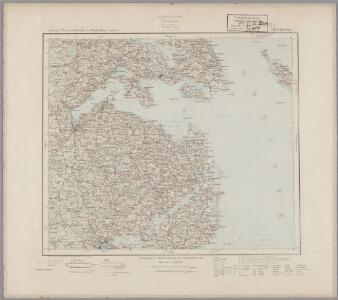
10. Schleswig, uit: Topographische Uebersichtskarte des Deutschen Reiches / herausgegeben v. d. Kartogr. Abt. d. Königl. Preuß. Landesaufnahme
1 : 200000 titelvariant: Topogr. Übersichtskarte des Deutschen Reiches; Annotatie: Titel boven bladen ook: Topogr. Übersichtskarte des Deutschen Reiches; Annotatie geografische gegevens: Op elk blad twee maatstokken: 10 Kilometer = 5,5 cm; 1 geogr. Meile = 3,6 cm; Legenda onder op elk blad Königlich Preußische Landesaufnahme. Kartographische Abtheilung [S.l : Königlich Preußische Landesaufnahme, Kartographische Abtheilung]
TERRITORIA | ANGLEN | ET | SCHWANSEN | Anno 1649
Matthias und Clauss Petersen Goldtschmide und gebr. | Hus. Cimb. sculps. [Amsterdam : Joan Blaeu]
Praefectvra Flensbvrgensis absque Nordgoeßherde
1 : 110000 Mollova mapová sbírka Mejer, Johannes Peters, Matthias Blaeu, Joan I.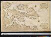
Nieuwe afteekening van het eijlandt Alsen en de vaste kust daar agter geleegen : vertoonende de rivieren van Apenrader en Flensborgh, is geleegen aen de west kust in de Belt Zee
Denmark Gerard van Keulen
PRÆFECTVRA | FLENSBVRGENSIS | absque Nordgoeßherde.
Matthias & Nicolas Peters Goldtschmide | gebr. Husum. sculps. [Amsterdam : Joan Blaeu]
DVCATVS | SONDERBORG | cum adjacentibus Territoriis | ALSSEN, SVNDEWITT, | et Luxburgh.
Matthis Peterss G.s. v. | Claus P. Goldtschmide unt gbr. | Huss. Cimbr. sculp. [Amsterdam : Joan Blaeu]
PRÆFECTVRÆ | GOTTORPIENSIS | pars Borealis.
Matthias und Clauss Petersen | Goldtschmide gebr. Hus. sculps. [Amsterdam : Joan Blaeu]
Composite: 24. Augustenburg. (Germany)
1 : 100000 Reichsamt fur Landesaufnahme
23. Flensburg. (Germany)
1 : 100000 Reichsamt fur Landesaufnahme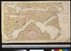
Afteekening van de Rivier van Sleeswijck waer bij dessefls incomen int grood wort vertoont geleegen in de Beldt
Germany Gerard van Keulen
38. Schleswig. (Germany)
1 : 100000 Reichsamt fur Landesaufnahme
Composite: 23. Flensburg. (Germany)
1 : 100000 Reichsamt fur Landesaufnahme
24. Augustenburg. (Germany)
1 : 100000 Reichsamt fur Landesaufnahme
39. Kappeln. (Germany)
1 : 100000 Reichsamt fur Landesaufnahme
Composite: 38. Schleswig. (Germany)
1 : 100000 Reichsamt fur Landesaufnahme
Composite: 39. Kappeln. (Germany)
1 : 100000 Reichsamt fur Landesaufnahme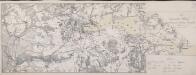
Die Dannewerks-Stellung
1 : 40000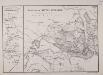
Plan von der Düppel-Stellung
1 : 33000 Liebenow, Wilhelm Schropp
Karte der Umgegend von Düppel und Sonderburg, sowie von der Westküste der Insel Alsen mit den Dänischen Befestigungen und den Preussischen Belagerungs-Arbeiten 1864
1 : 25000
Meßtischblatt 254 : Dorotheenthal, 1919
1 : 250000 Dorotheenthal. - Aufn. 1877, hrsg. 1879, Aufldr. 1919. - 1:25000. - [Berlin]: Reichsamt für Landesaufnahme, 1919. - 1 Kt.
Meßtischblatt 253 : Sieseby, 1888
1 : 250000 Sieseby. - Aufn. 1877, hrsg. 1879, einz. Nachtr. 1888. - 1:25000. - [Berlin]: Reichsamt für Landesaufnahme, 1888. - 1 Kt.
Meßtischblatt 252 : Brodersby, 1879
1 : 250000 Brodersby. - Aufn. 1877. - 1:25000. - [Berlin]: Reichsamt für Landesaufnahme, 1879. - 1 Kt.
Meßtischblatt 251, neue Nr. 1423 : Schleswig, 1937
1 : 250000 Schleswig. - Hrsg. 1879, bericht. 1926, einz. Nachtr. 1929, mehrfarb. Ausg. 1933. - 1:25000. - [Berlin]: Reichsamt für Landesaufnahme, 1937. - 1 Kt.
Meßtischblatt 250 : Jübek, 1919
1 : 250000 Jübek. - Aufn. 1877, kleine Nachtr. 1919. - 1:25000. - [Berlin]: Reichsamt für Landesaufnahme, 1919. - 1 Kt.
Meßtischblatt 210 : Schönhagen, 1920
1 : 250000 Schönhagen. - Aufn. 1877, hrsg. 1879, Aufldr. 1920. - 1:25000. - [Berlin]: Reichsamt für Landesaufnahme, 1920. - 1 Kt.
Meßtischblatt 209 : Kappeln, 1891
1 : 250000 Kappeln. - Aufn. 1877, hrsg. 1879, einz. Nachtr. 1891. - 1:25000. - [Berlin]: Reichsamt für Landesaufnahme, 1891. - 1 Kt.
Meßtischblatt 208 : Süderbrarup, 1900
1 : 250000 Süderbrarup. - Aufn. 1877, hrsg. 1879, einz. Nachtr. 1900. - 1:25000. - [Berlin]: Reichsamt für Landesaufnahme, 1900. - 1 Kt.
Meßtischblatt 207 : Ülsby, 1902
1 : 250000 Ülsby. - Aufn. 1877, hrsg. 1879, einz. Nachtr. 1902. - 1:25000. - [Berlin]: Reichsamt für Landesaufnahme, 1902. - 1 Kt.
Meßtischblatt 206 : Eggebek, 1896
1 : 250000 Eggebek. - Aufn. 1877, hrsg. 1879, einz. Nachtr. 1896. - 1:25000. - [Berlin]: Reichsamt für Landesaufnahme, 1896. - 1 Kt.