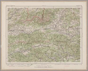
Maps of District of Brezno

Leutschau 121, uit: Special-Karte von Mittel-Europa / nach amtlichen Quellen bearbeitet von W. Liebenow
1 : 300000 titelvariant: W. Liebenow's Mittel-Europa; Annotatie: Titel boven de bladen: W. Liebenow's Mittel-Europa Johannes Wilhelm Liebenow 1822-1897 Frankfurt a. M. : Ludwig Ravenstein
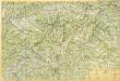
Die Central-Karpaten
1 : 200000 Karpaty Sydow, A. von Wolff
Kirchen, Klöster und Burgen in spätromanischer Zeit (nach V. Mancl)
Zips Baudenkmal
Deutsches Volksgebiet in der Zips
Zips ethnische Gruppe, Deutsche
Jonction du Waag au Poprad
1 : 420000 Poprad-oblast (Slovensko)
Mappa physico-geographica Carpatorum principalium e quibus Wagus et Dunajetz origines trahunt
1 : 190000 Tatry (Polsko a Slovensko) Bojtár, St.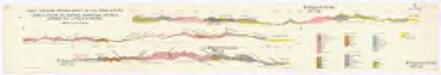
Profily Centrálními Západními Karpaty na listu Báňská Bystrica
1 : 50000 Banská Bystrica (Slovensko : oblast) V. Neubert a synové
Vysoké Tatry
Podrobná mapa Vysokých Tater
1 : 25000 Vysoké Tatry, pohoří-oblast (Polsko a Slovensko) Čs. voj. zeměpisný ústav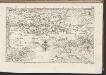
C. Liptoviensis
Slowakei Komitat Liptau
Das Zipser Gebiet
1 : 2000000 Zips
Slovenský raj

Quellencebiet Der Cran.
from Spezialkarte der osterreichisch-ungarischen Monarchie.
Hohe Tatra.
from Spezialkarte der osterreichisch-ungarischen Monarchie.
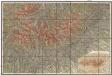
Umgebung von Zakopana
1 : 115000 Liptovský Mikuláš-oblast (Slovensko) Kummersberg, Carl von Artaria
Comitat-Liptau
1 : 288000 Liptov (Slovensko)
Comitat-Liptau
1 : 288000 Liptov (Slovensko)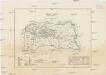
Comitat-Liptau
1 : 288000 Liptov (Slovensko)
Nízké Tatry – Východná časť

Nízké Tatry východná časť

Iglo und Mereny.
from Spezialkarte der osterreichisch-ungarischen Monarchie.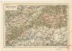
Oravsko-Liptovské hory
Slovenské rudohorie
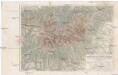
Terrain- und Höhenkarte der Hohen Tatra in den Central-Karpaten
1 : 100000 Vysoké Tatry, pohoří (Polsko a Slovensko) Kořistka, Karel František Edvard Petermann, August Justus Perthes
Terrain- und Höhenkarte der Hohen Tatra in den Central-Karpaten
1 : 100000 Vysoké Tatry, pohoří (Polsko a Slovensko) Kořistka, Karel František Edvard Petermann, August Justus Perthes
Levoča
1 : 75000 Levoča (Slovensko) Vojenský zeměpisný ústav
Levoča a Kežmarok
1 : 75000 Kežmarok (Slovensko : oblast) Vojenský zeměpisný ústav
Levoča a Kežmarok
1 : 75000 Kežmarok (Slovensko : oblast) Vojenský zeměpisný ústav