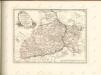
Maps of powiat grójecki

Radom 65, uit: Special-Karte von Mittel-Europa / nach amtlichen Quellen bearbeitet von W. Liebenow
1 : 300000 titelvariant: W. Liebenow's Mittel-Europa; Annotatie: Titel boven de bladen: W. Liebenow's Mittel-Europa Johannes Wilhelm Liebenow 1822-1897 Frankfurt a. M. : Ludwig Ravenstein
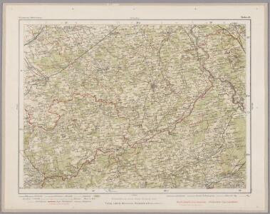
Grójec und Warka
1 : 75000 Tschofen, F. K. u. k. Militärgeographisches Institut
Mszczonów
1 : 75000 Meier, J. K. u. k. Militärgeographisches Institut
Nowe Miasto
1 : 75000 Triltsch, K. K. u. k. Militärgeographisches Institut
Białobrzegi und Głowaczew
1 : 75000 Mühlberger, J. K. u. k. Militärgeographisches Institut
Skierniewice
1 : 75000 Skierniewice (Polsko) Bayer, R. K. u. k. Militärgeographisches Institut
Tomaszów
1 : 75000 Polsko Karbiutz, F. K. u. k. Militärgeographisches Institut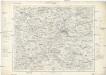
Radom
1 : 75000 Radom-oblast (Polsko) K. u. k. Militärgeographisches Institut
Radom
1 : 75000 Radom-oblast (Polsko) K. u. k. Militärgeographisches Institut
Kriegs Atlas 36 Karten von den Schauplätzen des Weltkrieges 1914/1915

Warszawa, Brest-Litowsk, Radom, Lublin, Kielze, Tomaszów

Mapa fizyczna okolic Warszawy
1 : 400000 Varšava-oblast (Polsko) Inst. Wojsk. Geograficznego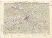
Mapa topograficzna okolic Warszawy
1 : 100000 Varšava-oblast (Polsko) Wojskowy instytut geograficzny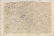
Karte der Umgegend von Warschau
1 : 100000 Varšava-oblast (Polsko) Kartogr. Abteilung des Stellvertretenden Generalstabes des Armee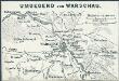
Umgegend von Warschau
1 : 200000 Warschau, Umland
Der Durchbruch bei Brzeziny 21. bis 23. November 1914
Brzeziny Schlacht
Übersicht des österrechisch-russischen Kriegsschauplatzes

Karte des westlichen Russlands

Przysucha
1 : 75000 Polsko K. u. k. Militärgeographisches Institut
Karte des westlichen Russlands

Kozienice
1 : 75000 Peia, Georg K. u. k. Militärgeographisches Institut
Opoczno
1 : 75000 Opoczno-oblast (Polsko) K. u. k. Militärgeographisches Institut
Garwolin
1 : 75000 Mor Sunneg und Morberg, E. von K. u. k. Militärgeographisches Institut
Wyrazenie ostatniey Batalii Polaków z Moskalami w roku 1794 odprawioncy pod wsią Maciejowicami, gdiu nacielnik Kosciuszko z malą kwotą woyska obozem stoiąc, otoczony został od daleko licznieyszego nieprzyiaciela, start sięz nim możnie, lecz gdy putki krolewskie z prawego skrzydla pierzchty, do ostatka się broniac, raniony i do niewoli zabrany został
Szczepanowski, K.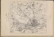
Šturm Varšavy. 1-j den' 26 avgusta-6 sentjabrja 1831 goda
Polen Warschau Novemberaufstand <1830-1831>
[Warschau]
1 : 350000 Warschau Belagerung, Weltkrieg <1914-1918>
Warschau, Lublin, Modlin (Nowogeorgiewsk)
1 : 750000 Lublin (Polsko : oblast) Karl, E. K. u. k. Militärgeographisches Institut
Warschau, Lublin, Nowo-Georgiewsk
1 : 750000 Lublin (Polsko : oblast) K. k. militär-geographisches Institut
General-Carte von Westgallizien
1 : 291000 Polsko jihovýchodní Benedicti, Lucas