Maps of Utrecht

Amsterdam 55, uit: [W. Liebenow's Special-Karte von Mittel-Europa]
1 : 300000 titelvariant: W. Liebenow's Mittel-Europa; Annotatie: Titel boven de bladen: W. Liebenow's Mittel-Europa Johannes Wilhelm Liebenow 1822-1897 Hannover : Hermann Oppermann
Amsterdam 55, uit: Special-Karte von Mittel-Europa / nach amtlichen Quellen bearbeitet von W. Liebenow
1 : 300000 titelvariant: W. Liebenow's Mittel-Europa; Annotatie: Titel boven de bladen: W. Liebenow's Mittel-Europa Johannes Wilhelm Liebenow 1822-1897 Frankfurt a. M. : Ludwig Ravenstein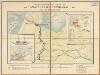
Amsterdam-Rheinkanal : frei von Kanalabgaben / [getekend door] J.H. Schmüll
1 : 250000 Annotatie: Boven de kaart: Handelskammer in Amsterdam; Met informatie over de Amsterdamse haven, het Noordzee-kanaal, het Amsterdam-Rijnkanaal en de scheepvaart over deze kanalen; Annotatie geografische gegevens: Inzetkrt.: 1. Doorsnede met laagste waterstand. - 1:250 ; 2. Amsterdam. - 1:25.000 ; 3. Holland-Deutschland, Verkehr auf dem Rhein, 1892. - 1:4.000.000 J.H. Schmüll [S.l. : s.n.] / (Amsterdam : Tresling & Co)
Utrecht, divisé en arrondissemens et cantons de justice de paix
1 : 180000 dressé et gravé par C. van Baarsel et fils. À La Haye : chez F.J. Weygand
Lignes d'eau de la Hollande
1 : 263000 [Lieu de publication inconnu] : [éditeur inconnu]
(No. V), uit: Choro-topographische kaart der Noordelijke Provinciën van het Koningrijk der Nederlanden / uitgevoerd aan het Topographisch Bureau van dezen Staat, volgens het ontwerp, de geodesische en astronomische waarnemingen van Baron Kraijenhoff
1 : 115200 Annotatie: Gestempeld r.o. in rood: AVO (=Archief van Oorlog); Lit.: J.A. van der Linden, Topographische en militaire kaart van het Koningrijk der Nederlanden. Bussum 1973. p. 9-16 & E. ten Brink, De grote kaart van Krayenhoff, speciaal p. 38-39; Op de bladwijzer staat de Hoofddriehoeksmeting aangegeven met de Alphabetische tafel der breedte en lengte van de standplaatsen; Annotatie geografische gegevens: Schaalstok van 27,77 Mylen (Kilomètres) of 7380 Rh. Roeden of 5 Uren (=23,7 cm), op schaal: 800 Rl. Roeden op den Rh. Duim of van 1,152 Myl (Kilomètre) op den Duim (Centimètre); Legenda r.o. op blad VII Topographisch Bureau, Den Haag; Archief van Oorlog, Den Haag ['s-Gravenhage : Topographisch Bureau, Archief van Oorlog]
Kaart van de provincie Utrecht verdeeld in arrondissementen en regterlijke kantons, ingevolge besluit van Z.M. den Koning der Nederlanden = Province d’Utrecht, divisée en arrondissemens et cantons judiciaires par arrêté de S.M. le Roi des Pays-Bas
dressée gravée et publiée par F. Desterbecq, vu par le Cadastre. La Haye : Établissement Géographique de F. Desterbecq
No. V, uit: Choro-topographische kaart der Noordelijke Provincien van het Koningrijk der Nederlanden / uitgevoerd aan het Topographisch Bureau van dezen staat ; volgens het ontwerp, de geodetische en astronomische waarnemingen van den Luitenant Generaal Baron Krayenhoff
1 : 115200 titelvariant: Generale kaart van het Koningrijk Holland; Chorographische kaart van Holland vereenigd met het Fransche Rijk; Carte chorographique des Departemens de la Hollande; Annotatie: Voor aanwezige bladen zie overzichtsblad; Blad Noord-Brabant ontbreekt Krayenhoff, C. R. T.; Ministerie van Oorlog. Topographisch Bureau ['s-Gravenhage : Archief van Oorlog]
Utrecht, uit: Sterfte-atlas van Nederland over 1860-1874 / [uitgave van de Nederlandsche Maatschappij tot Bevordering der Geneeskunst]
titelvariant: Sterfte-atlas van Nederland; Annotatie: Alleen kaartbijlage aanwezig Pieter Harmen Witkamp 1816-1892; Nederlandsche Maatschappij tot Bevordering der Geneeskunst Amsterdam : van Rossen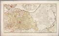
Tabula nova provinciæ Ultrajectinæ / quam jussu Nob. hujus Dominij Ordinum emensus est Bernardus du Roy geometra et in lucem edidit Nicol. Visscher
1 : 140000 Annotatie: Cum Privilegio Præpot. et. Nob. Ordinum F?derati Belgii; Oorspr. uitg.: [Amsterdam] : Nicol. Visscher, [1698]; Annotatie geografische gegevens: 2 schaalstokken: [0] - 2 twee uren gaans (= 7,8 cm) en [0] - 2 twee gemene Duytsche mylen van 15 in een graad (= 10,4 cm) Nicolaes Jansz. Visscher jr. 1649-1702; Luggert van Anse 1690-1716 werkzaam [Amsterdam : nunc apud Petrum Schenk Junior] / ([S.l. : L. van Anse schulp])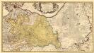
Tabula nova Provinciae Ultrajectinae
1 : 140000 Mollova mapová sbírka Du Roy, Bernardus Schenk, Peter II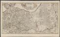
Tabula nova provinciae Ultrajectinae
quam jussu nob. hujus dominij ordinum emensus est Bernardus du Roy geometra, et in lucem edidit Nicol. Visscher L. van Anse schulp. [Amsterdam] : nunc apud Petrum Schenk Junior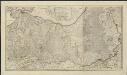
Tabula nova provinciae Ultrajectinae
1 : 120000 quam jussu nob. hujus dominii ordinum emensus est Bernardus du Roy geometra, et in lucem edidit Nicol: Visscher L. van Anse schulp. [Amsterdam] : nunc apud Petrum Schenk Junior
Ultraiectum Dominium
1 : 415000 Petrus Kærius cælavit. [Amsterdam] : [Jan Evertsz. Cloppenburgh]
Nieuwe kaart van den Lande van Utrecht
1 : 44000 volgens ordre van d'Ed. Mog. Heeren Staten van welgemelden lande doen meten, en in kaart brengen, door Bernard du Roy G. Hoet, del. ornam. ; T. Doesburgh, sculps. Tot Amsterdam : door Johannes Covens en Cornelis Mortier
Ultraiectini Dominii Tabula [Karte], in: Novus atlas absolutissimus, Bd. 3, S. 203.
1 Karte aus Atlas Janssonius Offizin
Ultraiectini Dominii tabula / multo aliis auctior et correctior per Nic. Visscher ; R. de Hooghe fecit
1 : 180000 Annotatie: Origineel is Blad 55 in atlas factice; Annotatie geografische gegevens: Zuidwest boven; Met 3 schaalstokken Nicolaes Jansz Visscher sr 1618-1679; Romeyn de Hooghe 1645-1708 [Amsterdam : Nicolaes Visscher]
[99][100] Ultraiectini Dominii tabula, uit: Atlas sive Descriptio terrarum orbis
Annotatie: Gedigitaliseerde versie. Amsterdam. Heiloo : Picturae (vervaardiger), 2015. tiff-bestand. Gedigitaliseerd: 07-01-2015; Origineel: Universiteitsbibliotheek Vrije Universiteit (XL.05127.-) ; Netherlands; Titelpagina ontbreekt Wit, Frederik de Amsterdam : Frederick de Wit
Ultraiectini Dominii tabula multo aliis auctior et correctior
1 : 100000 per F. de Wit. Tot Amsterdam : by Frederick de Wit ...
Ultraiectini Dominii tabula
1 : 120000 multo aliis auctior et correctior per F. de Wit. T'Amsterdam : by J. Covens en C. Mortier

Ultraiectini Dominii tabula
1 : 120000 multo aliis auctior et correctior per I. Danckerts. Tot Amsterdam : by Justus Danckers
14. Rijnland, uit: Geologische kaart van Nederland / door W.C.H. Staring ; bew. aan de Topographische Inrichting
1 : 200000 Winand Carel Hugo Staring 1808-1877; Topographische Inrichting, 's-Gravenhage 's-Gravenhage : Belinfante
14me Utrecht, uit: [Nouvelle carte de la Hollande, d'après Kraijenhoff et les meilleures cartes connus] / [Ph. Vandermaelen]
1 : 130000 Annotatie: Ontbreekt: bl. 1-12 Vandermaelen, Philippe Marie Guillaume Bruxelles : Établissement Géographique
Ultraiectini Dominii tabula
1 : 120000 multo aliis auctior et correctior per Nic. Visscher R. de Hooghe fecit. [Amsterdam] : [N. Visscher]
Rhinolandiæ Amstelandiæ et circumjacent. aliquot territoriû accurata descriptio
1 : 360000 Auctore Balth. Florentio a Berckenrode. Amstelodami : sumptibus Henrici Hondii.
La Rhinlande Amstellande et terres circõvosines
1 : 300000 auctore Balt[hasar] Flo: a Berkêrode. [Amsterdam] : [Jacob Aertsz. Colom]
La Seigneurie D'Utrecht [Karte], in: Atlas nouveau, contenant toutes les parties du monde [...], Bd. 2, S. 79.
1 Karte aus Atlas Sanson, Nicolas Jaillot, Alexis Hubert und Mortier, Pieter
Carte von Utrecht / entworfen von F.L. Güssefeld
1 : 125000 titelvariant: Carte geographique de la Province d'Utrecht; Annotatie: Titel boven de kaart: Carte geographique de la Province d'Utrecht; Annotatie geografische gegevens: West boven Güssefeld, F. L. Nürnberg : bey den Hom. Erben
![Amsterdam 55, uit: [W. Liebenow's Special-Karte von Mittel-Europa]](https://images-2.georeferencer.com/images/iiif/525686059952/full/,300/0/native.jpg)

