Maps of Dubrovnik-Neretva County

G.8. Cattaro, uit: [Übersichtskarte von Europa 1:750.000]
1 : 750000 Wien : K.u.K. Militärgeographisches Institut
Bez titulu: Istrie a Dalmatské pobřeží

[Západní pobřeží Chorvatska]
1 : 864000 Chorvatsko Lanée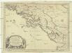
Coste de Dalmacie ou sont remarquees les places qui appartiennent a la republique di Venise, a la republique de Raguse et au grand seign. des Turqs
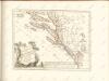
Dalmácie (Chorvatsko) Sanson, Nicolas Mariette, Pierre Pierre Mariette
[Nordalbanien]
Albanien
Totius Graeciae descriptio
Griechenland Albanien
Coste de Dalmacie ou sont remarquees les places qui appartiennent a la Republique de Venise, a la Republique de Raguse, et au Grand Seignr des Turqs tirée de divers autheurs
1 : 880000 Dalmatien, Montenegro Sanson, Guillaume
Südlicher Teil von Dalmatien
Dalmatien (Süd)
Speculum orbis Terrarum
Albanien
Urbinas Handschrift
Albanien Trattato della pittura / Handschrift / Rom / Vatikanische Bibliothek / Cod. Urb. Lat.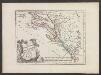
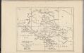
Der Südliche Theil des Koenigreichs Dalmatien mit der Republik Ragusa
1 : 1000000 Dalmatien, Dubrovnik
Übersichtskarte von Mittel - Europa

Karte des Operations-Gebietes in Süd-Dalmatien (Crivoscie-Bocche di Cattaro) und der Herzegovina, nebst dem angrenzenden Fürstenthum Montenegro
1 : 325000 Dalmácie (Chorvatsko) A. Hartleben's Verlag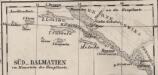
Süd-Dalmatien
Dalmatien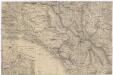
[Montenegro und angrenzende Länder]
Bělehrad (Srbsko : oblast)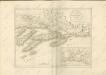
Montenegro
Montenegro
Karta Crnegore
1 : 289000 Černá Hora Karacsay, Fedor de Allodi, P.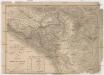
Karta Crnegore
1 : 289000 Černá Hora Karacsay, Fedor de
Hypsometrische uibersichtskarte von Bosnien der Herzegovina von Serbien und Montenegro
Carta di Montenegro (Crna gora)
1 : 300000 Montenegro Paulini, Giacomo
Ragusa, Mostar
1 : 750000 Dubrovník (Chorvatsko : oblast) Nimmerfroh, J. K. u. k. Militärgeographisches Institut
Ragusa, Mostar
1 : 750000 Dubrovník (Chorvatsko : oblast) K. u. k. militär-geografisches Institut
Ragusa, Mostar
1 : 750000 Dubrovník (Chorvatsko : oblast) K. k. militär-geographisches Institut
XVIII, uit: General-Karte des oesterreichischen Kaiserstaates mit einem grossen Theile der angrenzenden Länder / durch Josef Scheda ... bearb. und hrsg
1 : 576000 Annotatie geografische gegevens: Maatstokken: oesterreichische Meilen, geografische oder deutsche Meilen, preussische Meilen, türkische Berri, französische Lieues, russische Werste; Maatstok per blad: wiener Klafter, öster. Meilen; Blad XIX: statistische en taalkundige informatie; Blad XIX: legenda [Wien : K.K. Militärisch-Geografisches Institut]
Carte de la Haute Albanie ou Guegaria. Comprenant le Pachalik de Scutari avec une partie de ceux de Monastir et de Prisren
Shkodër Ejalet
Tabula Peutringeriana
Albanien Peutingersche Tafel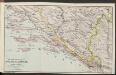
Die adriatische Küste von Spalato bis Cattaro
1 : 900000 Kroatien Adriaküste
![G.8. Cattaro, uit: [Übersichtskarte von Europa 1:750.000]](https://images-2.georeferencer.com/images/iiif/130501536809/full/,300/0/native.jpg)

