Maps of Velden

26 Velden, uit: De Tranchotkaart van het gebied tussen Maas en Rijn : Nederlands gedeelte
Annotatie: Omslagtitel; Facs. van het Nederlandse deel van de manuscriptkaart van het Rijnland vervaardigd o.l.v. Jean Joseph Tranchot, 1803-1820. - Gereduceerd van 1:20.000 tot 1:25.000 Jean Joseph Tranchot 1752-1815 [Maastricht : Stichting Maaslandse Monografieën]
Venloa
[Nicolaas van Geelkercken] [S.l.] : [s.n.]
VENLOA
[Amsterdam : Joan Blaeu]
Messtischblatt 2571 : Straelen, 1893
1 : 250000 Straelen. - Aufn. 1892, hrsg. 1893, bericht. 1907. - 1:25000. - [Berlin]: Reichsamt für Landesaufnahme, 1907. - 1 Kt.
Bijlage 5, uit: Eindverslag over de onderzoekingen en uitkomsten van den Dienst der Rijksopsporing van Delfstoffen in Nederland, 1903-1916
Annotatie: Met lit. opg Departement van Landbouw, Nijverheid en Handel. Dienst der Rijksopsporing van Delfstoffen ['s-Gravenhage : Martinus Nijhoff]
Bl. 34 Venlo, 1904, uit: Atlas A.N.W.B.
1 : 200000 titelvariant: Atlas van Nederland van den A.N.W.B. Toeristenbond voor Nederland; Wielrijders-atlas van Nederland; Annotatie: Titel op bladwijzer: Atlas van Nederland van den A.N.W.B. Toeristenbond voor Nederland; Titel op legendablad: Wielrijders-atlas van Nederland; Voor aanwezige bladen zie overzichtsblad; Annotatie geografische gegevens: De serie bestaat uit 36 bladen ANWB ['s-Gravenhage : A.N.W.B.]
Tetrarchia Ducatus Geldriae Ruremondana Sive Hispanica
1 : 110000 Mollova mapová sbírka Wit, Frederik de Covens, Johannes I
[62][62] Comitatus Meursensis ..., uit: Atlas sive Descriptio terrarum orbis
Annotatie: Gedigitaliseerde versie. Amsterdam. Heiloo : Picturae (vervaardiger), 2015. tiff-bestand. Gedigitaliseerd: 07-01-2015; Origineel: Universiteitsbibliotheek Vrije Universiteit (XL.05127.-) ; Netherlands; Titelpagina ontbreekt Wit, Frederik de Amsterdam : Frederick de Wit
FOSSA SANCTÆ MARIÆ | quæ EVGENIANA dicitur Vulgo De Nieuwe Grift.
Excudit Guilj. Janßonius Blaeuw
Fossa Eugeniana quae a Rheno ad Mosam duci coepta est, anno MDCXXII ductu comitis Henrici vanden Berge / [Joannes Janssonius]
1 : 80000 Annotatie: Het eerst verschenen in: Novus Atlas, das ist, Weltbeschreibung ... Zweite Theil. - Amsterdami : apud Iohannem Ianssonium, 1645; Origineel is Blad 66 in atlas factice; Annotatie geografische gegevens: Noordwest boven Janssonius, Joannes (jr.) (1588-1664) Amstelodami : sumptibus Ioannis Ianssonii
Fossa Eugeniana quae a Rheno ad Mosam duci coepta est, Anno CICICCXXVII ductu Comitis Henrici vanden Berge. [Karte], in: Novus atlas absolutissimus, Bd. 3, S. 103.
1 Karte aus Atlas Janssonius Offizin
Fossa Eugeniana quae a Rheno ad Mosam duci coepta est, Anno CICICCXXVII ductu Comitis [...] [Karte], in: Gerardi Mercatoris et I. Hondii Newer Atlas, oder, Grosses Weltbuch, Bd. 1, S. 413.
1 Karte aus Atlas Mercator, Gerhard und Hondius, Jodocus Jansson, Jan
Fossa quae a Rheno ad Mosam duci coepta est, anno MDCXXII.
1 : 143000 Amsterdam : excudit Guilj. Janssonius Blaeuw
Fossa Sanctae Mariae, quae et Eugeniana dicitur Vulgo De Nieuwe Grift. [Karte], in: Novus Atlas, das ist, Weltbeschreibung, Bd. 1, S. 385.
1 Karte aus Atlas Blaeu, Joan Blaeu, Willem Janszoon
Fossa Sanctae Mariae, quae et Eugeniana dicitur Vulgo De Nieuwe Grist. [Karte], in: Le théâtre du monde, ou, Nouvel atlas contenant les chartes et descriptions de tous les païs de la terre, Bd. 1, S. 414.
1 Karte aus Atlas Blaeu, Willem Janszoon und Blaeu, Joan Blaeu, Willem Janszoon
Fossa Sanctae Mariae, quae et Eugeniana dicitur Vulgo De Nieuwe Grist. [Karte], in: Theatrum orbis terrarum, sive, Atlas novus, Bd. 1, S. 413.
1 Karte aus Atlas Blaeu, Joan Blaeu, Willem Janszoon
23me Helmont, uit: Nouvelle carte de la Hollande, d'après Kraijenhoff et les meilleures cartes connues / Établissement Géographique de Bruxelles, fondé par Ph. Vander Maelen
1 : 117000 Annotatie: De bladen zijn genummerd 1-24. De bladen 2 t/m 24 hebben elk een afzonderlijke titel. Blad 5 bevat: Triangulations et positions. Blad 9 bevat: Plan d'Amsterdam; De kaartbladen 1, 5, 9 en 24 zijn niet ingekleurd; Van kaartblad 24 is een extra (ingekleurd) exempl. aanwezig; Annotatie geografische gegevens: 2 schaalstokken: 5 Echelle de 5 lieues de 20 au degré ... (= 23,2 cm) en 7380 Echelle de 5 lieues de 20 au degré ... (= 23,2 cm); Legenda; Met indexkaart: Carte d'assemblage Philippe Marie Guillaume Vander Maelen 1795-1869; Établissement Géographique de Bruxelles Bruxelles : Établissement Géographique
V ; 1.M., uit: Carte chorographique des Pays-Bas Autrichiens / ... par le Comte de Ferraris ; gravée par L.A. Dupuis
1 : 86400 Annotatie: Bladen linksboven genummerd met Romeinse cijfers, rechtsboven met een cijfer en een letter; Met opdracht aan keizer Joseph II (bl.XVI); Met plattegrond van Brussel (bl. XXI), overzichtskaart (bl. XXII) en bladwijzer (bl. XXIII); Annotatie geografische gegevens: Schaalstokken: Echelle de Toises ou de Lieues communes de France; Echelle de Verges ou de Lieues de Brabant; Echelle de Milles d'Allemagne (bl. XVII); Echelle de Mètres; In de hoeken lengte- en breedtematen T.M.e en T.P.e Joseph-Jean François Ferraris Comte de 1726-1814; L.A. Dupuis [S.l. : s.n.]

18, uit: Topografische atlas van het Koninkrijk der Nederlanden
Annotatie: Map met 19 losse krt. schaal 1:200.000 en 1 bladwijzer schaal 1:1.000.000 ['s-Gravenhage : Ministerie van Oorlog, Topografisch Bureau]
23. Peel, uit: Geologische kaart van Nederland : schaal van 1:200.000 / door W.C.H. Staring ; uitgevoerd door het Topographisch Bureau van Oorlog ; uitgegeven op last van Zijne Majesteit Den Koning
Annotatie: Impressum ontleend aan omslag; Kaart "Nederland de dijken weggedacht" [kaart 25] en kaart 13 (bladwijzer) vermelden het jaar 1869; Kaart 'Limburg en de Hesbaije' (bladnr. 26) vermeldt het jaar 1868; Blad 5/9 ontbreekt Topographische Inrichting, 's-Gravenhage; Topographisch Bureau Haarlem : A.C. Kruseman
23me Helmont, uit: [Nouvelle carte de la Hollande, d'après Kraijenhoff et les meilleures cartes connus] / [Ph. Vandermaelen]
1 : 130000 Annotatie: Ontbreekt: bl. 1-12 Vandermaelen, Philippe Marie Guillaume Bruxelles : Établissement Géographique
23. Peel, uit: Geologische kaart van Nederland / door W.C.H. Staring ; bew. aan de Topographische Inrichting
1 : 200000 Winand Carel Hugo Staring 1808-1877; Topographische Inrichting, 's-Gravenhage 's-Gravenhage : Belinfante
23. Peel, uit: Geologische kaart van Nederland / door W.C.H. Staring ; bew. aan de Topographische Inrichting
1 : 200000 Winand Carel Hugo Staring 1808-1877; Topographische Inrichting, 's-Gravenhage 's-Gravenhage : Belinfante
TETRARCHIA | Ducatus Gelriæ | RVRÆMVNDENSIS
[Amsterdam : Joan Blaeu]
IV, uit: Carte chorographique des Pays-Bas Autrichiens / ... par le Comte de Ferraris ; gravée par L.A. Dupuis
1 : 86400 Annotatie: Lit.: Les militaires et la cartographie des Pays-Bas méridionaux et de la Principauté de Liège à la fin du XVIIe et au XVIII siècle / Claire Lemoine-Isabeau. - Bruxelles, 1984, p. 206-212; La cartographie au XVIIIe siècle et l'oeuvre du Comte de Ferraris (1726-1814) : colloque international, Spa, 8-11 sept. 1976. - Bruxelles, 1978; Met opdracht aan keizer Joseph II (bl.XVI); Met plattegrond van Brussel (bl. XXI), overzichtskaart (bl. XXII) en bladwijzer (bl. XXIII); Ontbreekt: bl. I-III en XXI; Voor aanwezige bladen zie overzichtsblad Ferraris, Johann Joseph; Dupuis, L. A. [S.l. : s.n.]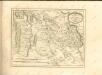

De tot de Synode van Gelderland behoorende twee generaliteits klassen van 's Bosch en van Peel en Kempenland
1 : 400000 door W.A. Bachiene ... J. van Jagen sculps. 1767. te Amsterdam : by D. onder de Linden
Kaart van het hertogdom Limburg
1 : 75000 vervaardigd met goedkeuring der Provinciale Staten volgens de uitkomsten van het kadaster door J.F. Bonniver ... geteekend door J.F.M. Bonniver zoon ; gegraveerd door L. Muller ... [S.l.] : [s.n.]


