Maps of Central Lowland

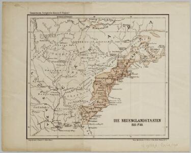
Die Neuenglandstaaten bis 1783
1 : 16000000 Berlin : Mittler
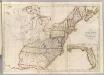
The United States of America, showing the boundaries fixed in 1782, five years before the ratification of the Constitution : from a contemporary copy of Benjamin Franklin's red-line map identified in Spain by the Library of Congress at Washington.
1 : 6860480 Facsimile of map published in Paris by Le Rouge and dated 1777. Relief shown pictorially. Inset letters of Aranda and Franklin printed in facsimile reflect the official use of the map in establishing United States boundaries. "Reprinted 1838 by U.S. Geological Survey." Includes text and inset: Nouvelle carte de la Baye dHudson et de Labrador selon las dernieres cartes levées sur les lieux. "This map is one of a series of similar colored maps, depicting the 13 original states from New Hampshire to Georgia at the time of the formation of the Constitution." John, Mitchel, 1711-1768 Washington, D.C. : United States Constitution Sesquicentennial Commission, [Washington, D.C.] : U.S. Geological Survey
A Map of Carolana and of the River Meschacebe &c.
from Charts and maps Printed for B. Cowse?: [London],
Etats-Unis de l'Amerique en 1855.
1 : 8300000 Garnier, F. A., 1803-1863
Map of the British and French Dominions in North America.
1 : 2000000 Mitchell, John
Nouvelle carte des États-Unis, du Haut et Bas-Canada, de la Nouvelle-Écosse, du Nouvau-Brunswick, de Terre-Neuve, etc.
1 : 4000000 dressée par A. H. Brué, géographe du Roi Paris : chez l'auteur
Etats-Unis, Haut et Bas-Canada, Nouvle. Ecosse, Nouvau. Brunswick, Terre-Neuve.
1 : 7000000 Picquet, C.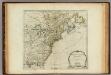
North America from the French of Mr. D'Anville.
1 : 6350000 Jefferys, Thomas
Die Vereinigten Staaten von Nord-Amerika
Allgemeiner Atlas [Walch, Johannes] im Verlag bei Johannes Walch
U.S., Canada.
1 : 15600000 Huntington, Nathaniel G. (Nathaniel Gilbert), 1785-1848
The United States of America at the time of the ratification of the Constitution, from original maps in the American Geographical Society of New York
1 : 6860480 Map of the United States, with 4 maps of "Claims and cessions of western lands, 1776-1802." In upper margin: "The United States of America at the time of ratification of the Constitution, from original maps in the American Geographical Society of New York and the Library of Congress at Washington. Issued by the United States Sesquicentennial Commission". Include decorative title cartouche and historical notes. Relief shown by hachures. Prime meridian is Philadelphia. Series: "This map is one of a series of similar colored maps, depicting the 13 original states, from New Hampshire to Georgia at the time of the formati John, Mitchel, 1711-1768 Washington, D.C. : United States Constitution Sesquicentennial Commission, [Washington, D.C.] : U.S. Geological Survey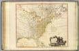
United States of North America.
1 : 6350000 Faden, William, 1750?-1836
Amerique Septentrionale.
1 : 2000000 Mitchell, John
United States
A new general atlas of modern geography, consisting of a complete collection of maps of the four quarters of the globe Wyld, James James Wyld
A map of the United States and Canada, New-Scotland, New-Brunswick and New-Foundland = Carte des Etats-Unis, avec le Canada, la Nouvelle Ecosse, le Nouveau Brunswick & Terre-Neuve
1 : 6500000 dressée par Lapie gravé par P. A. F. Tardieu ; écrit par J. J. Pachoux Paris [etc.] : P.A.F. Tardieu [etc.]
A new map of North America from the latest discoveries / J. Spilsbury, sculp.
from Parts J. Spilsbury,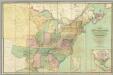
Map of the United States.
1 : 2000000 Walker, John & Alexander
United States or Fredon / H.G. Spafford, del. ; G. Fairman sc.
from General geography, and rudiments of useful knowledge. In nine sections ... Illustrated with an elegant improved plate of the solar system ... a map of the world ... of the United States ... and several engravings on wood. Digested on a new plan, and designed for the use of schools. By H. G. Spafford.
A new and correct map of North America: in which the places of the principal engagements during the present war are accurately inserted / Jno. Lodge sculpt.
from Parts John Lodge,
A Map of the British and French settlements in North America.
from Parts J. (John) Hinton, Newgate Street: [London],
Carte generale des treize Etats Unis, de l'Amerique septentrionale
Map of the United States.
1 : 3660000 Carey, Mathew
Map of the United States.
1 : 3675000 Carey, Mathew
Vereinigte Staaten von Nord Amerika, ohne das West Gebiet der Union

Ètats-Unis de l'Amérique septentrionale avec les Isles Royale, de Terre Neuve, de St. Jean, l'Acadie &c.
from Charts and maps Chez Delamarche, géogr.: Paris; Delamarche, Charles François,
Ètats-Unis de l'Amérique septentrionale avec les Isles Royale, de Terre Neuve, de St. Jean, l'Acadie &c.
from John H. Levine Collection Chez Delamarche, géogr.: Paris; Delamarche, Charles François,
U.S. Eastern.
1 : 8870400 Letts, Son & Co.
Possessions Francoises.
1 : 12500000 Clouet, J. B. L. (Jean-Baptiste Louis), b. 1730
Mitchell's map of the United States : showing the principal travelling turnpike and common roads, on which are given the distances in miles from one place to another, also the courses of the canals & rail roads throughout the country, carefully compi
from Whole