Maps of Tidore
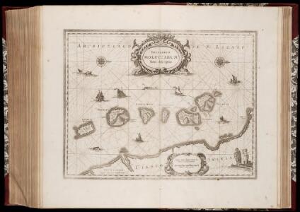
Insularum Moluccarum nova descriptio
1 : 270000 Annotatie: Zeekaart; Kaart uitg. in de periode ca. 1633-ca. 1680; Origineel is Blad 193 in atlas factice; Annotatie geografische gegevens: Schaalstokken op kaart: 2 Milliaria Germanica communia (=5,4 cm), en: 3 Milliaria Gallica communia (=6 cm); Westen boven Johannes Janssonius 1588-1664 Amstelodami : Apud Ioannem Ianssonium
Insularum Moluccarum Nova descriptio [Karte], in: Novus atlas absolutissimus, Bd. 6, S. 153.
1 Karte aus Atlas Janssonius Offizin
Insularum Moluccarum Nova descriptio [Karte], in: Gerardi Mercatoris et I. Hondii Newer Atlas, oder, Grosses Weltbuch, Bd. 2, S. 359.
1 Karte aus Atlas Mercator, Gerhard und Hondius, Jodocus Jansson, Jan
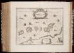
Moluccae Insulae Celeberrimae [Karte] Bachian I. [Nebenkarte], in: Theatrum orbis terrarum, sive, Atlas novus, Bd. 2, S. 256.
1 Karte aus Atlas Blaeu, Joan Blaeu, Willem Janszoon
MOLVCCÆ | INSULÆ | CELEBERRIMÆ
AMSTELODAMI, | Iudocus Hondius | excudit
Moluccae Insulae Celeberrimae [Karte] Bachian I. [Nebenkarte], in: Novus Atlas, das ist, Weltbeschreibung, Bd. 2, S. 271.
1 Karte aus Atlas Blaeu, Joan Blaeu, Willem Janszoon
Moluccae Insulae Celeberrimae [Karte] Bachian I. [Nebenkarte], in: Le théâtre du monde, ou, Nouvel atlas contenant les chartes et descriptions de tous les païs de la terre, Bd. 2, S. 244.
1 Karte aus Atlas Blaeu, Willem Janszoon und Blaeu, Joan Blaeu, Willem Janszoon

[P[oelau] Makian] / opgenomen door den Topografischen Dienst in 1924
Topografische Dienst Batavia Batavia : Reproductiebedrijf Topografische Dienst
[Tidore] / opgenomen door den Topografischen Dienst in 1922
Topografische Dienst Batavia Batavia : Reproductiebedrijf Topografische Dienst
Ternate / prepared under the direction of the Chief of Engineers U.S. Army by the Army Map Service
Army Map Service U.S. Army Washington D.C. Washington D.C. : Army Map Service
[Dodinga-Baai] / samengesteld door den Topografischen Dienst in 1922-1923
Topografische Dienst Batavia Batavia : Reproductiebedrijf Topografische Dienst
[Akelamo] / opgenomen door den Topografischen Dienst in 1922-1923
Topografische Dienst Batavia Batavia : Reproductiebedrijf Topografische Dienst
[B[oe]k[oe] Doefoek] / opgenomen door den Topografischen Dienst in 1922-1923
Topografische Dienst Batavia Batavia : Reproductiebedrijf Topografische Dienst
Schetskaart van de eilanden Ternate en Hiri / [door de] Top[ographische] Inr[ichting] Batavia ; Opgenomen met de boussole-tranchemontagne, zakkompas, hoogtebarometer en op den pas door den Inl[andsche] verkenner Makatipu
Topografische Inrichting Batavia Batavia : Top[ographische] Inr[ichting]
Schetskaart van de eilanden Tidore en Maitara / Topogr[aphische] Inrichting
Topographische Inrichting Batavia Batavia : Topogr[aphische] Inrichting
Verzamelde plannen volgens de laatste opnemingen en berigten
door F.A.A. Gregory [...] behoorende bij deszelfs kaart der Moluksche eilanden en vaarwaters [...] 1845 uitg. vanwege de Commissie tot verbetering der Oost-Indische zeekaarten door Jacob Swart [...] Amsterdam : Wed. Gerard Hulst van Keulen
[Djailolo] / opgenomen door den Topografischen Dienst in 1925
Topografische Dienst Batavia Batavia : Reproductiebedrijf Topografische Dienst
[G[oenoeng] Tabobo] / opgenomen door den Topografischen Dienst in 1925
Topografische Dienst Batavia Batavia : Reproductiebedrijf Topografische Dienst
Schetskaart van het Eiland Halmahera en omliggende eilanden / Topographische Inrichting
Topographische Inrichting Batavia Batavia : Topographische Inrichting
Voorloopige schetskaart van de eilanden Halmahera en Morotai / [Topographische Inrichting]
[Batavia : Javasche Boekhandel & Drukkerij]
Schetskaart van het Eiland Halmahera en omliggende eilanden / Topographische Inrichting
Topographische Inrichting Batavia Batavia : Topographische Inrichting
Bladwijzer van de Afdeeling Ternate
Topografische Inrichting Batavia Bat[avia] : Top[ografische] Inr[ichting]
Halmahera / Topografische Dienst
Topografische Dienst Batavia Batavia : Reproductiebedrijf Topografische Dienst
Kaart van een gedeelte der Molukken : tot toelichting van Dr. H.A. Bernstein's laatste reis, 18 October 1864 tot 19 April 1865, van Ternate naar Nieuw-Guinea en Salawati met de laatste Molukken-kaart (1878) als grondslag, uit de jongste onderzoekingen en uit eigen opnamen saamgesteld / door S.C.J.W. van Musschenbroek ; W.J. van der Velde lith.
[S.l. : s.n.]
Kaart van het Eiland Djilolo of Halemahera : afkomstig uit de Atlas der Admiraliteit van Amsterdam vervaardigd door Isaac de Graaff in het laatst der 17e of begin der 18e eeuw
[S.l. : s.n.]
Kaart van het Noorder Schier Eiland van Halemahera / door C.F.H. Campen ; de teekenaar Ch. Martin
Koninklijk Nederlandsch Aardrijkskundig Genootschap Amsterdam [Amsterdam : Stemler]
Kaart van het Ternataansche Distrikt Kau op Halemahera / vervaardigd door C.F.H. Campen, officier der Nederlandsch Indische Infanterie
Nederlandsch Aardrijkskundig Genootschap Amsterdam Amsterdam : Brinkman
Bladwijzer van Halmahera schaal 1:100.000 : Ternate en Hiri, Tidore en Maitata en Lolobata, Binau Rivier en Miti Eiland schaal 1:20.000
[S.l. : s.n.]